This item has been sold, but you can get on the Waitlist to be notified if another example becomes available, or purchase a digital scan.
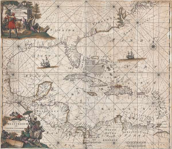
1680 De Wit Map of the West Indies and the North American Coast
IndiarumOccidentalium-dewit-1680$1,450.00

Title
Indiarum Occidentalium Tractus Littorales cum Insulis Caribicis. / Pascaert van Westindien ende Caribise Eylanden.
1680 (undated) 19.5 x 23 in (49.53 x 58.42 cm) 1 : 8500000
1680 (undated) 19.5 x 23 in (49.53 x 58.42 cm) 1 : 8500000
Description
A fine and rare old color example of the second edition of Frederick de Wit's 1680 nautical chart or maritime map of the West Indies, Central America, Gulf of Mexico, and Florida. Printed during the Golden Age of Caribbean Piracy, this sea chart covers the eastern coast of North America from Cape May and the Chesapeake Bay to Central America and the Spanish Main. It offers a reasonably detailed depiction of the West India Islands, Florida, and Central America. The American seaboard north of Florida is exaggerated in its northeasterly inclination, an error that would be corrected in the early 18th century. Similarly, the Yuchatan appears in a narrow configuration common in most Dutch maps until the late 18th century.. Note the Mississippi River Delta has not yet been identified, but numerous place names along the coast are identified, if only conjecturally. The whole is filled with rhumb lines and illustrations of galleons. Cartographically the map was partially derived from Hessel's Gerritsz's map of 1631 with updates derived from Joannes van Loon's map of 1661.
This map was published in de Wit's Orbis Maritimus ofte Zee Atlas of 1680. It was engraved by Romeyn de Hooghe. The second edition can be identified by the presence of the western cost of Central America and the addition of New Amsterdam in the upper right quadrant. Two subsequent editions were issued by L. Renard and the Ottens family.
All editions of this map are scarce.
CartographerS
Frederik de Wit (1629 - 1706) was a Dutch Golden Age cartographer active in the second half of the 17th and the early 18th centuries. De Wit was born of middle class Protestant stock in the western Netherlandish town of Gouda. He relocated to Amsterdam sometime before 1648, where he worked under Willem Blaeu. His first attributed engraved map, a plan of Haarlem for Antonius Sanderus' Flandria Illustrata, was issued around this time. He struck out on his own in 1654. The first chart that De Wit personally both drew and engraved was most likely his 1659 map of Denmark, REGNI DANIÆ Accuratissima delineatio Perfeckte Kaerte van ‘t CONJNCKRYCK DENEMARCKEN. His great wall map of the world and most famous work, Nova Totius Terrarum Orbis Tabula appeared one year later. Following the publication of his wall map De Wit quickly rose in prominence as a both cartographer and engraver. He married Maria van der Way in 1661 and through her became a citizen of Amsterdam in 1662. Around this time he also published his first major atlas, a composite production ranging in size from 17 to over 150 maps and charts. Other atlases and individual maps followed. In 1689 De Wit was granted a 15 year Privilege by the Dutch States General. (An early copyright that protected the recipient's rights to print and publish.) He was recognized with the honorific 'Good Citizen' in 1694. De Wit died in 1706 after which his wife Maria continued publishing his maps until about 1710. De Wit's son, Franciscus, had no interest in the map trade, instead choosing to prosper as a stockfish merchant. On her own retirement, Maria sold most De Wit maps and plates at a public auction. Most were acquired by Pieter Mortier and laid the groundwork for the 1721 rise of Covens and Mortier, the largest Dutch cartographic publishing house of the 18th century. More by this mapmaker...
Romeyn de Hooghe (Septemer 10, 1645 – June 10, 1708) was a Dutch engraver, portrait artist, caricaturist, painter, and sculptor active in Amsterdam during the second half of the 17th century and opening years of the 18th century. De Hooghe was born in Amsterdam and revealed an early talent for all forms of visual arts. He became known caricaturist and is admired today as one of the first great graphic satirists. During his life he was criticized for his proclivity towards humorous tongue-in-cheek subjects. He nonetheless developed a following and produced a prolific amount of work, some 5000 engravings. He was a member of the Confrerie Pictura in 1662 and 1683. Cartographically he is best known for his decorative border work. His disciples were Filibert Bouttats (1654-after 1731), Filibertus Bouttats (1635–1707), Frans Decker, François Harrewijn, Jacobus Harrewijn, Aernout Naghtegael, Laurens Scherm, and Adriaen Schoonebeek. De Hooghe died in Haarlem on June 10, 1708. Much of his work continued to be republished posthumously. Learn More...
Source
de Witt, F., Orbis Maritimus ofte Zee Atlas, (Amsterdam: de Wit) 1675 (first edition).
Condition
Good condition. Light transference and toning. Old Color. Slight repaired oxidization loss in the Bahamas. Some centerfold wear. Backed on archival tissue. Trimmed to neatline.
References
OCLC 47681817. Burden, P, The Mapping of North America II, #468, State 2.