This item has been sold, but you can get on the Waitlist to be notified if another example becomes available, or purchase a digital scan.
1837 Berghaus 'Atlas von Asia' Map of Sumatra and Singapore
InselSumatra-berghaus-1837$4,500.00

Title
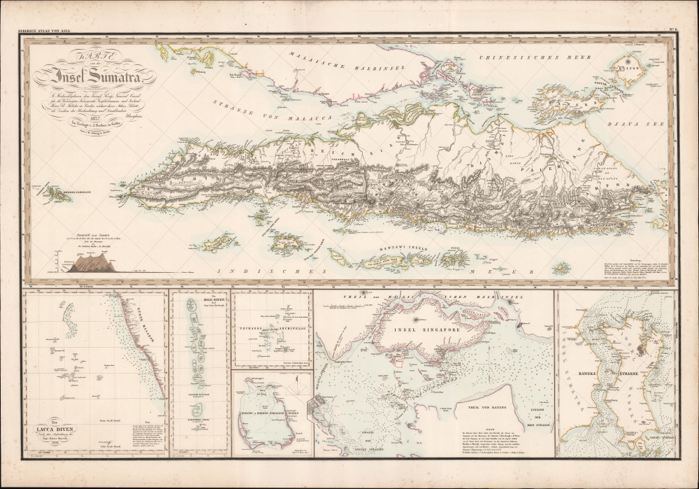
Karte von der Insel Sumatra.
1837 (dated) 27 x 38 in (68.58 x 96.52 cm)
1837 (dated) 27 x 38 in (68.58 x 96.52 cm)
Description
This is a striking 1837 Heinrich Berghaus map of Sumatra with important insets of Singapore and the Maldives. It was issued for Berghaus' looseleaf Atlas von Asien, the best informed general cartographic work on Asia to appear in the mid-19th century.
Along the bottom of the map there are six insets, the most important of which is the large detail map of Singapore. We recognize influence from James Horsburgh’s nautical charts. Singapore although only founded 18 years earlier, was already, by 1837, a thriving trade center. Similarly, Berghaus relies on Horsburgh for a tenuous mapping of the Maldives, at the time a series of inhabited atolls all but inaccessible due because the atolls were surrounded by a maze of dangerous coral reefs.
Other insets include the Lakshadweep Islands (Lacca Diven) off the coast of Malabar, India, after Robert Moresby; I. C. Ross’s map of Cocos (Keeling) Islands, located far southwest of Sumatra and today administered by Australia; and the Banka Strait near Sumatra, often visited for its tin reserves and as an alternate route to Singapore.
A Closer Look
Multiple maps in a single sheet. The primary map details Sumatra when it was the center of global pepper cultivation. This map is oriented to the east and contains Singapore and the southern parts of Malaya. The map exhibits greater detail along the western coasts, which were frequently visited by pepper traders from throughout Europe and America.Along the bottom of the map there are six insets, the most important of which is the large detail map of Singapore. We recognize influence from James Horsburgh’s nautical charts. Singapore although only founded 18 years earlier, was already, by 1837, a thriving trade center. Similarly, Berghaus relies on Horsburgh for a tenuous mapping of the Maldives, at the time a series of inhabited atolls all but inaccessible due because the atolls were surrounded by a maze of dangerous coral reefs.
Other insets include the Lakshadweep Islands (Lacca Diven) off the coast of Malabar, India, after Robert Moresby; I. C. Ross’s map of Cocos (Keeling) Islands, located far southwest of Sumatra and today administered by Australia; and the Banka Strait near Sumatra, often visited for its tin reserves and as an alternate route to Singapore.
Publication History and Census
This map was published in 1837 by Heinrich Berghaus and Justus Perthes. It was engraved in Berlin by Wilhelm Jätting. The map is no. 11 of Berghaus's Atlas von Asien, all the individual maps of which are exceedingly desirable. We know of examples in the David Rumsey Collection, the Bibliothèque nationale de France, and a host of German collections, but little or no presence on the private market.CartographerS
Heinrich Karl Wilhelm Berghaus (May 3, 1797 – February 17, 1884) was a German (Prussian) geographer who founded the Geographische Kunstschule in Potsdam and trained several important German geographers and cartographers of the late 19th century, including August Heinrich Petermann and his nephew Hermann Berghaus. The elder Berghaus also was a friend and associate of Alexander von Humboldt, producing some of the maps in his publications. In 1837, he inherited the Daniel Gottlob Reymann (1759 – 1837) monumental Geographischer Specialatlas von Deutschland. Berghaus is best known for his own influential and wide-ranging atlases, namely Atlas von Asien, published between 1833 and 1837, and Berghaus' Physikalischer Atlas, published in multiple editions in the 1830s - 1840s. Although Atlas von Asien was a commercial failure, it was regarded as a work of supreme quality, boosting the reputation of the publisher Justus Perthes and setting up their next collaboration, Berghaus' Physikalischer Atlas, for success. More by this mapmaker...
Johan Georg Justus Perthes (September 11, 1749 - May 2, 1816) was one of the most important German cartographic engravers of the 19th century. He was born in the Thuringian town of Rudolstadt, the son of a court physician. In 1778, he began working as a bookseller in Gotha. Perthes began his publishing empire shortly thereafter with the 1784 issue of the famed survey of European nobility known as the Almanac de Gotha. In the next year, 1785, he founded the cartographic firm of Justus Perthes Geographische Anstalt Gotha. His son Wilhelm Perthes (1793 - 1853) joined the firm in 1814. Wilhelm had prior publishing experience at the firm of Justus Perthes' nephew, Friedrich Christoph Perthes, who ran a publishing house in Hamburg. After Justus Perthes died in 1816, Wilhelm took charge and laid the groundwork for the firm to become a cartographic publishing titan. From 1817 to 1890. the Perthes firm issued thousands of maps and more than 20 different atlases. Along with the visionary editors Hermann Berghaus (1797 - 1884), Adolph Stieler (1775 - 1836), and Karl Spruner (1803 - 1892), the Perthes firm pioneered the Hand Atlas. When Wilhelm retired, management of the firm passed to his son, Bernhardt Wilhelm Perthes (1821 – 1857). Bernhardt brought on the cartographic geniuses August Heinrich Peterman (1822 - 1878) and Bruno Hassenstein (1839 - 1902). The firm was subsequently passed to a fourth generation in the form of Berhanrd Perthes (1858 – 1919), Bernhard Wilhelm's son. The firm continued in the family until 1953 when, being in East Germany, it was nationalized and run as a state-owned enterprise as VEB Hermann Haack Geographisch-Kartographische Anstalt Gotha. The Justus family, led by Joachim Justus Perthes and his son Wolf-Jürgen Perthes, relocated to Darmstadt where they founded the Justus Perthes Geographische Verlagsanstalt Darmstadt. Learn More...
Wilhelm Jättnig (fl. c. 1830 - 1840) was a German engraver based in Berlin. He is one of the lesser-known scions of Carl Friedrich August Jättnig (1794 – 1849), the youngest son of the engraving dynasty’s founder, Carl Jättnig (1766 – 1819). Wilhelm worked with his father to engrave maps for Daniel Gottlob Reymann’s (1759 – 1837) monumental Geographischer Specialatlas von Deutschland. When Reymann died, the project was passed to Heinrich Karl Wilhelm Berghaus (1797 – 1884). Wilhelm continued to work with Berghaus on the atlas of Germany as well as on Berghaus’ important Atlas von Asien. His uncle, Carl Christian Ferdinand Jättnig (1789 - 1847), and many nephews of the Jättnig name, were also a prominent engravers. Learn More...
Source
Berghaus, H., Atlas von Asien, (Gotha: Justus Perthes) 1832 - 1837.
Heinrich Berghaus's Atlas von Asien was an 18-map loose-leaf atlas issued by Justus Perthes between 1832 and 1858. Of the 18 proposed maps, only 15 were published. Individual maps were large with unprecedented detail. These include 10 land maps and 7 nautical charts derived from British, Dutch, and Portuguese colonial, scientific, and diplomatic missions. Despite this, the project was a financial failure due to the high cost of engraving such large and intricate maps. It took more than 25 years for the maps to be fully published and, according to the Perthes archive, only 20 sets were ultimately bound and sold. The publication run per map ran between 200 to 550 maps, most of which were offered separately. The breadth, detail, and comprehensiveness of the work surpassed any previous mapping of the respective subjects. Although not a direct financial success, the Atlas von Asien was a monumental cartographic accomplishment that put the Perthes firm on par with the great cartographic firms of England and France. The Atlas von Asien was largely forgotten until recent times, when it has become desirable among collectors and institutions.
Condition
Very good. Slight margin foxing.