This item has been sold, but you can get on the Waitlist to be notified if another example becomes available, or purchase a digital scan.
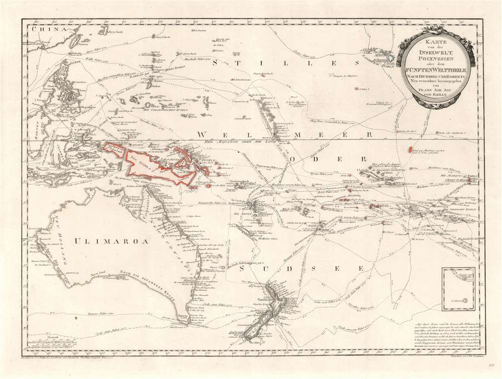
1796 Djurberg Map of Polynesia with indigenous name for Australia (Ulimaroa)
InselweltPolynesien-reilly-1796$550.00

Title
Karte von der Inselwelt, Polynesien oder dem Fünften Welttheile Nach Djurberg unde Roberts.
1796 (undated) 19.5 x 28.5 in (49.53 x 72.39 cm) 1 : 20000000
1796 (undated) 19.5 x 28.5 in (49.53 x 72.39 cm) 1 : 20000000
Description
This important 1796 map of Australia and Polynesia is one of the very few maps to use the indigenous terms for Australia and New Zealand: Ulimaora (Australia), Tavai-Poenammoo (New Zealand South Island) and Ealiei-Nomauwe (North Island). All three of these terms are extracted from accounts of Cook's voyages.
Ulimaora and other Indigenous Toponomy
The usage of Ulimaroa to identify Australia can be traced to the Swedish geographer Daniel Djurberg, who introduced it in his Cosmografie Samt Beskrifning om Jorden i Allmänhet (Cosmography and General Description of the Earth). Djurberg writes,On page 436 of Hawkesworth’s account of Cook’s first voyage, Ulimaroa is mentioned as the biggest island in the world. I should give a reason for this name. This land is called New Holland in a lot of maps, but for what reason I do not know; there is no similarity between Holland in Europe and this land, neither in size nor in the area’s character. You find in the account of the famous English sailor Cook’s journeys that when he was on the northern coast of New Zealand, he asked the inhabitants there if they knew any other country, to which they replied that to the north-west of their home, a quite large land was located, which they called Ulimaroa. I have decided to maintain this name as given to this land by its neighbors; besides it is better than New Holland.On a secondary level, the map is notable for its detailed accounting of the various exploratory missions to the South Pacific in the 17th and 18th centuries. These include the routes of James Cook , Abel Tasman, Philip Carteret, Alvaro de Mendaña de Neira, Pedro Fernandes de Queirós, Charles Clerke, and Samuel Wallis. Its coverage extends from Taiwan (Formosa) and Hawaii, south as far as New Zealand.
Publication History and Census
This map was first issued in 1780, in Swedish, by Daniel Djurberg. The present example is the 1796 issue by Austrian publisher Franz Johann Joseph von Reilly. It is notable for being more finely engraved than the earlier editions.CartographerS
Daniel Djurberg (June 3, 1744 – October 2, 1834) was a Swedish geographer and cartographer active in the late 18th and early 19th centuries. Djurberg as the grandson of the well-known theologian of the same name. He was born in Gävle, Sweden, and studied at Uppsala University. He held academic positions at several schools, including at the Katarina Skola (1776) and Klara Skola (1782). As a cartographer one of Djurberg's idiosyncrasies was using alternative indigenous nomenclature: Vingandacoa for North America and Ulimaroa for Australia, among others. More by this mapmaker...
Franz Johann Joseph von Reilly (August 18, 1766 – July 6, 1820) was an Austrian author, humorist, cartographer, and map publisher active in the late 18th century and early 20th century. Joseph was born in Vienna, Austria, the the son of court master John Reilly. He initially worked in the Austrian Civil Service, but was apparently unpaid and unsuccessful in that operation, quitting the position after 3 years. With significant wealth inherited from his father, Reilly dedicated himself to printing and cartography, publishing several major atlases between 1789 and 1806. He is most famous for publishing the Grosser Deutscher Atlas (1794 - 1796), the first world atlas fully published and produced by an Austrian. This atlas was probably in spired by Franz Anton Schrämbl's (1751 - 1803) Allgemeiner Grosser Atlass. During his career he produced thousands of maps and multiple atlases, but retired form cartography in 1806. Learn More...
Source
Rielly, F. J. J., Grosser Deutscher Atlas (Vienna) 1794 - 1796.
The Grosser Deutscher Atlas, published by Franz Johann Joseph von Reilly (1766 - 1820) between 1794 and 1796 is notable as the first world atlas crated, produced, and published by an Austrian. The atlas is an impressive elephant folio resembling Franz Anton Schraembl's Allgemeiner Grosser Atlas, which may have provided inspiration.
Condition
Very good.
References
OCLC 222110400.