This item has been sold, but you can get on the Waitlist to be notified if another example becomes available, or purchase a digital scan.
1943 Owens Map of the Possible Allied Invasion of the Balkans
InvasionBalkans-owens-1943$100.00

Title
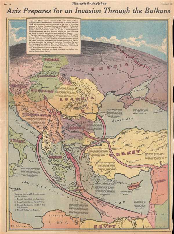
Axis Prepares for an Invasion Through the Balkans.
1943 (dated) 21.75 x 15.5 in (55.245 x 39.37 cm)
1943 (dated) 21.75 x 15.5 in (55.245 x 39.37 cm)
Description
This is a Friday, July 9, 1943 Charles Hamilton Owens and Minneapolis Morning Tribune map of the Balkans and Eastern Europe. The map depicts the region from Italy, Malta, and Libya to Russia, Turkey, and the Middle East and from Russia, Poland, and Germany to Egypt and Libya. Fighting in North Africa ended with the surrender of German and Italian forces on May 13, 1943, making the Eastern Front the only active combat against Axis forces in the European and Mediterranean theaters. As of July 9th, it was believed, due to a brilliant misinformation campaign by the Allies, that the Balkans would play host to the next major Allied invasion. As stated in the text box in the upper-left corner of this map, the Allies mounted a successful invasion of the Balkans during World War I, which meant that the Axis had to take the threat seriously. Four different possible invasion routes are illustrated here: one through the Adriatic Sea and Yugoslavia; another through the Aegean and Salonika, Greece; a third through the Dardanelles, the Black Sea, and Romania (Rumania); and a fourth overland through Turkey and Bulgaria. Pros and cons of each of these routes are discussed on the map, allowing readers to understand that each of these routes presents its own difficulties. Thus, the newspaper's readers would have a better understanding of what Allied troops were facing, when the actual invasion was launched, and the official plan was revealed to the world.
In fact, the following day, July 10, 1943, the Allies invaded Sicily, unveiling the elaborate hoax that was the Allied invasion of the Balkans. Even though the invasion did not actually happen, the deception campaign served a valuable purpose. By forcing the Axis powers to plan for a possible invasion in the Balkans, the Germans pulled one fifth of their troops out of combat on the Eastern Front against the Russians to reinforce Italian troops in the Balkans. They also began building fortifications in the region, using resources that could have been consumed somewhere else, possibly with greater effect on actual combat. By diverting Axis resources to the Balkans, the Allies forced the consumption of resources in a theater where they would be of almost no use to the enemy.
When Charles Hamilton Owens drew this map, he was doubtless inspired by the work of Richard Edes Harrison, an American illustrator and cartographer who, working for Fortune magazine, pioneered a new style of representing the world for WWII era propaganda maps. Edes developed the convention of using spherical perspective with an exaggerated vertical dimension, as on the present map, to illustrate part of the world as part of a greater global situation. This map was drawn by Charles Hamilton Owens and published in the Minneapolis Morning Tribune on Friday, July 9, 1943.
CartographerS
Charles Hamilton Owens (Feb 16, 1881 - March 3, 1958) was an American painter and illustrator and staff illustrator for the Los Angeles Times. Born in San Francisco, he had a passion for drawing from a young age. After landing a job as a messenger for The San Francisco Examiner, Owens began being taught his trade by the newspaper's illustrators. Although it is unclear exactly where Owens started his career as a newspaper staff artist, his reputation was launched by his detailed sketches of the 1906 San Francisco earthquake and fire for a New York paper, using only wire reports and his knowledge of the city. By 1910, Owens was working for the Los Angeles Examiner. Even at this point in his career, Owens was known for experimenting with new forms of illustration, fusing drawings of events with photographs. Owens's map of the Titanic disaster used a high oblique perspective, 'capturing the earth's sphericity and showing the polar regions on a curving horizon.' By the 1920s, Owens reputation as an artist in Los Angeles had grown beyond the realm of journalism. He had a studio and received commissions for landscapes and had exhibited watercolors of California and Hawaii landscapes. Thus, when Owens began creating his war series in April/May 1942, he had all the necessary skills to create visually striking works. The Los Angeles Times began a series of maps for its readers, which were full-page inserts that would appear every Monday and Saturday. Owens's maps would be included in the Monday issues, and a Rand McNally map would be included on Saturdays. The Rand McNally maps, however, were discontinued on June 27, 1942, but Owens's maps continued to be printed. His last war map was published on September 10, 1945, a little over a week after the Japanese surrender. Owens died in Los Angeles on March 3, 1958. More by this mapmaker...
The Minneapolis Tribune (1867 - present) was founded by Colonel William S. King, William D. Washburn, and Dorilus Morrison and the first issue was published on May 25, 1867. In 1941, the Cowles family of Des Moines, Iowa bought the Tribune and merged it with their other holdings in Minneapolis, giving the Cowles family ownership of all the city's major newspapers. The Tribune became the city's morning newspaper, and the Star-Journal was the evening newspaper. The two published a joint Sunday edition. The newspaper is still published today, under the name Star Tribune. Learn More...
Condition
Very good. Newsprint. Closed minor margin tears professionally repaired on verso. Text on verso.