This item has been sold, but you can get on the Waitlist to be notified if another example becomes available, or purchase a digital scan.
1676 John Speed Map of Ireland
Ireland-speed-1676$1,250.00

Title
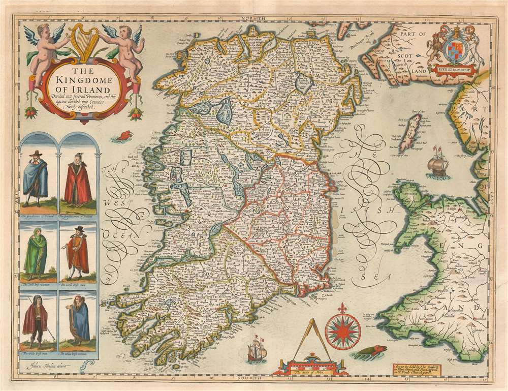
The Kingdome of Irland Devided into Severall Provinces, and thē againe devided into Counties. Newly described.
1676 (undated) 15 x 20 in (38.1 x 50.8 cm) 1 : 1650000
1676 (undated) 15 x 20 in (38.1 x 50.8 cm) 1 : 1650000
Description
This is John Speed's map of Ireland, the first map of Ireland published in an English atlas. Engraved in 1610, It was included in Speed's The Theatre of the Empire of Great Britaine, which was the first collection of maps of the counties of the British Isles. The engraving is the work of Jodocus Hondius, who engraved many of the plates of Speed's atlases. This was fortunate for Speed. Hondius had become familiar with the Irish surveys of Robert Lythe. Lythe, an English surveyor and topographer, had been tasked by the British government between 1567 and 1570 to survey Ireland in the wake of the Tudor Conquest, in order to aid the garrisoning and colonization of the island. Lythe's survey proved a mammoth undertaking. Of it, J. H. Andrews remarked:
Since the number of Lythe’s Irish place-names runs to several thousands (no other Elizabethan surveyor reached four figures) his visit must—on grounds of quantity alone—be accounted the most important event in the cartographic history of sixteenth-century Ireland.Despite these being the most up-to-date surveys of Ireland, they were not well disseminated until the end of the 17th century. Ortelius' maps, for example, were based on Mercator's outdated mapping of the 1560s, and did not benefit from Lythe's contemporaneous surveys. Hondius, on the other hand, had encountered Lythe's work while living in England, and he drew on it while executing Pieter van den Keere's 1592 Hyberniae novissima descriptio as well as the map he engraved for Speed. (The sole known copy of the Kaerius map survives in Linen Hall, Belfast.)
The Depictions of the Irish
At left are illustrations of men and women of various stations of Irish society: 'Gentlemen' and 'Gentlewomen,' the 'Civil' Irish man and woman, and lastly a pair of 'The Wilde Irish,' emphasizing to an English audience both the familiar mode of dress of the urban and noble Irish, while at the same time highlighting the more alien qualities of the population away from the larger towns. The English verso text reveals more:'The Irish… are a strong and bold people, martiall and prodigiall in war, nimble, stout and haughtie in heart; careless of life, but greedy of glory; courteous to strangers, constant in love, light of belief, impatient of injury, given to fleshly lusts, and in enmity implacable.'Among the other subjects addressed, Speed the historian also describes Ireland's land, climate, and cold remedies:
'The ayre of this land is delectable and wholesome, though neither so cleare nor subtile as is ours of England... The soyle... is uneven, woody, wilde, waterish and boggie, so full of Loghs and Meeres, that great ponds of water are found upon the high mountains. These indeed make the places somewhat dangerous to new comers, by breeding of rheums, dysenteries, and fluxes, whose usual remedie is Uskebah, a wholesome Aqua vitae, that drieth more, and enflameth less, then many other hot confections.'The map's decorative engraving includes an ornate cartouche, surmounted by an Irish harp and flanked with putti;The British Royal arms appear in the upper right-hand corner of the map. The waters around Ireland are prowled by two sea monsters and a pair of sailing ships. There is an elegant compass rose.
Publication History and Census
This map was engraved by Jodocus Hondius in 1610 for inclusion in John Speed's Regnvm Hiberniae Continens. published in London by Sudbury and Humble in 1616 It continued in publication in Speed's atlases in all their editions. This example bears the imprint of Basset and Chiswell, whose edition of Speed's atlas was published in 1676. Seven examples of the separate map, in various editions, appear in institutional collections in OCLC.CartographerS
John Speed (1542 - 1629) was an important English historian and cartographer active in the early 17th century. Speed was born in Fardon, Cheshire and apprenticed under his father as a tailor. Though his heart was never in tailoring, Speed dedicated himself to this profession until he was about 50 years old. During all the time, Speed dedicated his spare time to research as amateur historian and mapmaker - even preparing several maps for Queen Elizabeth. In London, Speed's interest in history lead him to join the Society of Antiquaries. Eventually he befriended the wealthy Sir Fulke Greville, who sponsored his researches and eventually freed him from the haberdashery profession. Working with William Camden, Speed eventually published his 1611 Historie of Great Britaine. Though this history itself was amateurish and of minimal importance, Speed's inclusion of numerous maps of British Cities and town was seminal. In many cases these plans were the first maps ever issued of their respective subjects. Later, turning his attention more fully to Geography, Speed published the magnificent atlas Theatre of the Empire of Great Britaine and, just prior to his death, the 1627 A Prospect of the Most Famous Parts of the World. These were the first British world atlases and have a landmark position in the history of cartography. These atlases continued to be published well after Speed's death. More by this mapmaker...
Jodocus Hondius (October, 14 1563 - February 12, 1612) was an important Dutch cartographer active in the late 16th and early 17th centuries. His common name, Jodocus Hondius is actually a Latinized version of his Dutch name, Joost de Hondt. He is also sometimes referred to as Jodocus Hondius the Elder to distinguish him from his sons. Hondius was a Flemish artist, engraver, and cartographer. He is best known for his early maps of the New World and Europe, for re-establishing the reputation of the work of Gerard Mercator, and for his portraits of Francis Drake. Hondius was born and raised in Ghent. In his early years he established himself as an engraver, instrument maker and globe maker. In 1584 he moved to London to escape religious difficulties in Flanders. During his stay in England, Hondius was instrumental in publicizing the work of Francis Drake, who had made a circumnavigation of the world in the late 1570s. In particular, in 1589 Hondius produced a now famous map of the cove of New Albion, where Drake briefly established a settlement on the west coast of North America. Hondius' map was based on journal and eyewitness accounts of the trip and has long fueled speculation about the precise location of Drake's landing, which has not yet been firmly established by historians. Hondius is also thought to be the artist of several well-known portraits of Drake that are now in the National Portrait Gallery in London. In 1593, Hondius returned to Amsterdam, where he remained until the end of his life. In 1604, he purchased the plates of Gerard Mercator's Atlas from Mercator's grandson. Mercator's work had languished in comparison to the rival atlas, Theatrum Orbis Terrarum by Ortelius. Hondius republished Mercator's work with 36 additional maps, including several which he himself produced. Despite the addition of his own contributions, Hondius recognizing the prestige of Mercator's name, gave Mercator full credit as the author of the work, listing himself as the publisher. Hondius' new edition of Mercator revived the great cartographer's reputation and was a great success, selling out after a year. Hondius later published a second edition, as well as a pocket version called the Atlas Minor. The maps have since become known as the "Mercator/Hondius series". Between 1605 and 1610 Hondius was employed by John Speed to engrave the plates for Speed's The Theatre of the Empire of Great Britaine. Following Hondius' death in 1612, his publishing work in Amsterdam was continued by his widow and two sons, Jodocus II and Henricus. Later his family formed a partnership with Jan Jansson, whose name appears on the Atlasas co-publisher after 1633. Eventually, starting with the first 1606 edition in Latin, about 50 editions of the Atlas were released in the main European languages. In the Islamic world, the atlas was partially translated by the Turkish scholar Katip Çelebi. The series is sometimes called the 'Mercator/Hondius/Jansson' series because of Jansson's later contributions. Hondius' is also credited with a number of important cartographic innovations including the introduction of decorative map borders and contributions to the evolution of 17th century Dutch wall maps. The work of Hondius was essential to the establishment Amsterdam as the center of cartography in Europe in the 17th century. Learn More...
Robert Lythe (fl. 1556-1571) was an English surveyor and mapmaker. Nothing is known of his early life. Although he appears to have specialized as a military surveyor, he was sufficiently broadly educated to be able to make references to hydrography, land quality, natural curiosities and local history in his manuscript maps - which were themselves neatly and attractively executed. His earliest known work was a map of the vicinity of Calais produced during an Anglo-French border dispute. His farthest-reaching work were the Irish surveys he executed between 1567 and 1570, on behalf of the British government, in order to better understand how best to garrison and colonize Ireland following the Tudor conquest. Though these surveys were not for many years broadly disseminated, they would inform to a greater or lesser extent the maps executed by Mercator, Plancius, Boazio and Norden. Jodocus Hondius drew on Lythe for the Ireland maps he produced for van der Keere and Speed: thereafter, Speed’s 1610 map of Ireland incorporating Lythe’s surveys would provide the basis for most 17th century maps of the island. Learn More...
Source
Speed, John. An Atlas of England and Wales. By J. Speed (Basset and Chiswell, London) 1676
Condition
Good condition. Marginal mend just enteriung right border. Centerfold reinforced.
References
Rumsey 12058.157 OCLC 937850687. Andrews, J. H. Colonial Cartography in a European Setting: The Case of Tudor Ireland. Woodward, D. Ed. 'The History of Cartography, Volume 3: Cartography in the European Renaissance, Part 2.' University of Chicago Press, 2007.