This item has been sold, but you can get on the Waitlist to be notified if another example becomes available, or purchase a digital scan.
1815 Thomson Map of Ireland
Ireland-thomson-1815$162.50

Title
Ireland.
1815 (dated) 24 x 20 in (60.96 x 50.8 cm) 1 : 825000
1815 (dated) 24 x 20 in (60.96 x 50.8 cm) 1 : 825000
Description
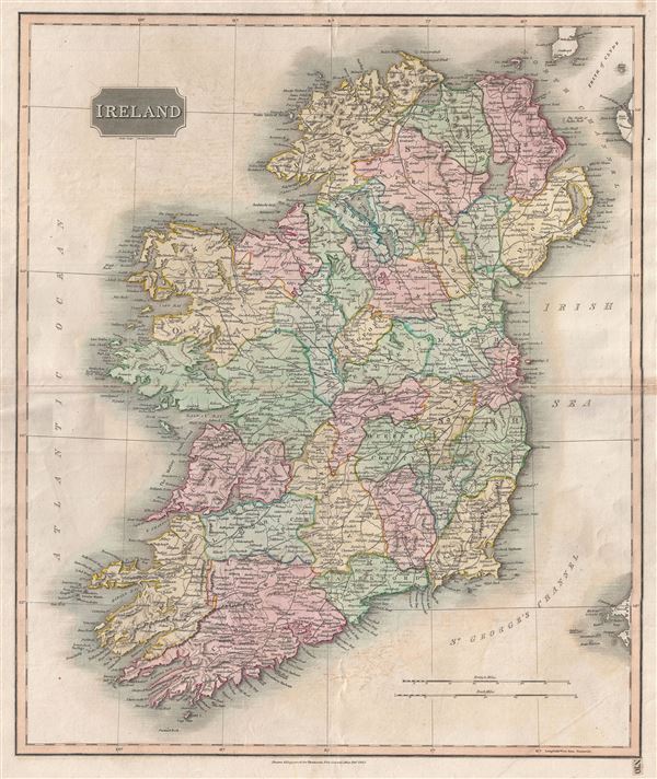
This is an attractive example of John Thomson's 1816 map of Ireland. The whole is beautifully engraved in the minimalist English style pioneered in the London and Edinburgh during early part of the 19th century. It depicts the entire Emerald Isle, divided into 32 counties, covering from Donegal in the north to Cork in the south. Towns, rivers, mountains, railroads, and various other important topographical details are noted. Elevation throughout is rendered by hachure and political and territorial boundaries are outlined in color.
In 1801, the island of Ireland became part of the United Kingdom of Great Britain and Ireland. Though Britain flourished during the 19th century, Ireland suffered a series of famines, the worst being the Great Irish Famine, which lasted from 1845 - 1849 and killed about a million people. As a result Ireland experienced a widespread exodus - mostly to the United States. By the end of the 19th century, almost 50% of immigrants into the United States hailed from Ireland.
This map is a steel plate engraving by Samuel John Neele and was prepared by John Thomson for inclusion in the 1815 edition of Thomson's New General Atlas.
CartographerS
John Thomson (1777 - c. 1841) was a Scottish cartographer, publisher, and bookbinder active in Edinburgh during the early part of the 19th century. Thomson apprenticed under Edinburgh bookbinder Robert Alison. After his apprenticeship, he briefly went into business with Abraham Thomson. Later, the two parted ways, John Thomson segueing into maps and Abraham Thomson taking over the bookbinding portion of the business. Thomson is generally one of the leading publishers in the Edinburgh school of cartography, which flourished from roughly 1800 to 1830. Thomson and his contemporaries (Pinkerton and Cary) redefined European cartography by abandoning typical 18th-century decorative elements such as elaborate title cartouches and fantastic beasts in favor of detail and accuracy. Thomson's principle works include Thomson's New General Atlas, published from 1814 to 1821, the New Classical and Historical Atlas of 1829, and his 1830 Atlas of Scotland. The Atlas of Scotland, a work of groundbreaking detail and dedication, would eventually bankrupt the Thomson firm in 1830, at which time their plates were sequestered by the court. The firm partially recovered in the subsequent year, allowing Thomson to reclaim his printing plates in 1831, but filed again for bankruptcy in 1835, at which time most of his printing plates were sold to A. K. Johnston and Company. There is some suggestion that he continued to work as a bookbinder until 1841. Today, Thomson maps are becoming increasingly rare as they are highly admired for their impressive size, vivid hand coloration, and superb detail. More by this mapmaker...
Samuel John Neele (July 29, 1758 - May 13, 1824) was a prolific British map engraver active in the late 18th and early 19th centuries. Neele apprenticed as a printer and engraver with Harry Ashby from about 1781 to 1782 before establishing himself independently in 1785 at 352 Strand, London. The combination of business acumen and technical skill made Neele extremely successful with literally hundreds of maps to his credit. His vast corpus was composed of notable maps by most major English publishers of the period including, Haywood, Faden, Wallis, Stockdale, Arrowsmith, Thomson, Pinkerton, and Greenwood, among others. Neele's sons, James and Josiah Neele, also engravers, took over their fathers business around 1818, both becoming notable in their own right. Learn More...
Source
Thomson, John. A New General Atlas, (London) 1817.
Condition
Good. Minor toning on original centerfold. Platemark visible. Blank on verso.
References
Rumsey 1007.011. Phillips (Atlases) 731. Newberry Library: Ayer 135 T4 1817.