This item has been sold, but you can get on the Waitlist to be notified if another example becomes available, or purchase a digital scan.
1909 Poole Brothers Map of Texas
IronMountainTexas-young-1909$250.00

Title
Iron Mountain Route - To all Parts of Texas. The Way to Texas.
1909 (dated) 21 x 22.5 in (53.34 x 57.15 cm) 1 : 2300000
1909 (dated) 21 x 22.5 in (53.34 x 57.15 cm) 1 : 2300000
Description
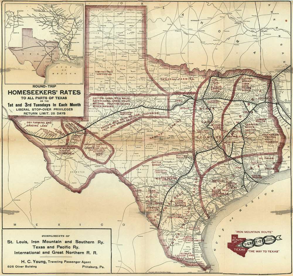
This is a 1909 Poole Brothers map of Texas promoting settlement and investment in Texas. Depicting the state in detail, railroad routes across the state are highlighted and maroon overprinting promotes the various agricultural and industrial regions. Farming and grazing land, areas suited for raising livestock, and regions suited for specific crops, such as corn, melons, grain, cotton, and wheat are identified. In a bid to further diversify opportunities available to a newcomer in Texas, the state's artesian well belt is noted, as are several irrigated districts. Of course, the oil and gas districts are labeled, as this map was published in the first decade of the Texas oil boom, which most historians say began in 1901 with the discovery near Beaumont. To further promote the idea of seeking one's fortune in Texas, a block-lettered ad promotes round-trip train tickets at 'homeseekers' rates' on the first and third Tuesday of every month. The coup-de-grace is provided by an inset map detailing railroad connections to Texas from Omaha, Kansas City, and St. Louis situated in the upper left corner, which further emphasizes the ease with which the 'homeseeker' could move to Texas and find their fortune.
Publication History and Census
This map was created and published by Poole Brothers in 1909 for the St. Louis, Iron Mountain and Southern Railway. The present edition was distributed by H.C. Young, a traveling passenger agent for the St. Louis, Iron Mountain and Southern Railway, the Texas and Pacific Railway, and the International and Great Northern Railway based in Pittsburgh. We have located two other examples of this map, one in the collection at the Library of Congress and the other at the University of Texas at Arlington, and each features different advertisements, both of which are realty companies.Cartographer
Poole Brothers (1878 - 1968) were a Chicago based firm active in the late 19th and early 20th century with an initial focus on promotional railroad maps. Poole Brothers was founded by George Amos Poole (March 20, 1843 – September 7, 1918). In 1868, Poole, along with his uncle William H. Rand (1828 - 1915) and Andrew McNally (1836 - 1904), purchased the Chicago Tribune's job printing plant and formed the firm Rand McNally. In 1878, he left Rand McNally to form, with his brother William H. Poole, Poole Brothers, a direct competitor to Rand McNally for the lucrative railroad business. Like many of its competitors, Poole Brothers maintained an office on Chicago's Printer's Row (downtown Loop district). Their earliest known work is an 1880 map of Yellowstone National Park. In 1887, Poole Brothers, Andrew McNally, and several others formed the United Typothetae of America, a master printers association. In 1848, they were cited, along with Rand McNally and George Cram, by the Federal Trade Commission for price fixing. Their earliest known work is an 1880 map of Yellowstone National Park. Afterward they went on to produce a vast range of maps and other print products including tickets, cards, coupons, and restaurant menus. In time Poole Brothers merged with Newman-Randolph, which was then acquired by the American Can Company in the early 1960s. The American Can Company liquidated its printing concerns later in the same decade. More by this mapmaker...
Condition
Average. Map is printed on thin acidic paper and has been laid down on archival tissue and stabilized. Some areas of infill and discoloration along central fold lines. Exhibits edge repairs and reinstatement.
References
OCLC 16525003.