1951 Metsker Map of Island County, Washington
IslandCo-metsker-1951$350.00


Title
Metsker's Map of Island County, Washington.
1951 (dated) 28.5 x 17.75 in (72.39 x 45.085 cm) 1 : 84480
1951 (dated) 28.5 x 17.75 in (72.39 x 45.085 cm) 1 : 84480
Description
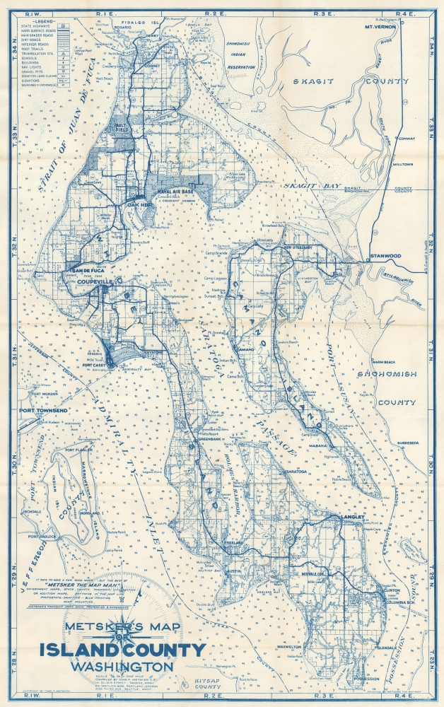
This is a 1951 Metsker map of Island County, Washington. The map captures the scenic island county as it emerged as a major regional military center and tourist destination.
A Closer Look
The map depicts the region from Fidalgo Island and Similk Bay to Possession and Kitsap County, and from Port Townsend and the Strait of Juan de Fuca to Snohomish County, thus including both Whidbey Island and Camano Island. Island County is composed entirely of islands, of which there are 9, with Whidbey and Camano being the largest. Towns are labeled throughout, along with the Naval Air Base and Ault Field. Admiralty Inlet, Saratoga Passage, Holmes Harbor, Possession Sound, and Skagit Bay are identified. This being a road map, major and minor roads are included.Publication History and Census
This map was created and published by Charles Metsker and Metsker Maps in 1951. Metsker Maps published editions of their county maps series beginning in the 1930s and continuing into the 1980s or 1990s. We've seen cataloged examples of the Metsker Map of Island County dating from every decade within that range, although we have not found a cataloged example of the present edition. Examples of various editions appear on the market from time to time.Cartographer
Charles Frederick Metsker (December 5, 1881 - October 6, 1966) was an American cartographer and publisher. Born in Douglas County, Kansas, Metsker's family moved to Winlock, Washington, in 1900. Metsker began publishing maps in 1901 in Tacoma, Washington. By the 1920s he was advertising as 'Metsker the Map Man' in Washington and Oregon newspapers. He opened a brick and mortar store in 1950 in Seattle and sold Township maps and atlases and County maps. He married Minnie B. Clevenger (1888 - 19xx) on May 11, 1905, with whom he had two children. They divorced sometime between 1910 and 1920. He married Elizabeth F. Metsker (1899 - 1982) on November 6, 1922, with whom he had a daughter. He retired in 1948 when he turned the business over to his son. He died in McMinnville, Oregon, at the age of 84. Metsker Maps joined forces with the Kroll Map Company, another Seattle-based mapmaker, in 1980. Metsker Maps continues to operate in Seattle to this day, where they can be visited at the Pike Place Market in the Sanitary Market Building. More by this mapmaker...
Condition
Very good. Light wear along original fold lines. Closed edge tear professionally repaired on verso. Accompanied by original binder.