This item has been sold, but you can get on the Waitlist to be notified if another example becomes available, or purchase a digital scan.
1683 Mallet Map of California as an Island
IsleCalifornie-mallet-1683$250.00

Title
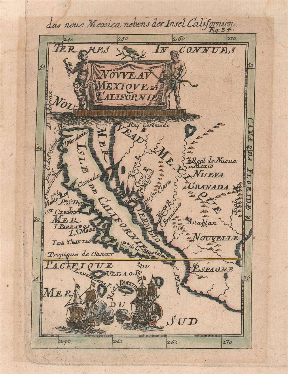
das neue Mexica nebens der Insel Californien. / Nouveau Mexique et Californie.
1683 (undated) 6.5 x 4.5 in (16.51 x 11.43 cm) 1 : 35000000
1683 (undated) 6.5 x 4.5 in (16.51 x 11.43 cm) 1 : 35000000
Description
This is a 1683 Alain Manesson Mallet map of California as an island in its much scarcer German edition. The map depicts the region from the Pacific Ocean to Santa Fe (Real de Nueva Mexico) and the Suala Mountains and from Rey Coromedo to Mexico (Nouvelle Espagne). One of the most celebrated miniature maps of California as an island, Mallet employs a unique projection, making this an essential piece for any collector of maps illustrating California as an island. Most maps that include California as an island depict the entirety of North America, making a map of this scope a rare find, and this is one of the earliest.
Insular California
The idea of an insular California first appeared as a work of fiction in Garci Rodriguez de Montalvo's c. 1510 romance Las Sergas de Esplandian, where he writesKnow, that on the right hand of the Indies there is an island called California very close to the side of the Terrestrial Paradise; and it is peopled by black women, without any man among them, for they live in the manner of Amazons.Baja California was subsequently discovered in 1533 by Fortun Ximenez, who had been sent to the area by Hernan Cortez. When Cortez himself traveled to Baja, he must have had Montalvo's novel in mind, for he immediately claimed the 'Island of California' for the Spanish King. By the late 16th and early 17th century ample evidence had been amassed, through explorations of the region by Francisco de Ulloa, Hernando de Alarcon, and others, that California was in fact a peninsula. Nonetheless, by this time other factors were in play. Francis Drake had sailed north and claimed Nova Albion, modern day Washington or Vancouver, for England. The Spanish thus needed to promote Cortez's claim on the 'Island of California' to preempt English claims on the western coast of North America. The significant influence of the Spanish crown on European cartographers spurred a major resurgence of the Insular California theory.
Printed Maps with Insular California
The earliest surviving map to illustrate California as an island is considered to be the 1622 title page to the Michiel Colijn edition of Antonio Herrera's Descriptio Indiae Occidentalis. Even so, the insular California convention formally dates to 1620, when the Dutch seized a Spanish ship transporting the account of Friar Antonio de la Ascension, which was intended for the Council of the Indies. In that work, the good Friar apparently asserted his strong belief that California is insular - although his sources are unknown. While the Friar Antonio account is now lost, a legend on the Henry Briggs map of 1625 conveys this information and that Briggs saw such a map in 1622. Colijn may have seen the same map when preparing this Herrera title page.Publication History
This map was created by Alain Manesson Mallet and published in the German edition of his work Description de l'univers in 1683.Cartographer
Alain Manesson Mallet (1630-1706) was a French cartographer, grammarian, engineer and mathematician, active in the mid to late 17th century. Despite being born in France, as a young man Mallet joined the Portuguese - yes Portuguese - army where he served as a Sergeant-Major. Later he was able to levy his war experience into a career as Inspector of Fortifications for Louis XIV of France. It was in this position, where his work entailed examining and sketching various fortresses, that Mallet developed his cartographic interests. His most important work is his monumental five volume opus Description de L'Univers, published in 1683. This impressive work described the cultures, governments, lands, and customs of all the known peoples of the earth and included numerous maps and engravings. At the time, the Description was the largest and most comprehensive work of its kind ever published. A year later, in 1684, he published his 3 volume Les Travaux de Mars ou l'Art de la Guerre. Mallet is also known for his invention of the "dumpy bubble", a telescopic sight incorporating a level bubble used for surveying and astronomical observations. More by this mapmaker...
Condition
Very good. Even overall toning. Light soiling. Blank on verso.
References
OCLC 80912878.