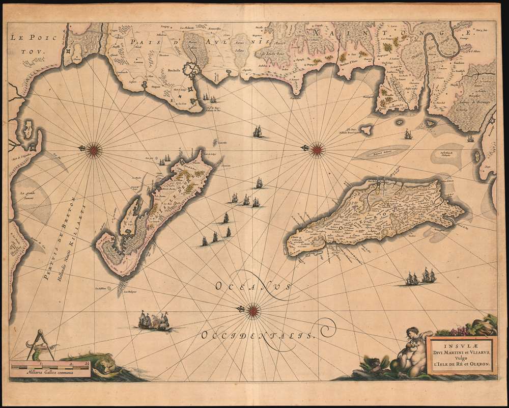
1649 Blaeu Map of the isles De Re and Oleron, France
IsleDeRe-blaeu-1649$600.00

Title
Insulae Divi Martini et Uliarus, Vulgo l’Isle de Re et Oleron.
1649 (undated) 15.5 x 21 in (39.37 x 53.34 cm) 1 : 170000
1649 (undated) 15.5 x 21 in (39.37 x 53.34 cm) 1 : 170000
Description
An exquisite 1649 Blaeu map of the La Rochelle region of western coastal France, including the Isle de Re and the Isle de Oleron. The centrally depicted, largely Protestant city of La Rochelle was a port of prime importance for Atlantic exploration and trade until the religious wars of the 17th century. The east-oriented map shows coastal forts, roads, wetlands and salt plains. In many respects it also resembles a chart, with rhumb lines, three fine compass roses, and navigational hazards such as shallows marked. The map's rich decoration alludes to the region's maritime importance, with nineteen ships, a sea monster, and a beautiful cartouche portraying a mermaid nursing a mer-infant. The quality of the engraving is typical of the superb standard set by the younger Blaeu, this example being embellished with delicate contemporary color.
Publication History
This is one of the maps added by Johannes Blaeu to the Atlas Novus after his inheritance of his father's business; consequently it is scarcer than many of the maps produced for the Blaeu atlases.Cartographer
Joan (Johannes) Blaeu (September 23, 1596 - December 21, 1673) was a Dutch cartographer active in the 17th century. Joan was the son of Willem Janszoon Blaeu, founder of the Blaeu firm. Like his father Willem, Johannes was born in Alkmaar, North Holland. He studied Law, attaining a doctorate, before moving to Amsterdam to join the family mapmaking business. In 1633, Willem arranged for Johannes to take over Hessel Gerritsz's position as the official chartmaker of the Dutch East India Company, although little is known of his work for that organization, which was by contract and oath secretive. What is known is his work supplying the fabulously wealthy VOC with charts was exceedingly profitable. Where other cartographers often fell into financial ruin, the Blaeu firm thrived. It was most likely those profits that allowed the firm to publish the Theatrum Orbis Terrarum, sive, Atlas Novus, their most significant and best-known publication. When Willem Blaeu died in 1638, Johannes, along with his brother Cornelius Blaeu (1616 - 1648) took over the management of the Blaeu firm. In 1662, Joan and Cornelius produced a vastly expanded and updated work, the Atlas Maior, whose handful of editions ranged from 9 to an astonishing 12 volumes. Under the brothers' capable management, the firm continued to prosper until the 1672 Great Amsterdam Fire destroyed their offices and most of their printing plates. Johannes Blaeu, witnessing the destruction of his life's work, died in despondence the following year. He is buried in the Dutch Reformist cemetery of Westerkerk. Johannes Blaeu was survived by his son, also Johannes but commonly called Joan II, who inherited the family's VOC contract, for whom he compiled maps until 1712. More by this mapmaker...
Source
Blaeu, W., Atlas Novus, (Amsterdam: Blaeu) 1642.
The classic Dutch atlas, whose publication ushered in the Dutch golden age of cartography. Willem Jansz Blaeu had been, since 1604, producing engraved maps for sale; these were separate issues (and all consequently extremely rare) until the publishing of Blaeu's Appendix in 1630 and 1631, which also included a number of maps purchased from the widow of Jodocus Hondius, (for example his famous iteration of John Smith's map of Virginia.) In 1634, he announced his intention to produce a new world atlas in two volumes, entitled Theatrum Orbis Terrarum, sive Atlas Novus (Théâtre du Monde ou Nouvel Atlas) (in an effort to invoke the successful work of the same title produced by Ortelius the previous century, while reinforcing the notion of it being a new work.) This work was published first in German in 1634, followed by Latin, Dutch and French editions in 1635. Blaeu's maps have always been noted for the quality of their paper, engraving and fine coloring, and this was the intent from the very start. The 1634 announcement of the upcoming work described it: 'All editions on very fine paper, completely renewed with newly engraved copperplates and new, comprehensive descriptions.' (van der Krogt, p,43) Many of the most beautiful and desirable maps available to the modern collector were printed and bound in Blaeu's atlases. Willem's son, Joan, would go on to add further volumes to the Atlas Novus, concurrently printing new editions of the first two volumes with additional maps, in effect making these new editions an entirely new book. Under Joan there would be nine Latin editions, twelve French, at least seven Dutch, and two German. This exceedingly successful work would be the mainstay of the Blaeu firm until 1661, at which point the work was supplanted by Joan Blaeu's masterwork Atlas Maior in 1662.
Condition
Very good. Uniformly toned. Some marginal mends not affecting printed image.
References
OCLC 158673831.