1881 U.S.C.G.S. Nautical Chart of the New England Coast: Boston, Cape Ann, Maine
IsleHautCapeCod-uscgs-1881$600.00

Title
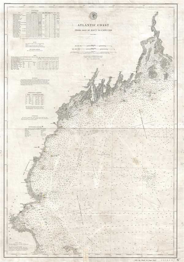
Atlantic Coast from Isle au Haut to Cape Cod.
1881 (dated) 32 x 22 in (81.28 x 55.88 cm) 1 : 400000
1881 (dated) 32 x 22 in (81.28 x 55.88 cm) 1 : 400000
Description
This is an 1881 U.S. Coast and Geodetic Survey nautical chart or maritime map of the northern Atlantic coastline of the United States. The map depicts the Atlantic coastline from the Isle au Haut and Penobscot Bay, Maine to Cape Cod and Kingston, Massachusetts and from the coastline into the Atlantic Ocean as far as Cashe's Ledge and Jeffrey's Bank. A highly detailed depiction of the coastline, all of the river mouths islands, and islets are illustrated in detail. Innumerable depth soundings are included all along the coast. Lighthouses have all been shaded yellow. Cities and towns along the coast are labeled, including Bangor, Kennebunkport, and Portland, Maine; Portsmouth, New Hampshire; and Newburyport, Salem, and Boston, Massachusetts. A table of light houses, with latitude and longitude, character of the light, the time between flashes, the distance at which the light is visible (in nautical miles) and other information included is situated on the upper left. Information about buoys, 'life saving stations', tides, and soundings, and other information important to the mariner is included below the table containing the information about light houses.
This map was published as plate no. 1777 by the U.S. Coast and Geodetic Survey in March 1881, Carlile Pollock Patterson, Superintendent.
This map was published as plate no. 1777 by the U.S. Coast and Geodetic Survey in March 1881, Carlile Pollock Patterson, Superintendent.
CartographerS
The Office of the Coast Survey (1807 - present) founded in 1807 by President Thomas Jefferson and Secretary of Commerce Albert Gallatin, is the oldest scientific organization in the U.S. Federal Government. Jefferson created the "Survey of the Coast," as it was then called, in response to a need for accurate navigational charts of the new nation's coasts and harbors. The spirit of the Coast Survey was defined by its first two superintendents. The first superintendent of the Coast Survey was Swiss immigrant and West Point mathematics professor Ferdinand Hassler. Under the direction of Hassler, from 1816 to 1843, the ideological and scientific foundations for the Coast Survey were established. These included using the most advanced techniques and most sophisticated equipment as well as an unstinting attention to detail. Hassler devised a labor intensive triangulation system whereby the entire coast was divided into a series of enormous triangles. These were in turn subdivided into smaller triangulation units that were then individually surveyed. Employing this exacting technique on such a massive scale had never before been attempted. Consequently, Hassler and the Coast Survey under him developed a reputation for uncompromising dedication to the principles of accuracy and excellence. Unfortunately, despite being a masterful surveyor, Hassler was abrasive and politically unpopular, twice losing congressional funding for the Coast Survey. Nonetheless, Hassler led the Coast Survey until his death in 1843, at which time Alexander Dallas Bache, a great-grandson of Benjamin Franklin, took the helm. Bache was fully dedicated to the principles established by Hassler, but proved more politically astute and successfully lobbied Congress to liberally fund the endeavor. Under the leadership of A. D. Bache, the Coast Survey completed its most important work. Moreover, during his long tenure with the Coast Survey, from 1843 to 1865, Bache was a steadfast advocate of American science and navigation and in fact founded the American Academy of Sciences. Bache was succeeded by Benjamin Pierce who ran the Survey from 1867 to 1874. Pierce was in turn succeeded by Carlile Pollock Patterson who was Superintendent from 1874 to 1881. In 1878, under Patterson's superintendence, the U.S. Coast Survey was reorganized as the U.S. Coast and Geodetic Survey (C & GS) to accommodate topographic as well as nautical surveys. Today the Coast Survey is part of the National Oceanic and Atmospheric Administration or NOAA as the National Geodetic Survey. More by this mapmaker...
Carlile Pollock Patterson (August 24, 1816 - August 15, 1881) was the fourth superintendent of the United States Coast Survey. Born in Shieldsboro (now Bay St. Louis), Mississippi and the son of the American naval officer Daniel Todd Patterson (1786 - 1839), Carlile joined the navy as a midshipman in 1830. He graduated from Georgetown College in Kentucky as a civil engineer in 1838 and was attached to the U.S. Coast Survey from 1838 - 1841. In 1841, he was commissioned as a lieutenant. As commander of the Coast Survey schooner Phoenix, Patterson led the first USCS hydrographic expedition of the Gulf of Mexico in 1845. Patterson resigned from the Navy in 1853. At the outbreak of the Civil War in 1861, Patterson returned to federal service as a civilian hydrographic inspector in the Coast Survey, in charge of the charting and survey work. He was appointed as the Superintendent of the U.S. Coast and Geodetic Survey in 1874, a post he held until his death. Learn More...
Condition
Good. Verso repair of centerfold separation. Closed tears professionally repaired on verso. Blank on verso.
References
OCLC 317743279.