This item has been sold, but you can get on the Waitlist to be notified if another example becomes available, or purchase a digital scan.
1794 Laurie and Whittle Nautical Chart or Map of the Isle Rodrigues, Mauritius
IsleRodrigues-lauriewhittle-1794$237.50

Title
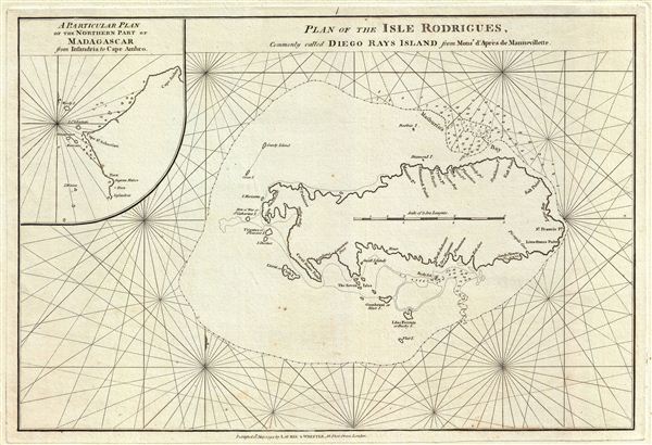
Plan of the Isle Rodrigues, Commonly called Diego Rays Island.
1794 (dated) 13.5 x 20 in (34.29 x 50.8 cm) 1 : 120000
1794 (dated) 13.5 x 20 in (34.29 x 50.8 cm) 1 : 120000
Description
This is a fine example of Laurie and Whittle's 1794 nautical chart or maritime map of the Isle Rodrigues or Diego Rays Island, part of the Mascarene Islands in the Indian Ocean. It covers the entire island along with surrounding smaller islands, including Diamond Island, Crab Island, the Seven Isles, Booby Island, among others. Mathurin Bay (Port Mathurin) is also noted. An inset in the upper left quadrant of the map features a plan of the northern part of Madagascar, from Infandria to Cape Ambro. The Island, believed to have been discovered ancient Arabs mariners, was first mapped in Europe by Alberto Cantino in 1502 and called Dina Morare. In 1528, the Island was renamed after the Portuguese explorer Dom Diego Rodrigues and has since retained the name. Although the Rodrigues did not see many visitors, 17th century Dutch seafarers did visit the island for fresh food supplies. Later, during the 18th century, the French introduced African slaves in an attempt to develop farming and stockbreeding. Slavery was abolished when the British took over the island in 1809.
This chart is cartographically derived from Jean-Baptiste d'Apres de Mannevillette's similar chart issued for the 1745 Neptune Oriental. It was published by Laurie and Whittle from their offices at 53 Fleet Street, London, on May 12, 1794.
This chart is cartographically derived from Jean-Baptiste d'Apres de Mannevillette's similar chart issued for the 1745 Neptune Oriental. It was published by Laurie and Whittle from their offices at 53 Fleet Street, London, on May 12, 1794.
Cartographer
Laurie and Whittle (fl. 1794 - 1858) were London, England, based map and atlas publishers active in the late 18th and early 19th century. Generally considered to be the successors to the Robert Sayer firm, Laurie and Whittle was founded by Robert Laurie (c. 1755 - 1836) and James Whittle (1757-1818). Robert Laurie was a skilled mezzotint engraver and is known to have worked with Robert Sayer on numerous projects. James Whittle was a well-known London socialite and print seller whose Fleet Street shop was a popular haunt for intellectual luminaries. The partnership began taking over the general management of Sayer's firm around 1787; however, they did not alter the Sayer imprint until after Sayer's death in 1794. Apparently Laurie did most of the work in managing the firm and hence his name appeared first in the "Laurie and Whittle" imprint. Together Laurie and Whittle published numerous maps and atlases, often bringing in other important cartographers of the day, including Kitchin, Faden, Jefferys and others to update and modify their existing Sayer plates. Robert Laurie retired in 1812, leaving the day to day management of the firm to his son, Richard Holmes Laurie (1777 - 1858). Under R. H. Laurie and James Whittle, the firm renamed itself "Whittle and Laurie". Whittle himself died six years later in 1818, and thereafter the firm continued under the imprint of "R. H. Laurie". After R. H. Laurie's death the publishing house and its printing stock came under control of Alexander George Findlay, who had long been associated with Laurie and Whittle. Since, Laurie and Whittle has passed through numerous permeations, with part of the firm still extant as an English publisher of maritime or nautical charts, 'Imray, Laurie, Norie and Wilson Ltd.' The firm remains the oldest surviving chart publisher in Europe. More by this mapmaker...
Source
Laurie, R., and Whittle, J., The East-India Pilot, or Oriental Navigator, on One Hundred and Eighteen Plates: Containing a Complete Collection of Charts and Plans, &c., &c. for the Navigation not only of the Indian and China Seas, but of those also between England and the Cape of Good-Hope; Improved and Chiefly Composed from the Last Work of M. D'Apres de Mannevillette; with Considerable Additions, from Private Manuscripts of the Dutch, and from Draughts and Actual Surveys Communicated By Officers of the East-India Company A New Edition, Containing One Hundred and Five Charts. (London: Laurie and Whittle) 1797.
Condition
Very good. Original platemark visible.