This item has been sold, but you can get on the Waitlist to be notified if another example becomes available, or purchase a digital scan.
1749 Vaugondy Map of Cape Breton Island, Canada
IsleRoyale-vaugondy-1749$137.50

Title
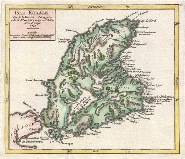
Isle Royale. Par le Sr. Robert de Vaugondy, Fils de Mr. Robert Géog. ord du Roi
1749 (dated) 7 x 8 in (17.78 x 20.32 cm) 1 : 1350000
1749 (dated) 7 x 8 in (17.78 x 20.32 cm) 1 : 1350000
Description
This is a hand colored 1749 Didier Robert de Vaugondy map of Cape Breton Island. Specific maps of Cape Breton Island are extremely rare. The map depicts the whole of Cape Breton Island from Port Hawkesbury to Bay Saint Lawrence and the extreme northeastern coast of Nova Scotia (Accadie).
The map is titled Isle Royale because in 1749 Cape Breton Island was the French colony Isle Royale. Isle Royale was part of New France from 1713 to 1763. Isle Royale came into French possession following the War of the Spanish Succession. The map depicts the colonial capital of Louisbourg, which was founded in 1713. Isle Royale became a battleground in the wars between Britain and France for control of North America. The French built a fortress at Louisbourg, to protect their North American possessions and the fishermen who worked the seas around Isle Royale. During the wars between the British and the French in the 18th century, Louisbourg fell under siege twice, once in 1745, after which Isle Royale was returned to the French, and again in 1758 during the Seven Years' War. Isle Royale was officially ceded to Great Britain in 1763, when it became Cape Breton Island.
This map was published by Gilles Robert de Vaugondy in his Atlas Universel, Portatif et Militaire in the 1749 edition.
Cartographer
Robert de Vaugondy (fl. c. 1716 - 1786) was French may publishing from run by brothers Gilles (1688 - 1766) and Didier (c. 1723 - 1786) Robert de Vaugondy. They were map publishers, engravers, and cartographers active in Paris during the mid-18th century. The father and son team were the inheritors to the important Nicolas Sanson (1600 - 1667) cartographic firm whose stock supplied much of their initial material. Graduating from Sanson's maps, Gilles, and more particularly Didier, began to produce their own substantial corpus. The Vaugondys were well-respected for the detail and accuracy of their maps, for which they capitalized on the resources of 18th-century Paris to compile the most accurate and fantasy-free maps possible. The Vaugondys compiled each map based on their own geographic knowledge, scholarly research, journals of contemporary explorers and missionaries, and direct astronomical observation. Moreover, unlike many cartographers of this period, they took pains to reference their sources. Nevertheless, even in 18th-century Paris, geographical knowledge was limited - especially regarding those unexplored portions of the world, including the poles, the Pacific Northwest of America, and the interiors of Africa, Australia, and South America. In these areas, the Vaugondys, like their rivals De L'Isle and Buache, must be considered speculative or positivist geographers. Speculative geography was a genre of mapmaking that evolved in Europe, particularly Paris, in the middle to late 18th century. Cartographers in this genre would fill in unknown lands with theories based on their knowledge of cartography, personal geographical theories, and often dubious primary source material gathered by explorers. This approach, which attempted to use the known to validate the unknown, naturally engendered rivalries. Vaugondy's feuds with other cartographers, most specifically Phillipe Buache, resulted in numerous conflicting papers presented before the Academie des Sciences, of which both were members. The era of speculative cartography effectively ended with the late 18th-century explorations of Captain Cook, Jean Francois de Galaup de La Perouse, and George Vancouver. After Didier died, his maps were acquired by Jean-Baptiste Fortin, who in 1787 sold them to Charles-François Delamarche (1740 - 1817). While Delamarche prospered from the Vaugondy maps, he defrauded Vaugondy's window Marie Louise Rosalie Dangy of her rightful inheritance and may even have killed her. More by this mapmaker...
Source
Robert de Vaugondy, G., Atlas Portatif, Universel, et Militaire, (Paris: Vaugondy, Durand, Pissot) 1749.
Condition
Very good. Blank on verso. Original press mark visible.
References
Pedley, M. S., Bel et Utile, p. 213, 463.