
This item below is out of stock, but another example (left) is available. To view the available item, click "Details."
Details
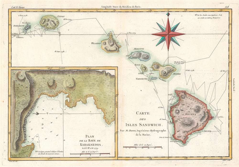
1788 Bonne Map of the Hawaii / Hawaiian Islands
$750.00
1788 Bonne Map of the Hawaii / Hawaiian Islands
IslesSandwich-bonne-1788-2$325.00

Title
Carte des Isles Sandwich.
1788 (undated) 9.5 x 14 in (24.13 x 35.56 cm) 1 : 900000
1788 (undated) 9.5 x 14 in (24.13 x 35.56 cm) 1 : 900000
Description
This is a 1788 Rigobert Bonne map of the Hawaiian Islands, a result of the third and final voyage of Captain James Cook. The map includes the entire archipelago: Hawaii, Maui, Lanai, Molokai, Oahu, Kauai, and Nihau. The route followed by Cook's expedition appears along with dates. An inset map of the Bay of Karakakooa is situated in the lower left.
After possibly being mistaken for a deity, Cook and his crew got into scuffles with the local population and attempted to kidnap Kalaniʻōpuʻu, the Hawaiian king. In the ensuing fracas, Cook was attacked and killed, along with four marines. Cook was still somewhat revered by the local people and his remains were given ceremonial treatment. His second in command, Charles Clerke, took command, but succumbed to tuberculosis only a few months later. The expedition eventually returned to London in October 1780, decimated by disease and demoralized by the death of Cook and Clerke. Nevertheless, the voyage collected important cultural, scientific, and geographic information and helped solidify Cook's reputation as one of the great explorers of his age.
Captain Cook, His Third Voyage, and Hawaii
By the time of his third long-distance voyage in 1776, James Cook was an experienced naval officer who captained two scientific expeditions to the Pacific. On his third voyage, after briefly stopping at the Hawaiian Islands in January 1778, Cook explored the west coast of North America up to the Bering Strait, where he discovered that he could not continue east or west. Cook and his crew returned to Hawaii in early 1779. It was here, at the Bay of Karakakooa, on the 14th of February 1779, that James Cook met his fate.After possibly being mistaken for a deity, Cook and his crew got into scuffles with the local population and attempted to kidnap Kalaniʻōpuʻu, the Hawaiian king. In the ensuing fracas, Cook was attacked and killed, along with four marines. Cook was still somewhat revered by the local people and his remains were given ceremonial treatment. His second in command, Charles Clerke, took command, but succumbed to tuberculosis only a few months later. The expedition eventually returned to London in October 1780, decimated by disease and demoralized by the death of Cook and Clerke. Nevertheless, the voyage collected important cultural, scientific, and geographic information and helped solidify Cook's reputation as one of the great explorers of his age.
Publication History and Census
This map was drawn by Rigobert Bonne and published in 1778. We note six examples cataloged in OCLC: Princeton University, the Library of Congress, DePaul University, the Birmingham Public Library, the University of Oregon, and the Bayerische Staatsbibliothek.CartographerS
Rigobert Bonne (October 6, 1727 - September 2, 1794) was one of the most important French cartographers of the late 18th century. Bonne was born in Ardennes à Raucourt, France. He taught himself mathematics and by eighteen was a working engineer. During the War of the Austrian Succession (1740 - 1748) he served as a military engineer at Berg-op-Zoom. It the subsequent years Bonne became one of the most respected masters of mathematics, physics, and geography in Paris. In 1773, Bonne succeeded Jacques-Nicolas Bellin as Royal Cartographer to France in the office of the Hydrographer at the Depôt de la Marine. Working in his official capacity, Bonne compiled some of the most detailed and accurate maps of the period - most on an equal-area projection known erroneously as the 'Bonne Projection.' Bonne's work represents an important step in the evolution of the cartographic ideology away from the decorative work of the 17th and early 18th century towards a more scientific and practical aesthetic. While mostly focusing on coastal regions, the work of Bonne is highly regarded for its detail, historical importance, and overall aesthetic appeal. Bonne died of edema in 1794, but his son Charles-Marie Rigobert Bonne continued to publish his work well after his death. More by this mapmaker...
Captain James Cook (7 November 1728 - 14 February 1779) is a seminal figure in the history of cartography for which we can offer only a cursory treatment here. Cook began sailing as a teenager in the British Merchant Navy before joining the Royal Navy in 1755. He was posted in America for a time where he worked Samuel Holland, William Bligh, and others in the mapping of the St. Lawrence River and Newfoundland. In 1766 Cook was commissioned to explore the Pacific and given a Captaincy with command of the Endeavour. What followed were three historic voyages of discovery, the highlights of which include the first European contact with eastern Australia, the discovery of the Hawaiian Islands (among many other Polynesian groups), the first circumnavigation of New Zealand, some of the first sightings of Antarctica, the first accurate mapping of the Pacific Northwest, and ultimately his own untimely death at the hands of angry Hawaiians in 1779. The influence of Cook work on the mapping and exploration of the Pacific cannot be understated. Learn More...
Condition
Very good.
References
OCLC 643751390.