This item has been sold, but you can get on the Waitlist to be notified if another example becomes available, or purchase a digital scan.
1697 Coronelli Map of the Islands of Tremiti
IsoleTremiti-coronelli-1697$450.00

Title
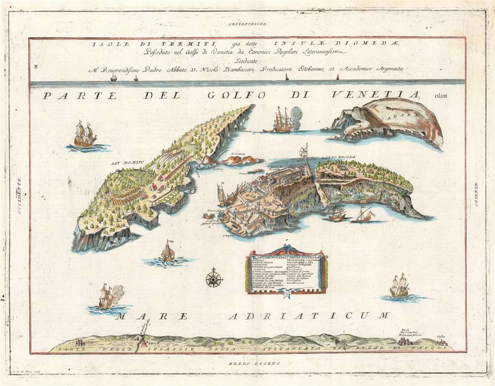
Isole di Tremiti, giá dette Insulae Dionedae, Possedute nel golfo di Venetia da Eanonici Regolari Lateranensi.
1697 (undated) 17.75 x 23.25 in (45.085 x 59.055 cm)
1697 (undated) 17.75 x 23.25 in (45.085 x 59.055 cm)
Description
This is the 1697 Vincenzo Coronelli map of the Isole Tremiti. These rocky islands have a long history of settlement, despite the frequent earthquakes that give the islands their name. The map shows both of the main islands - San Domino, and San Nicola - but also the uninhabited La Carara (Capraia) Credazza (Cretaccio) and the diminuitive La Vecchia (an island so small that while its name appears on digital maps the island itself seldom does.) San Domino is shown with cultivated fields, terraces, a church, and neatly ordered dwellings. San Nicola is dominated by its great, fortified monastery. At the bottom of the map is shown 'Part of the Beach of the Capitaniata of the Kingdom of Naples,' 'Capitaniata' being an early term for the Province of Foggia.
The islands have a somewhat longer history of involuntary settlement. In the first century CE, Augustus Caesar exiled his granddaughter Julia the Younger to one of these islands. In the 20th century, Mussolini interned prisoners there. And indeed, after he suppressed the Lateran Canons in 1783, Ferdinand IV of Naples would establish a penal colony in the Isole Tremiti.
In spite of the conditions which apparently make these islands suitable for monastic isolation and penal servitude, today they are part of Italy's National Parks, and enjoy what appears to be a thriving tourist trade, attracting divers in particular.
Monastic Solitude
At the time this map was prepared, the islands had for almost three hundred years been in the possession of the Canons Regular of the Lateran, a Catholic order of priests and lay brethren who famously defended the islands from Ottoman attack in the 16th century.The islands have a somewhat longer history of involuntary settlement. In the first century CE, Augustus Caesar exiled his granddaughter Julia the Younger to one of these islands. In the 20th century, Mussolini interned prisoners there. And indeed, after he suppressed the Lateran Canons in 1783, Ferdinand IV of Naples would establish a penal colony in the Isole Tremiti.
In spite of the conditions which apparently make these islands suitable for monastic isolation and penal servitude, today they are part of Italy's National Parks, and enjoy what appears to be a thriving tourist trade, attracting divers in particular.
Census and Publication History
This map appeared in editions of Coronelli’s Corso Geografico Universale in 1692. It was also included in his Atlante Veneto in 1697, and the presence of verso text indicates that this example is from the latter work. This edition of the map is catalogued separately only by the Biblioteca Nacional de Espana. The Atlante Veneto is well represented in institutional collections.Cartographer
Vincenzo Maria Coronelli (August 16, 1650 - December 9, 1718) was an important 17th-century cartographer and globe maker based in Venice. Coronelli was born the fifth child of a Venetian tailor. Unlikely to inherit his father's business, he instead apprenticed in Ravenna to a woodcut artist. Around 1663, Coronelli joined the Franciscan Order and, in 1671, entered the Venetian convent of Saint Maria Gloriosa dei Frari. Coronelli excelled in the fields of cosmography, mathematics, and geography. Although his works include the phenomenal Atlante Veneto and Corso Geografico, Coronelli is best known for his globes. In 1678, Coronelli was commissioned to make his first major globes by Ranuccio II Farnese, Duke of Parma. Each superbly engraved globe was five feet in diameter. Louis IV of France, having heard of the magnificent Parma globes, invited Coronelli to Paris, where from 1681-83 he constructed an even more impressive pair of globes measuring over 12 feet in diameter and weighing 2 tons each. The globes earned him the patronage of Louis XIV and privileged access to French cartographic information from Jesuit sources in the New World, particularly Louisiana. Coronelli returned to Venice and continued to publish globes, maps, and atlases, which were admired all over Europe for their beauty, accuracy, and detail. He had a particular fascination for the Great Lakes region, and his early maps of this area were unsurpassed in accuracy for nearly 100 years after their initial publication. He is also well known for his groundbreaking publication of the first accurate map depicting the sources of the Blue Nile. At the height of his career, Coronelli founded the world's first geographical society, the Accademia Cosmografica degli Argonauti, and was awarded the official title Cosmographer of the Republic of Venice. In 1699, in recognition of his extraordinary accomplishment and scholarship, Coronelli was also appointed Father General of the Franciscan Order. The great cartographer and globe maker died in Venice at the age of 68. His extraordinary globes can be seen today at the Bibliothèque Nationale François Mitterrand in Paris, Biblioteca Marciana in Venice, the National Library of Austria, the Globe Museum in Vienna, the Library of Stift Melk, the Special Collections Library of Texas Tech University, as well as lesser works in Trier, Prague, London, and Washington D.C. Coronelli's work is notable for its distinctive style, which is characterized by the high-quality white paper, dark intense impressions, detailed renderings of topographical features in profile, and numerous cartographic innovations. More by this mapmaker...
Source
Coronelli, V., Atlante Veneto, (Venice: Girolamo Albrizzi) 1697.
The Atlante Veneto was a Venetian cosmographic atlas issued by the Jesuit Minorite friar, geographer, and globe maker Vincenzo Maria Coronelli. The massive work consists of some 13 volumes in four parts. The first section focused on a general introduction to geography and included notes on various geographic systems and globes. The second part consisted of world maps from various periods and in various styles, including double-page maps of the continents and poles derived from his earlier globe work. The third part focused on hydrography and included nautically styled maps of important rivers, bays, oceans, lakes, and gulfs. The fourth and final section details exploration. The whole consisted of some 191 engraved charts and maps as well as an assortment of views and decorative plates. The atlas was conceived as a continuation of Blaeu's Atlas Major and, in many respects, follows Blaeu cartographically. Many of the other maps are derived from Coronelli's own earlier globe work and exhibit distinctly globe-like elements. Coronelli first issued the Atlante Veneto in 1691. A second edition was prepared and issued between 1695 and 1697. Most of the individual map plates remain identical and thus indistinguishable between editions. The maps of the Atlante Veneto are universally admired for their exquisite engraving and high production quality, including fine paper and premium inks. All examples were issued uncolored and have typically been left as such by dealers and collectors. Some of Coronelli's other works, including the Isolario dell' Atlante Veneto, Libro dei Globi, and Corso Geografico Universal, might reasonably considered amendments and expansions on the Atlante Veneto.
Condition
Very good. Some filled wormholes with virtually no loss to printed image. Toned at centerfold.
References
OCLC 733642225.