This item has been sold, but you can get on the Waitlist to be notified if another example becomes available, or purchase a digital scan.
1793 Cassini Wall Map / Case Map of Italy
Italia-cassini-1793$2,750.00

Title
Carta Generale dell'Italia Divisa Ne' Suoi Stati e Provincie.
1793 (dated) 79.5 x 76.5 in (201.93 x 194.31 cm) 1 : 617760
1793 (dated) 79.5 x 76.5 in (201.93 x 194.31 cm) 1 : 617760
Description
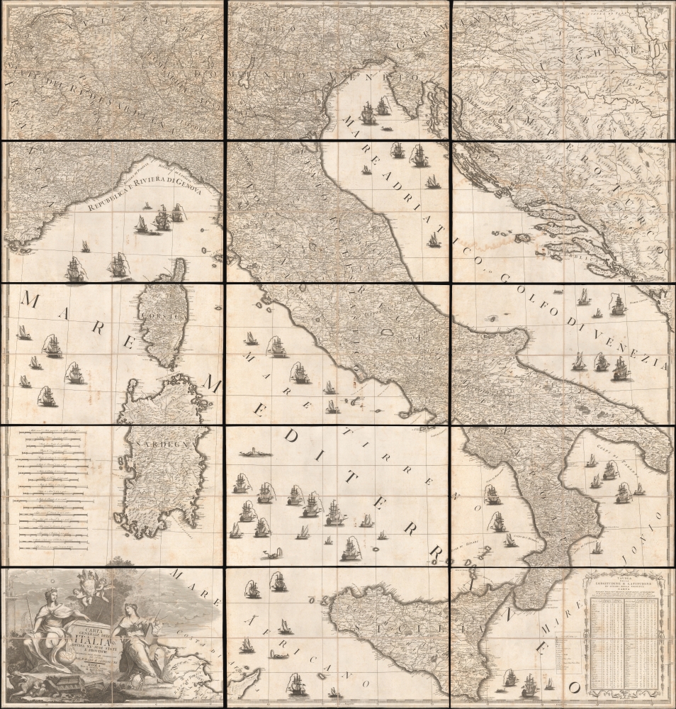
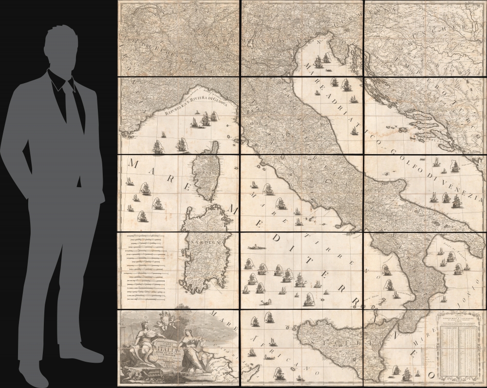
This is Giovanni Maria Cassini's monumental 1793 wall map of Italy. Considered the best map of Italy of the 18th century, this massive map is in 15 dissected sheets, each of which is sectionalized and laid on linen. Although Italy was an often-feuding network of loosely aligned kingdoms at this time, this map seems to suggest broad solidarity and emphasizes traditional hierarchical structures - likely a response to the ideals of the French Revolution (1789 - 1799) then destabilizing Europe.
In the lower left there is a dramatic allegorical cartouche, consisting of two female figures. The one on the left wears a corona muralis and sits (almost) on the Earth, likely representing the power of Rome or possibly the Holy See. Opposite this figure, on the right, another female figure represents the science of cartography. The babies, Romulus and Remus, suckle at a she-wolf in the lower right, an allusion to Rome. Two putti hold aloft the papal crest of Pope Pius VI (1717 - 1799).
A Closer Look
Coverage embraces peninsular Italy, extending north to reach Lake Geneva, Switzerland; south to include all of Sicily, Sardinia, and Corsica; east to cover the Adriatic Sea and Dalmatian coast. Ships of trade and war populate the waters, which are punctuated by occasional sea monsters. Cartographically, the map derives from J. B. B. D'Anville's (1697 - 1782) 1743 map of Italy, although with significant updates and revisions.In the lower left there is a dramatic allegorical cartouche, consisting of two female figures. The one on the left wears a corona muralis and sits (almost) on the Earth, likely representing the power of Rome or possibly the Holy See. Opposite this figure, on the right, another female figure represents the science of cartography. The babies, Romulus and Remus, suckle at a she-wolf in the lower right, an allusion to Rome. Two putti hold aloft the papal crest of Pope Pius VI (1717 - 1799).
Historical Context
As this map went to the presses, Italy was a patchwork of diverse states and territories, each with its own governance. The French Revolution was reverberating throughout Europe, with significant implications for the Italian states. The northern territories, like the Duchy of Milan and the Republic of Genoa, felt the direct impact of the neighboring French Revolutionary activities. Meanwhile, more centralized regions like the Papal States and the southern Kingdom of Naples sought to defend their sovereignty and limit the spread of revolutionary ideologies. Jacobin-inspired committees began to appear in several major Italian cities, advocating for reforms and questioning the existing feudal and monarchical orders. The political and social atmosphere was charged, with Italian states navigating the delicate balance between tradition and transformative ideas. In 1796, three years after this map was printed, Napoleon invaded Italy in the First Italian Campaign, formally bringing the French Revolution to Italy.Publication History and Census
This map was compiled by Giovanni Maria Cassini and printed in 1793 in Rome by the Calcografia Camerale. There is only one edition. The map is well represented in European institutions, particularly in Italy, where we see more than 5 examples. It is uncommon in both institutions and on the market outside of Europe.CartographerS
Giovanni Maria Cassini (1745 - 1824) was a Rome based Italian mathematician, globe maker, geographer, engraver, and cartographer active in the later part of the 18th and early 19th century. He was a disciple of Giovanni Battista Piranesi. He invented new form of projection used for an atlas of the kingdom of Naples issued by Giovanni Antonio Rizzi Zannoni. Cassini is best known as a globe maker and is considered the last of the great 18th century globe makers. His maps are distinctive for their fine engraving, dark strong impressions, and elaborate distinctive cartouche work. Unlike many map and atlas publishers of the period, Cassini did all of his own engraving work - this impregnating each map with his unmistakable style. Though he produced a significant corpus of well-regarded work, little is known of Cassini's personal life. G. M. Cassini is often mistakenly associated with the well-known French cartographic family of the same name, however, they are not related. More by this mapmaker...
Calcografia Camerale (1738 - 1870) is a Roman printer founded by Pope Benedict XIV in 1738, when it acquired the printing stock and plates of Giovanni Giacomo de Rossi (1627 - 1691), and his heirs. It is also known as the Calcografia della Camera Apostolica or Calcografia Romana. It operated as such until 1870, when it became the Regia Calcografia, changing its focus to printing from old-stock plates, of which it controls one of the largest archives in the world. The name changed again in 1945, to Calcografia Nazionale, and in 1975 to Istituto Nazionale per la Grafica. Today the institute and museum is housed in the monumental complex of Trevi Fountain, consisting of Palazzo Poli and neighboring Palazzo della Calcografia. Learn More...
Condition
Very good. Some sheets exhibit minor soiling and edge wear.
References
OCLC 9088188238. Borri, R., L'Italia nell'antica cartografia, 1477 - 1799, #239.