This item has been sold, but you can get on the Waitlist to be notified if another example becomes available, or purchase a digital scan.
1706 de la Feuille Map of Italy
Italy-lafeuille-1706$115.00

Title
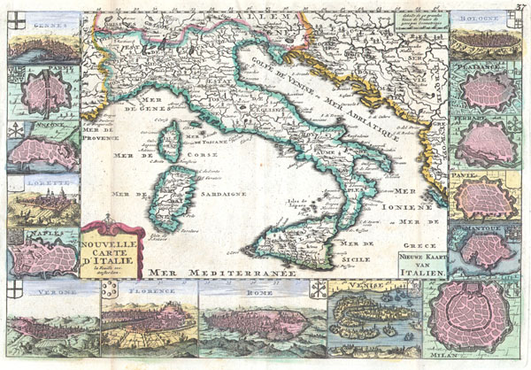
Nouvelle Carte D’Itlaie / Nieuwe Kaart van Italien.
1706 7 x 10 in (17.78 x 25.4 cm)
1706 7 x 10 in (17.78 x 25.4 cm)
Description
A very scarce, c. 1706, map of Italy issued by Daniel de La Feuille. Extends from Provence in the west to Serbia and the Island of Corfu in the east. Extends north as far as Switzerland and south as far as Sicily. Includes the islands of Corsica and Sardinia. Depicts the Italian peninsula and surrounding areas in considerable detail. The main map is surrounded by 15 maps of important Italiancities including: Gennes, Parme (Parma), Ancone, Lorette, Naples, Verone (Verona), Florence (Firenze), Rome, Venice, Milan, Mantoue (Mantua), Pavie, Ferrare, Platsance and Bolobne. Titles in lower right (in Dutch) and lower left (French) quadrants. This map was originally prepared for inclusion as chart no. 40 in the 1706 edition of De la Feuille's Les Tablettes Guerrières, ou Cartes choisies Pour la Commodité des Officiers et des Voyageurs, Contenant toutes les Cartes générales Du Monde, avec les particulieres des Lieux ou le Théatre de la Guerre se fait sentir en Europe..
Cartographer
Daniel de La Feuille (1640 - 1709) was born of Huguenot stock in Sedan (L'Ardennes), France. As a young man he apprenticed as a watchmaker. In 1663 La Feuille married Charlette Marlet, the daughter of a local carpenter. Twenty years later, in 1683, facing religious prosecution of Huguenots in France, the family fled to Amsterdam. By 1686 Daniel had become a burgher (citizen) of the city and established himself as an engraver, publisher, and art dealer. Not long after, in 1691, he was admitted into the Booksellers Guild. Though we are primarily concerned with his cartographic work here, his masterpiece is considered to be Devises et emblems, a collection of symbols and designs mostly likely intended as templates for silversmiths, engravers, and watchmakers. His cartographic work includes numerous individual maps and atlases, many of which continued to be published and republished well after his death in 1709. He was succeeded by his sons Jacob de la Feuille (1668 - 1719) and Paul de La Feuille (1688 - 1727). More by this mapmaker...
Condition
Very Good condition. Minor discoloration along the original folds – see photo. Minor fold separation limited to wide marginal region. Original plate-mark visible. Else clean and beautiful.