This item has been sold, but you can get on the Waitlist to be notified if another example becomes available, or purchase a digital scan.
1814 Rizzi-Zannoni Map of Italy
Italy-rizzizannoni-1814$750.00

Title
Italy from the Original Map by G. A. Rizzi-Zannoni.
1814 (dated) 41 x 18 in (104.14 x 45.72 cm)
1814 (dated) 41 x 18 in (104.14 x 45.72 cm)
Description
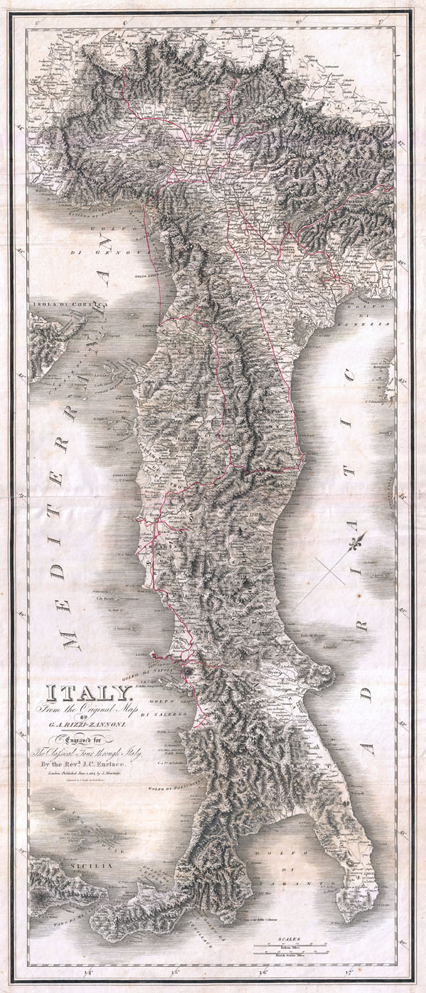
One of the most attractive maps of Italy to appear in the 19th century, this is the 1814 Mawman and Smith re-engraving of G. A. Rizzi-Zannoni's magnificent 1802 Nuova Carta dell'Italia. Only slightly smaller than Rizzi-Zannoni's map in the vertical dimension, Mawman has narrowed the map in the horizontal by reformatting the whole with a northwesterly orientation in which most of Sicily and Corsica are cropped out in order to draw the focus of the map more firmly to the peninsular mainland of Italy. The result is an intensely detailed map in which Rizzi-Zannoni's fine engraving work is preserved and in some cased improved upon by Smith's own careful hand.
At over 40 inches in height and 17 inches in width, this map is a spectacular display piece in its own right. The engraving throughout, the work of Smith, is magnificent with topography rendered in stunning profile. A red and drawn line shows the classicists' ideal tour through Italy. Entering Italy by crossing the Alps from France, the tour leads through Torino and Vercelli before heading northeast to visit Lake Como, from which the path then leads south to Milan and Genoa. Taking to ship at Genoa, our tourist skirts the coast of the Italian Riviera to land at Livorno before turning inland to Lucca and Florence (Firenze). From Florence the tour leads southward through central Italy to reach Rome and, ultimately, Naples. Returning along the same course the route once again passes through Rome but then heads eastward across the peninsula to Loretto on Italy's Adriatic coast. From Loretto the route passes northwards along an old Roman causeway to Parma, Lake Garda, and ultimately Padua and Venice. The more adventurous traveller can then continue northeast to Trento and finally eastwards into Greece.
Mawman planned his this reimagining of Rizzi-Zannoni's map at the request of the Reverend, J. C. Eustace, who planned to include it in his Classical Tour Through Italy, an early 19th century touring guide to the antiquities of Italy. Today Classical Tour through Italy rarely appears on the market, and in most cases does not contain this map, which appeared in only one edition. Moreover, this particular example does not correspond in format to any of the known examples of Classical Tour…, suggesting that it must have also been issued and sold independently by Mawman. This map is extremely scarce. We have been unable to identify any examples appearing in dealer catalogs or at auction in the last 30 years. Moreover, we have isolated only a single example in an institutional collection, that being, typically enough, in the collection of Rome's British School.
CartographerS
Giovanni Antonio Bartolomeo Rizzi Zannoni (September 2, 1736 - May 20, 1814) was an 18th century Italian cartographer active in Venice and Naples. Zannoni was born in Padua, Italy on September 2, 1736. Between 1749 and 1751 Zannoni studied Astronomy at the University of Padua under John Polen, a prominent astronomer of the period. After leaving the University, Zannoni was commissioned by the King of Poland, Augustus III, to map that country. Zannoni's subsequent survey is considered the first accurate triangulation of Poland. Afterwards Zannoni's services were in high demand and he traveled around much of Europe, working on various surveys in Denmark, Germany, Prussia, and Sweden. Around 1757 Zannoni was caught up in the hostilities surrounding the Seven Year War and, after one battle, was taken to Paris as a prisoner of war. Paris must have suited Zannoni for he remained for nearly 20 years, even taking service with the Paris Engineer's Office. It was also here in Paris the Zannoni developed the cartographic contacts that would lead to his most prolific cartographic publications, including the Atlas Moderne in conjunction with Lattre. In 1781, Zannoni was called to Naples by the Bourbon monarchy to help in the revision of the Charter of 1769. Afterwards he stayed on and produced a numerous important maps of the Kingdom of Naples. Zannoni is considered a careful and precise cartographer and his work, particularly the maps he made in Naples, have been praised by R.V. Tooley as 'remarkable for a marvelously minute attention to detail, and amply deserves the commendation passed upon it by Sir George Fordham' (Tooley, Maps and Mapmakers, 21). Zannoni would spend the remainder of his days in Naples and passed away on May 20, 1814. More by this mapmaker...
Joseph Mawman (fl. 1797 - 1827) was an English general interest publisher active in London during the early 19th century. Mawman published travel guides and narratives, classical works, natural history books, and literary editions as well as producing contract work for both individuals and institutions. Mawman's offices were established in the Poultry, London where he took over the established publishing firm of Edward and Charles Dilly in 1800. The offices were later relocated to Ludgate Street, also in London. Mawman, who nurtured friendships with various period luminaries, was well known and highly respected intelligence and publishing acumen. Mawman died in 1827. Learn More...
John Thomas Smith (1766 - 1833) was a well-known English engraver and artist active in London during the late 18th and early 19th century. Smith was the son of the another important English engraver Jacob Smith. John Smith studied engraving under Sherwin and worked for several years as a drawing master before publishing his first work, the 1781 Antiquities of London and its Environs. His best known work is the 1815 Ancient Topography of London which features thirty-two boldly etched plates in the style of Piranesi. In 1816 Smith took the prestigious position of the Keeper of Prints at the British Museum. One of Smith's most important achievements, though under-appreciated at the time, involved a series of paintings discovered in 1800 on the wainscoting of the House of Commons. When the paintings were revealed by carpenters doing a renovation on the building Smith happened to be on hand. He promptly copied the paintings before they were destroyed by the over-zealous workmen. Smith's drawings are the only work that preserves these unusual historical curiosities. Learn More...
Source
Eustace, J. C., The Classical Tour through Italy, 1814. (though ostensibly prepared for Eustace's book, this map it does not correspond to the size and format of any edition of Classical Tour and therefore is more likely a separately sold independently issued example)
Condition
Very good condition.
References
British School at Rome, S.609.4.ITA.5.