This item has been sold, but you can get on the Waitlist to be notified if another example becomes available, or purchase a digital scan.
1814 Thomson Map of Italy
Italy-thomson-1814-2$175.00

Title
Italy.
1814 (dated) 24 x 20 in (60.96 x 50.8 cm) 1 : 2200000
1814 (dated) 24 x 20 in (60.96 x 50.8 cm) 1 : 2200000
Description
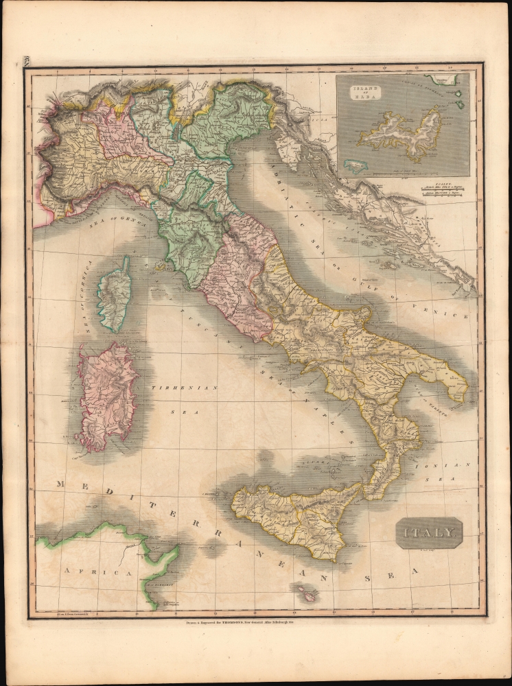
This is John Thomson's 1814 map of Italy. The map was issued in the wake of Napoleon's defeat and the dissolution of his influence in Italy - which at the same time marked the beginning of the Risorgimento.
A Closer Look
Thomson's map of Italy covers peninsular Italy from the Alps to Calabria as well as the adjacent islands of Sicily, Sardinia, and Corsica. Parts of northern Africa and the Dalmatian coast are also included. Relief is shown by hachure with towns, cities, and topographical features identified. The whole is beautifully engraved in the minimalist English style pioneered in the early part of the 19th century.Historical Context
Thomson issued this map shortly after the 1814 dissolution of Napoleon's empire and his exile to Elba, shown here as an inset in the upper right. Italy was divided between Austria, the Kingdom of Sardinia, and the Kingdom of the Two Sicilies. Nonetheless, the Italian campaigns of the French Revolutionary Wars destroyed the old structures of feudalism in Italy and introduced modern ideas and efficient legal authority, providing much of the intellectual and social capital that fueled Italian solidarity and the Risorgimento.Publication History and Census
This map was prepared and engraved in 1814 by Robert Scott for inclusion in the 1817 first edition of John Thomson's New General Atlas.CartographerS
John Thomson (1777 - c. 1841) was a Scottish cartographer, publisher, and bookbinder active in Edinburgh during the early part of the 19th century. Thomson apprenticed under Edinburgh bookbinder Robert Alison. After his apprenticeship, he briefly went into business with Abraham Thomson. Later, the two parted ways, John Thomson segueing into maps and Abraham Thomson taking over the bookbinding portion of the business. Thomson is generally one of the leading publishers in the Edinburgh school of cartography, which flourished from roughly 1800 to 1830. Thomson and his contemporaries (Pinkerton and Cary) redefined European cartography by abandoning typical 18th-century decorative elements such as elaborate title cartouches and fantastic beasts in favor of detail and accuracy. Thomson's principle works include Thomson's New General Atlas, published from 1814 to 1821, the New Classical and Historical Atlas of 1829, and his 1830 Atlas of Scotland. The Atlas of Scotland, a work of groundbreaking detail and dedication, would eventually bankrupt the Thomson firm in 1830, at which time their plates were sequestered by the court. The firm partially recovered in the subsequent year, allowing Thomson to reclaim his printing plates in 1831, but filed again for bankruptcy in 1835, at which time most of his printing plates were sold to A. K. Johnston and Company. There is some suggestion that he continued to work as a bookbinder until 1841. Today, Thomson maps are becoming increasingly rare as they are highly admired for their impressive size, vivid hand coloration, and superb detail. More by this mapmaker...
Robert Scott (November 13, 1771 - January 1841) was a Scottish engraver active in Edinburgh in the late 18th and early 19th centuries. He was born in Lanark and educated in Musselburgh. He apprenticed as an engraver under Andrew Robertson, of the Andrew Bell (1726 - 1809) engraving lineage. He married Bell's daughter, Ross Bell. He engraved maps and globes for James Kirkwood, John Thomson, and Archibald Fullerton, among others. His own apprentices included Thomas Brown, John Burnett, William Douglas, John Horsburgh, James Steward, and others. Scott was considered the finest Edinburgh engraver of his generation. (Worms, L., and Ashley Baynton-Williams, 'British Map Engravers') Learn More...
Baldwin and Cradock (fl. c. 1810 - 1860) were London based publishers working in the early to mid 19th century. They are best known for their publication of the Society for the Diffusion of Useful Knowledge's ground breaking subscription atlas. They also published John Thomson's magnificent New General Atlas from 1814 - c. 1820. In addition to their cartographic corpus, the firm had wide ranging publishing interests in many other areas, including books, broadsides, and an investment in Blackwoods Magazine. They had their offices at 47 Paternoster Row, London, England. This firm also published under the imprint Baldwin, Cradock, and Joy and Cradock and Joy. Learn More...
Source
Thomson, J., A New General Atlas, (Edinburgh: Baldwin, Cradock, Joy) 1817.
Thomson's New General Atlas was first published in 1817 and continued to be published until about 1821. This is the first of Thomson's major cartographic works and the atlas for which is most celebrated. The New General Atlas follows in the Edinburgh School, which eschews excessive decoration in favor of a more minimalistic fact-based cartographic vision, as established by John Pinkerton, Laurie and Whittle, John Cary, and others in the previous decades. The maps are notable for their massive scale, heavy stock, elegant color work, and easy-to-read typefaces. Although the atlas stopped being published after 1821, Thomson continued to offer 'supplementary' maps that could be tipped into the atlas as late as 1830, when he declared bankruptcy. The maps in the Thomson Atlas were engraved by Thomas Clerk, William Dassauville, Nathaniel Rogers Hewitt, James Kirkwood, Robert Kirkwood, John Menzies, George Menzies, Edward Mitchell, John Moffatt, Samuel John Neele, Robert Scott, and James Wyld.
Condition
Very good. Light wear along original centerfold. Verso repairs to centerfold separations.
References
Rumsey 1007.027. Phillips (Atlases) 731. Newberry Library, Ayer 135 T4 1817.