This item has been sold, but you can get on the Waitlist to be notified if another example becomes available, or purchase a digital scan.
1952 Dolph Map of Jacksonville, Florida
Jacksonville-dolph-1952$300.00


Title
Map of Jacksonville, Florida, and vicinity.
1952 (undated) 34 x 22 in (86.36 x 55.88 cm) 1 : 27000
1952 (undated) 34 x 22 in (86.36 x 55.88 cm) 1 : 27000
Description
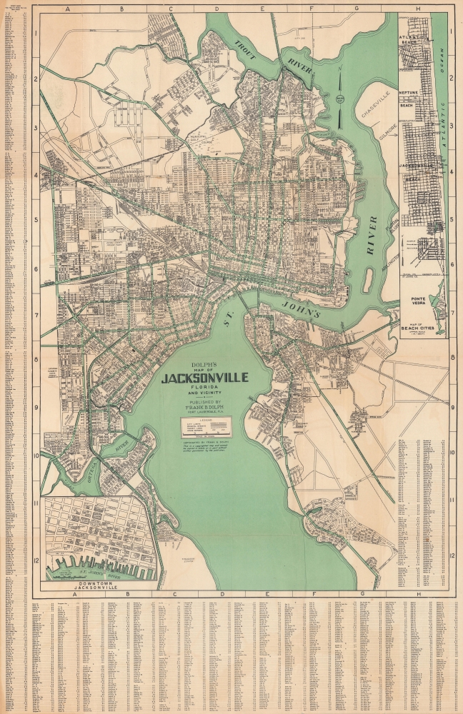
This is a large-format c. 1952 Dolph city map of Jacksonville, Florida, and its immediate environs highlighting the city's ongoing development.
The development of the city's infrastructure is evident through its dense rail lines and multiple bridges. The impressive rail network was crowned by Union Depot, the largest rail station in the South when completed in 1919. Two inset maps focus on downtown and coastal beach cities to the east, respectively.
Not far to the northeast, the c. 1920s Brentwood housing project, the first 'white' housing project in Jacksonville, is noted. The adjoining golf course, here as the 'Municipal Golf Course' was sold to developers in the 1960s to avoid the course's racial integration. After sitting dormant for years, a portion of it was later reopened as a 9-hole course.
A Closer Look
The map focuses on what is now Jacksonville's urban core, prior to consolidation: the area loosely delineated by the Ortega River, St. John's, and the Trout River. An alphanumeric grid corresponds to an index at left and bottom, with the final portion squeezed in at bottom-right, while a legend appears at center below the title.The development of the city's infrastructure is evident through its dense rail lines and multiple bridges. The impressive rail network was crowned by Union Depot, the largest rail station in the South when completed in 1919. Two inset maps focus on downtown and coastal beach cities to the east, respectively.
Public Housing and Segregated Neighborhoods
The 1920s brought a real estate boom to Jacksonville driven by railroad traffic en route to tourist destinations in South Florida, and the completion of the Dixie Highway. Several housing projects date from this period, including the Durkeeville Housing Project near center. This historic neighborhood was the result of the growing prosperity of Jacksonville's African American community.Not far to the northeast, the c. 1920s Brentwood housing project, the first 'white' housing project in Jacksonville, is noted. The adjoining golf course, here as the 'Municipal Golf Course' was sold to developers in the 1960s to avoid the course's racial integration. After sitting dormant for years, a portion of it was later reopened as a 9-hole course.
Publication History and Census
This map was published by Frank Dolph, based on an earlier c. 1930 map of the city produced by the New York-based firm Dolph and Stewart. It is undated, but the usage of Dolph instead of Dolph and Stewart indicates that it was published after the end of World War II (1939 - 1945), when Dolph relocated to Florida and changed the firm's name. Due to uncertainty over the date and the multiple editions of this map, there are ten OCLC listings under this title (including those listed as being issued by Seashole Funeral Parlors) with various editions held by eight institutions in the U.S.Cartographer
Frank B. Dolph (October 3, 1897 - November 26, 1975) was an American businessman and map publisher. Born in Great Neck, Long Island, New York, Dolph served as a Navy storekeeper during World War I. He began selling maps in 1919 after returning from England, likely for the George F. Cram Company, where he ultimately became an administrative aide. He also worked for the Rand McNally Company for some time before he founded his own map publishing firm, Dolph and Stewart, with his friend, sometime in the 1920s. Dolph and Stewart made maps throughout the 1920s and 1930s until they sold the firm in 1945 when Dolph decided to return to Florida. Dolph opened a new map publishing business, the Frank B. Dolph Map Co. in Ft. Lauderdale and published city plans of cities throughout the United States. Many of his maps were distributed by Chambers of Commerce or sold at newsstands. Real estate developers greatly appreciated his maps, those published by both the Dolph and Stewart Company and the Frank B. Dolph Company. Dolph retired as president of his firm around 1965, when he handed the business off to his son, Frank B. Dolph, Jr. Dolph worked with cartographer Theodore M. Politano for decades while operating the Frank B. Dolph Map Company. More by this mapmaker...
Condition
Very good. Some wear and creasing along fold lines. Uneven toning at bottom and top-left corner.
References
OCLC 5483951.