
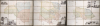
1763 Craskell and Simpson 3-Part Wall Map of Jamaica


This item has been sold.
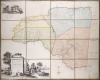
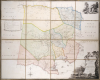
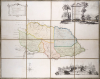
To the Right Honorable Robert Earl of Holdernesse, this map of the County of Cornwall, in the Island of Jamaica. (laid down from the papers, and under the direction of Henry Moore Esqr. His Majesty's Lieutenant Governor, and Commander in Chief of that Island, in the years 1756,-57,-58,-59,-60, and 61, and from a great number of actual surveys performed by the publishers) is humbly inscribed. / To the Right Honorable Wills Earl of Hillsborough, First Lord Commissioner of Trade and Plantations, this map of the County of Middlesex, in the Island of Jamaica. (laid down from the papers, and under the direction of Henry Moore Esqr. His Majesty's Lieutenant Governor and Commander in Chief of that Island in the years 1756,-57,-58,-59,-60, and 61, and from a great number of actual surveys performed by the publishers) is humbly inscribed. / To the Right Honorable George Grenville Esqr. First Lord Commissioner of the Treasury, Chancellor and under Treasurer of the Exchequers and c. and c. This map of the County of Surry, in the Island of Jamaica. (laid down from the papers and under the direction of Henry Moore Esqr. His Majesty's Lieutenant Governor and Commander in Chief of that Island in the years 1756,-57,-58,-59,-60, and 61, and from a great number of actual surveys performed by the publishers)is humbly inscribed.
Slave-suppression Masterplan.
Slave-suppression Masterplan.
A seminal production, this is the 1763 Craskell-Simpson map of Jamaica, in three parts. It is the first broadly accurate map of Jamaica and the template for most subsequent representations of the island until the Roberston map of 1804. More importantly, the Craskell-Simpson map is best understood as a response to Tacky's Rebellion (April 1760 - October 1761) and, as such, is a masterplan for slave suppression. The map was commissioned by Henry Moore (1714 - 1769), who also, ironically, commissioned the Ratzer plan of New York, then likewise on the cusp of rebellion. It is the only work (either written or graphic) that records virtually every plantation and pen (large farms) in Jamaica at the height of the island's sugar boom, when it was the most valuable possession of the British Empire.A Closer Look
The map consists of three large sheets representing the Jamaican counties established by Governor Henry Moore in 1758: Cornwall, Middlesex, and Surrey (Surry). The work is the result of a perambulatory (walking) survey of the island completed by Thomas Craskell and James Simpson from 1756 - 1761.The maps identify anchorages suitable for both large and small ships, as well as roads and parish borders, while also marking the locations of numerous types of settlements. These include estates devoted to sugar, coffee, cotton, ginger, and pimento, along with livestock pens and provision grounds - most labeled with the name of the proprietor or estate.
The map not only marks the locations of all Jamaica's estates, but also notes their sources of power (water, wind, cattle) and the types of crops (sugar, ginger, cotton, coffee, pimento). It records a total of 1,868agrarian estates, of which 605 grew sugar, while 1,263 focused upon theproduction of other staples. A close examination of these maps makes it possible to reconstruct how economic activities and settlement patterns were distributed across the parishes in the latter half of the 1750s. For many parishes, particularly those in the outer and intermediate regions, and even several in the core, these maps remain the sole surviving detailed record of such information.
The engraving, completed in London by Daniel Fournier, known as the 'Mad Geometer', is unique and interesting. Most of the map is engraved freehand, that is to say, without a rule or other device to ensure straight lines. Where usually an engraver would darken areas using stippling or hachure, here Fournier creates a dense cellular lattice. There are otherwise few straight lines, aside from the borders and lettering, to be found anywhere on the map. The result of this unique style is engraved images with a rich, naturalistic aesthetic we've not seen elsewhere.
Historical Context: Rebellion and Supression
The Craskell-Simpson Map was conceived as a master plan by Jamaica's colonial plantocracy to manage, suppress, and control the island's vast enslaved population. While most 18th-century West Indian maps served administrative and economic ends, none reflected the colonial anxiety of the age more vividly than this one. Mid-18th-century Jamaica was a volatile and deeply divided society - an island on the brink of upheaval. The enslaved population, largely of Coromantee (Akan) origin, vastly outnumbered the white inhabitants and often organized complex conspiracies infused with Obeah spiritual traditions. Though many plots were thwarted, the demographic imbalance and the isolation of plantation districts created a constant fear of rebellion. White Jamaicans lived in perpetual alarm, a fear so pervasive that Governor Edward Trelawny (1739 - 1752) anonymously called for the abolition of slavery, arguing that it endangered the colony's survival.It was within this fraught context that Henry Moore (1714 - 1769), a native Jamaican and scion of a powerful planter family, commissioned the Craskell-Simpson surveys. Serving as Lieutenant-Governor of Jamaica from 1756 to 1761, Moore was the de facto ruler in the absence of a permanent governor. Educated in Europe and well-versed in geography and military science, Moore was an unusually capable colonial administrator. In 1758, he reorganized Jamaica into three counties, initiated public works, and promoted infrastructural modernization. After his Jamaican tenure, Moore was made a baronet and appointed Governor of New York (1765 - 1769), where he deftly managed the Stamp Act crisis. Interestingly, Moore also sponsored Bernard Ratzer's celebrated survey of New York City and the New York-New Jersey boundary—making him a pivotal figure in both Jamaican and early American cartographic history.
During Moore's administration, the island faced its gravest crisis: Tacky's Rebellion (1760 - 1761), a widespread Coromantee-led uprising that erupted first in St. Mary Parish and later in Westmoreland and Hanover. The revolt spread rapidly through remote plantation zones while the island's military resources were depleted by the Seven Years' War (1756 - 1763). Despite limited manpower, Moore coordinated regular troops, militias, and Maroon allies with remarkable strategic precision, eventually suppressing the insurrection with brutal efficiency. Though victorious, he recognized that the island had narrowly escaped disaster - had the rebels secured Jamaica's western end, they might have established a lasting 'slave republic'
In the rebellion's aftermath, Moore ordered the Craskell-Simpson surveys not merely for routine civil administration, but as a comprehensive geographic tool for anticipating and containing future revolts. The maps recorded every plantation, road, and parish boundary - depicting both the infrastructure of colonial control and the potential pathways of insurrection. One poignant detail appears on the map of Cornwall County, marking the 'Rebel's Barricado,' the site of a decisive battle during Tacky's War. The map's publication in London, probably arranged during Moore's visit in 1762 - 63, was financed in part by the British Crown, as noted in a British Library manuscript crediting Moore 'for the trouble he hath been in making a survey of said island.'
Beyond its administrative utility, the Craskell-Simpson Map became a key instrument of colonial security and governance, guiding responses to later slave conspiracy scares (notably in 1766 and 1776) and providing strategic intelligence during the tense prelude to the French invasion threat of 1782. Far more than a cartographic record, it was a visual embodiment of the colonial regime's attempt to translate fear and power into geography- a map designed not just to describe Jamaica, but to control it.
Publication History and Census
Only seven copies can be traced in institutional catalogs: British Library, NLS, Bibliothèque nationale de France, Madrid, Library of Congress, John Carter Brown, and Michigan. We see only one set having appeared on the market: Christie's 2012, where it attained about 20,000 USD.Cartographers
Thomas Craskell (17xx - May 1790) was a British civil engineer, architect, and artist based in Jamaica in the mid-18th century. Little is known of his youth, education, or even birth date, though this was likely about 1720. He first appears as a lieutenant in the Engineer Corps accompanying Major-General Peregrine Hopson (1696 - 1759) in the 1759 British invasions of Martinique and Guadeloupe. He later became the Chief Engineer of Jamaica. As an architect, he designed the neoclassical governor's mansion 'King's House' (1762), located in Spanish Town, Jamaica. Craskell was also an accomplished maritime painter in the mid-19th-century school of Peter Monamy (1681 - 17549) and Samuel Scott (c. 1702 - 1772), both of whom he considered friends. His precise rendering of sails and rigging suggests a deep knowledge of maritime engineering. Only four known paintings by Craskell survive. His cartographic output is limited to three large-format maps of Jamaica, completed with James Simpson, and published in 1763. His son, also Thomas Craskell, was appointed Superintendent General of the Maroons of Trelawny Town to replace Major John James. Further Details...
James Simpson (fl. c. 1755 - 1770) was a British civil engineer and surveyor based in Jamaica and the wider British West Indies in the mid-18th century, a period marked by significant land acquisition, plantation expansion, and strategic mapping efforts under British rule. Details about his life are highly elusive. In the late 1750s, to at least 1761, he served as Chief Surveyor in Jamaica. By 1765, we find him in Dominica, where he produced a survey of Portsmouth, Charlotte-Town (Charlotte-Ville); then St. Vincent, where he surveyed Kingston; then Tobago, where he mapped Georgetown. Most of the surveys went unpublished and survive only in manuscript form. Further Details...
Daniel Fournier (Mad Geometer; c. 1711 - 1766) was a French-British engraver, likely of Huguenot descent, based in England. Fournier is an elusive figure. A single engraving of him, a self-portrait, survives in the Royal Collection Trust, where he describes himself as an 'à-la-mode beef-seller, shoemaker, and engraver'. He also, according to the Dictionary of National Biography, sold butter and eggs, modeled in wax, and taught drawing. In 1761, he published A Treatise of the Theory and Practice of Perspective, wherein the Principles of that most Useful Art are Laid Down.... Apparently, when writing this work, he developed the habit of making chalk diagrams on alehouse tables; he thus became known locally as the 'Mad Geometer'. Fournier engraved several maps, including a survey of the Leeward Islands, and the monumental Caskell-Simpson map of Jamaica. He died in Wild Court, Wild Street, London, in 1766. Further Details...
Condition
Very good. Laid down on fresh linen. Housed in handsome leather 1/4 leather clamshell. Size noted is composite size, individual sheets measure 39.5 x 49.5 in.