1857 Direccion Hidrografia Nautical Chart / Map of Jamaica and Southern Cuba
Jamaica-direccionhidrografia-1857$950.00

Title
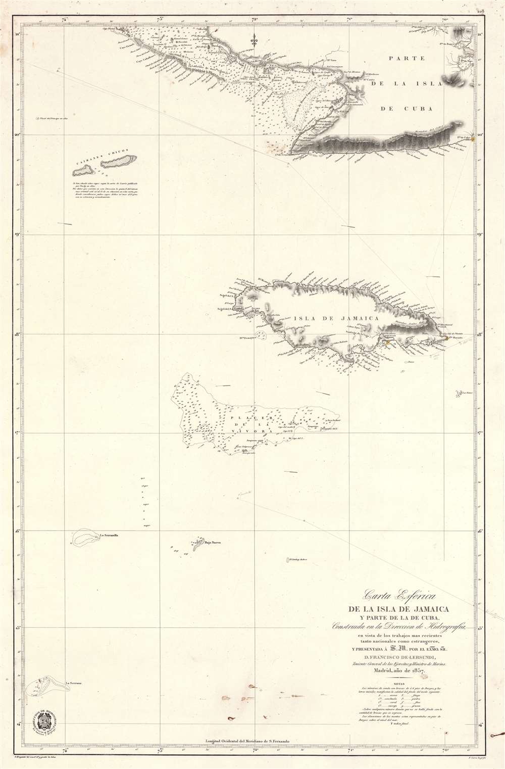
Carta Esférica de la Isla de Jamaica y Parte de la de Cuba.
1857 (dated) 37.5 x 24.75 in (95.25 x 62.865 cm) 1 : 920000
1857 (dated) 37.5 x 24.75 in (95.25 x 62.865 cm) 1 : 920000
Description
A scarce 1857 Dirección de Hidrografía nautical chart or maritime map of Jamaica, the Little Cayman Islands, and Southern Cuba. Centered on Pendro Bank (Vibora), the map extends as far north as Nipe Bay on Cuba's north coast, and as far west as Little Cayman. The seas to the south are largely empty, but the Serrana Bank atoll in the western Caribbean is noted.
Manuscript Voyage
The track of an unknown Spanish voyage that took place in April 1867 is traced. The voyage stops at Kingston, Jamaica, before proceeding westward along the south coast of Cuba. Another voyage - or perhaps the same voyage in February (either before or after) sails northwest towards the Placer de la Vivora, where it mysteriously terminates.Viper Bank
The map is centered on the Pedro Bank, named here Placer de la Vibora (Viper Bank), as Spanish mariners considered the layout similar to an undulating serpent. The emphasis on Pedro Bank here is no mistake. This was a busy shipping channel - note the voyage described hereon in manuscript approaches the bank, then seems to stop - what happened? Archeologists estimate that there are over 300 shipwrecks on the bank. Today it is popular with fishermen, snorkelers, and Scuba enthusiasts.Publication History and Census
This map was published by the Spanish Dirección de Hidrografía in 1857. It was engraved by Francisco Bregante y Orbay and Pascual Serra y Mas. This chart is scarce. We note multiple entries in the OCLC, but none actually connected to a physical library - we believe most to reference the same digital file, apparently based upon an example from the American Geographical Society Library, now located at the University of Wisconsin-Milwaukee. Scarce on the market.CartographerS
The Direccion Hidrografía (1787 - 1927), also known as the Deposito Hydrografico and the Direction de Hidrografía, was the Spanish equivalent of the British Admiralty or the U.S. Coast Survey. This organization, founded in 1787, was commissioned to collect and produce accurate nautical charts of all waters frequented by Spanish vessels. In essence, it replaced the Casa de la Contratación de las Indias (House of Trade of the Indies), which closed its doors in 1790. Like most such organizations, the Direccion Hidrografía marked a new age in cartography. Rather than simply collect charts created by navigators, explorers, and merchants, the Direccion Hidrografía worked closely with naval and military personnel to mount cartographic and hydrographic expeditions in pursuit of the most accurate hydrographical, astronomical, and geodetic measurements. The Direccion Hidrografía created a massive library of nautical charts that, though not nearly as common as similar nautical charts by the U.S. Coast Survey and British Admiralty, are highly desirable for the beauty of their manufacture as well as their accuracy and detail. The office was originally located on Calle Ballesta, but relocated to 36 Alcala, both in Madrid. After 1908 the Dirección was subsumed into other governmental agencies. In 1927 the Direccion was absorbed into the Institute and Observatory of San Fernando, located in Cadiz. The library of original maps, charts, and journals was transferred to the Naval Museum of Madrid - where it resides to this day. More by this mapmaker...
Francisco Bregante y Orbay (fl. 1840 - 1867) was a Spanish engraver and draftsman active with the Dirección Hidrografía in the middle part of the 19th century. Bregante y Orbay specialized in lettering and text. A relative, Salvador Bregante y Orbay, also worked for the Dirección Hidrografía in a related capacity. Learn More...
Pascual Serra y Mas (fl. c. 1853 - 1883) was a Spanish line and letter engraver engaged with the Direccion de Hidrografia or Deposito Hidrografico in the second half of the 19th century. Learn More...
Condition
Very good. Minor soiling at bottom center and near title. Pencil annotations relating to an 1867 voyage.