1773 Mount and Page Map of Jamaica
Jamaica-mountpage-1773$750.00

Title
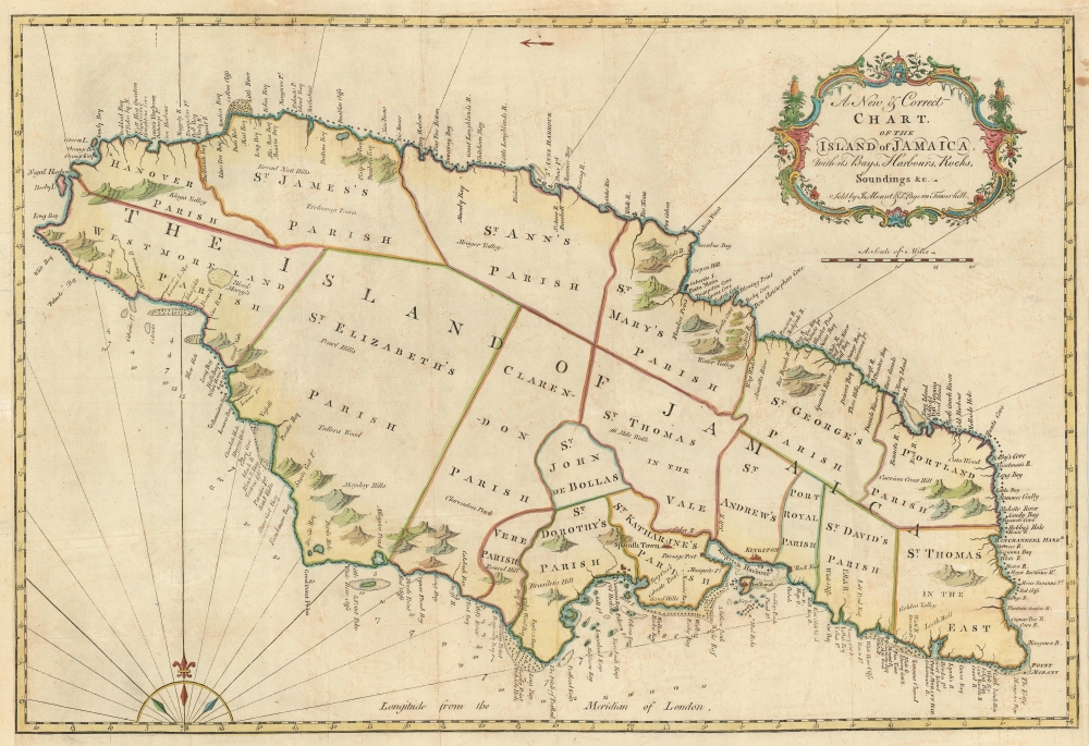
A New and Correct Chart of the Island of Jamaica wih its Bays, Harbors, Rocks, Soundings etc. Sold by J. Mount and T. Page on Tower Hill.
1773 (undated) 17.75 x 26.75 in (45.085 x 67.945 cm) 1 : 323104
1773 (undated) 17.75 x 26.75 in (45.085 x 67.945 cm) 1 : 323104
Description
This detailed, large 1773 Mount and Page map of Jamaica was, at the time of its publication, one of the most accurate maps of the island available to the English navigator - The English Pilot being the first entirely English sea atlas to focus on American waters.
A Closer Look
The map, properly speaking, is more of a chart - showing its best detail in coastal features, such as anchorages. Numerous depth soundings appear, and data for elevations just inland is provided. Port Royal, Kingston, Spanish Town, Careening Caye, and Rock Fort are all shown, with the rest of the island bereft of settlement, apart from Trelawny town (noted in the location of the parish of that name, which does not appear.) The interior of the island - which would be the site of both the island's sugar industry and its long history of slave uprisings, appears vacant here. Whether this is due to a lack of data or the primary role of this map as a coastal chart is unclear.Publication History and Census
This map appeared in Mount and Page's navigational atlas, The English Pilot. It was included in the fourth volume, which was dedicated to the navigation of the West Indies. Many editions of the atlas were produced, and there is little to distinguish one edition from another as the publishers were less than diligent in updating their work.Cartographer
Mount and Page (fl. 1701 - 1760) was a London based firm of religious and maritime publishers that flourished in the 18th century. With the publication of the 1732 English Pilot, the Mount and Page name became well-known worldwide as an imprint of nautical charts. The firm was founded at Tower Hill, London, in 1701 by Richard Mount (1654 - 1722) and his apprentice Thomas Page (1780 - March 15, 1733). Mount had previously been in partnership with his father-in-law William Fisher (1631 - 1691) and inherited the business on the latter's death. Page completed his apprenticeship in 1716. Now fully partnered, Mount and Page subsequently acquired the map plates several defunct British nautical chart publishers, including Greenville Collins, Jeremiah Seller, Charles Price, and John and Samuel Thornton - thus nearly monopolizing the British nautical chart business. The firm consequently received several lucrative government contracts and thereby flourished throughout the 18th century, making the fortunes of both families. Successive generations of Mounts and Pages worked in the business, and the families intermarried. Its staple titles were The English Pilot and Navigatio Britannica by John Barrow. By the 1760s, Richard Mount's grandson John Mount (1725 - 1786) was able to retire to Berkshire where he built the stately mansion, Wasing Place. John's son William (1753 - 1815) was the last to work in the map business, and later generations went into politics. More by this mapmaker...
Source
The English Pilot. Fourth Book, (London: Mount and Page) c. 1773.
Condition
Very good. Centerfold reinforced, few marginal mends not affecting image.
References
Rumsey 12434.000. OCLC 951681407. Sellers and Van Ee #1922; Shirley (BL Atlases) M.MandP-5h #17. Phillips 3563 [20].