This item has been sold, but you can get on the Waitlist to be notified if another example becomes available, or purchase a digital scan.
1659 Blaeu Map of Jan Mayen Island
JanMayenIsland-blaeu-1659$475.00

Title
Insula quae à Joanne Mayen nomen sortita est.
1659 (undated) 17.25 x 21.5 in (43.815 x 54.61 cm) 1 : 104095
1659 (undated) 17.25 x 21.5 in (43.815 x 54.61 cm) 1 : 104095
Description
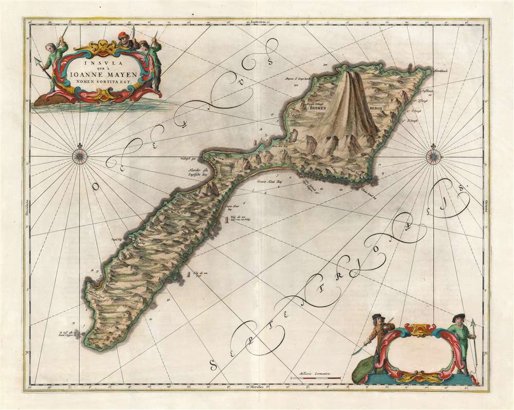
This is a beautiful and rare original-color Dutch Golden Age 1659 Blaeu map of Jan Mayen, a volcanic island in the Arctic, and a possession of Norway. Having no permanent population, the island was primarily a whaling post, as witness the hapless cetaceans and harpoon-brandishing sailors in the superbly engraved cartouches.
A Closer Look
The island's mountainous, glaciered terrain is evocatively depicted, with the northeast end dominated by the Beerenberg volcano. The rocky, treacherous shore - which claimed ships as recently as the Second World War, when the island was contested as a radio listening post - is clearly depicted, with special attention to rocky landmarks such as Klip als een Seyl van een Schip (Rock like the sail of a ship).Jan Mayan Island
Jan Mayen Island is, in the modern era, exploited solely for gravel. Its surrounding waters are important fishing grounds, worked both by Norway and Denmark. While there is reasonable speculation that Jan Mayen had been visited by the Irish of the 9th century, or the Vikings, there is no archaeological evidence to support it, and no record of such landings has survived. Rivalry between the Dutch and the English over the Arctic whaling grounds offered competing claims on the part of both the seafaring nations, as early as 1607. The first definite landfalls of Jan Mayen occurred in 1614. One of these, on behalf of the Noordsche Compagnie, was led by captain Jan Jacobszoon May van Shellinkhout; he named the island after the ship's cartographer (Mr. Joris Eyland, after Joris Carolus). The following year, English whaler Robert Fotherby landed on the island, and being under the impression he was the first to discover the place, named it 'Sir Thomas Smith's Island.' Willem Blaeu included the island on his map of Europe, and there named it 'Jan Mayen' after Jan Jacobszoon May, emphasizing the Dutch discovery. The elder Blaeu produced the first detailed chart of the island in his 1623 Zeespiegel, which entrenched the name further.The Whaling Post
Beginning in 1614, the Dutch Noordsche Compagnie claimed a monopoly on Arctic whaling. Between 1615 and 1638, Jan Mayen was used as a base for those operations. The map includes buildings along the northwest coast of the island, where the Dutch maintained stations, visible at South and North Bay. There were forts constructed in 1628 to defend the stations, one of which appears as 'Brielsche Toorn' north of the settlement. A team of seven Dutch who stayed the winter of 1633 to defend the island died either of scurvy or trichinosis (from eating raw polar bear meat). They were memorialized with a cross overlooking Sjuhollendarbukta (Seven Hollander Bay.) The cross appears on the map.The Competition's Map
Joan Blaeu's map does not reproduce his father's work. Rather, it follows the model of competitor Jan Jansson's 1650 map of the island. This was produced after the boom in Arctic whaling, which diminished around 1640 at which point the population of bowhead whales had been hunted to near extinction. Jansson's source is not known, but the improvement of detail at the coast over Blaeu's 1623 chart suggests that he had access to the charts of the Noordsche Compagnie.Publication History and Census
This map is rare, having appeared in only four editions of the Blaeu Atlas Maior, and only in the 1659 Spanish edition of the Nuevo atlas o Teatro del mundo (with which this example conforms typographically.) Three examples of the complete Nuevo atlas o Teatro del mundo are cataloged in OCLC. There is only one example of this separate map cataloged in OCLC, misidentified by Durham University Palace Green Library as the Jansson.CartographerS
Joan (Johannes) Blaeu (September 23, 1596 - December 21, 1673) was a Dutch cartographer active in the 17th century. Joan was the son of Willem Janszoon Blaeu, founder of the Blaeu firm. Like his father Willem, Johannes was born in Alkmaar, North Holland. He studied Law, attaining a doctorate, before moving to Amsterdam to join the family mapmaking business. In 1633, Willem arranged for Johannes to take over Hessel Gerritsz's position as the official chartmaker of the Dutch East India Company, although little is known of his work for that organization, which was by contract and oath secretive. What is known is his work supplying the fabulously wealthy VOC with charts was exceedingly profitable. Where other cartographers often fell into financial ruin, the Blaeu firm thrived. It was most likely those profits that allowed the firm to publish the Theatrum Orbis Terrarum, sive, Atlas Novus, their most significant and best-known publication. When Willem Blaeu died in 1638, Johannes, along with his brother Cornelius Blaeu (1616 - 1648) took over the management of the Blaeu firm. In 1662, Joan and Cornelius produced a vastly expanded and updated work, the Atlas Maior, whose handful of editions ranged from 9 to an astonishing 12 volumes. Under the brothers' capable management, the firm continued to prosper until the 1672 Great Amsterdam Fire destroyed their offices and most of their printing plates. Johannes Blaeu, witnessing the destruction of his life's work, died in despondence the following year. He is buried in the Dutch Reformist cemetery of Westerkerk. Johannes Blaeu was survived by his son, also Johannes but commonly called Joan II, who inherited the family's VOC contract, for whom he compiled maps until 1712. More by this mapmaker...
Jan Jansson or Johannes Janssonius (1588 - 1664) was born in Arnhem, Holland. He was the son of a printer and bookseller and in 1612 married into the cartographically prominent Hondius family. Following his marriage he moved to Amsterdam where he worked as a book publisher. It was not until 1616 that Jansson produced his first maps, most of which were heavily influenced by Blaeu. In the mid 1630s Jansson partnered with his brother-in-law, Henricus Hondius, to produce his important work, the eleven volume Atlas Major. About this time, Jansson's name also begins to appear on Hondius reissues of notable Mercator/Hondius atlases. Jansson's last major work was his issue of the 1646 full edition of Jansson's English Country Maps. Following Jansson's death in 1664 the company was taken over by Jansson's brother-in-law Johannes Waesberger. Waesberger adopted the name of Jansonius and published a new Atlas Contractus in two volumes with Jansson's other son-in-law Elizée Weyerstraet with the imprint 'Joannis Janssonii haeredes' in 1666. These maps also refer to the firm of Janssonius-Waesbergius. The name of Moses Pitt, an English map publisher, was added to the Janssonius-Waesbergius imprint for maps printed in England for use in Pitt's English Atlas. Learn More...
Source
Blaeu, J., Nuevo Atlas, (Amsterdam: Blaeu) 1659.
The classic Dutch atlas, whose publication ushered in the Dutch golden age of cartography. Willem Jansz Blaeu had been, since 1604, producing engraved maps for sale; these were separate issues (and all consequently extremely rare) until the publishing of Blaeu's Appendix in 1630 and 1631, which also included a number of maps purchased from the widow of Jodocus Hondius, (for example his famous iteration of John Smith's map of Virginia.) In 1634, he announced his intention to produce a new world atlas in two volumes, entitled Theatrum Orbis Terrarum, sive Atlas Novus (Théâtre du Monde ou Nouvel Atlas) (in an effort to invoke the successful work of the same title produced by Ortelius the previous century, while reinforcing the notion of it being a new work.) This work was published first in German in 1634, followed by Latin, Dutch and French editions in 1635. Blaeu's maps have always been noted for the quality of their paper, engraving and fine coloring, and this was the intent from the very start. The 1634 announcement of the upcoming work described it: 'All editions on very fine paper, completely renewed with newly engraved copperplates and new, comprehensive descriptions.' (van der Krogt, p,43) Many of the most beautiful and desirable maps available to the modern collector were printed and bound in Blaeu's atlases. Willem's son, Joan, would go on to add further volumes to the Atlas Novus, concurrently printing new editions of the first two volumes with additional maps, in effect making these new editions an entirely new book. Under Joan there would be nine Latin editions, twelve French, at least seven Dutch, and two German. This exceedingly successful work would be the mainstay of the Blaeu firm until 1661, at which point the work was supplanted by Joan Blaeu's masterwork Atlas Maior in 1662.
Condition
Good. Centerfold reinforced with a mend in water area, not impacting printed image. Superb original color.
References
OCLC 1015527234 (misidentified as Jansson). Ginsberg, W. B. Maps and Mapping of Norway 1602-1855, Bla 7. Van der Krogt, P. C. J., Koeman's Atlantes Neerlandici, V. 2, 1265:2:641.