
This item below is out of stock, but another example (left) is available. To view the available item, click "Details."
Details
1815 Thomson Map of Korea and Japan
1815 (dated) $750.00
1815 Thomson Map of Japan and Korea
JapanCorea-thomson-1815$225.00

Title
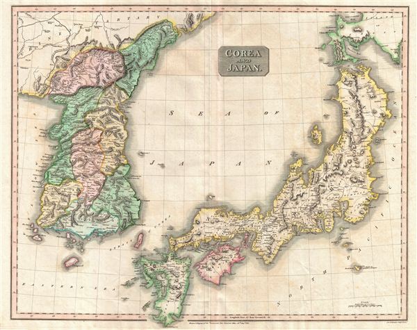
Corea and Japan.
1815 (dated) 20 x 25 in (50.8 x 63.5 cm)
1815 (dated) 20 x 25 in (50.8 x 63.5 cm)
Description
This fascinating hand colored 1814 map depicts Korea and Japan. Both Korea and Japan are divided according to their constituent provinces with Hokkaido, identified as Jesso (Yesso), partially off the map. The island of Hachijo (incorrectly identified here as Fatsisio), just south of Edo Bay, is identified as a 'Place of Exile for the Grandees of Japan.' Though the Izu Islands were in fact used as convict settlements in the 18th century, Hachijo Island was not particular in that respect, nor was the social status of its criminals. A wall of wooden spikes dividing Chinese Tartary (today's Manchuria) from Korea is also noted. The sea between Japan and Korea, whose name, either the 'Sea of Korea' or the 'Sea of Japan,' is currently a matter of historical and political dispute between the two countries, is here identified in favor of Japan.
The whole is beautifully engraved in the minimalist English style pioneered in the early part of the 19th century. Thomson maps are known for their stunning color, awe inspiring size, and magnificent detail. Thomson's work, including this map, represents some of the finest cartographic art of the 19th century. Relief is shown by hachure with towns, cities, and major topographical features identified. Engraved in 1814 by J. and G. Menzies and issued as Plate no. 34 for Edinburgh cartographer John Thomson's 1817 issue of the New General Atlas.
The whole is beautifully engraved in the minimalist English style pioneered in the early part of the 19th century. Thomson maps are known for their stunning color, awe inspiring size, and magnificent detail. Thomson's work, including this map, represents some of the finest cartographic art of the 19th century. Relief is shown by hachure with towns, cities, and major topographical features identified. Engraved in 1814 by J. and G. Menzies and issued as Plate no. 34 for Edinburgh cartographer John Thomson's 1817 issue of the New General Atlas.
Cartographer
John Thomson (1777 - c. 1841) was a Scottish cartographer, publisher, and bookbinder active in Edinburgh during the early part of the 19th century. Thomson apprenticed under Edinburgh bookbinder Robert Alison. After his apprenticeship, he briefly went into business with Abraham Thomson. Later, the two parted ways, John Thomson segueing into maps and Abraham Thomson taking over the bookbinding portion of the business. Thomson is generally one of the leading publishers in the Edinburgh school of cartography, which flourished from roughly 1800 to 1830. Thomson and his contemporaries (Pinkerton and Cary) redefined European cartography by abandoning typical 18th-century decorative elements such as elaborate title cartouches and fantastic beasts in favor of detail and accuracy. Thomson's principle works include Thomson's New General Atlas, published from 1814 to 1821, the New Classical and Historical Atlas of 1829, and his 1830 Atlas of Scotland. The Atlas of Scotland, a work of groundbreaking detail and dedication, would eventually bankrupt the Thomson firm in 1830, at which time their plates were sequestered by the court. The firm partially recovered in the subsequent year, allowing Thomson to reclaim his printing plates in 1831, but filed again for bankruptcy in 1835, at which time most of his printing plates were sold to A. K. Johnston and Company. There is some suggestion that he continued to work as a bookbinder until 1841. Today, Thomson maps are becoming increasingly rare as they are highly admired for their impressive size, vivid hand coloration, and superb detail. More by this mapmaker...
Source
Thomson, J. A New General Atlas, (Edinburgh) 1814.
Condition
Very good condition. Original centerfold. Some offsetting. Blank on verso. Original platemark visible.
References
Rumsey 1007.041. Phillips (Atlases) 731. Newberry Library: Ayer 135 T4 1817.