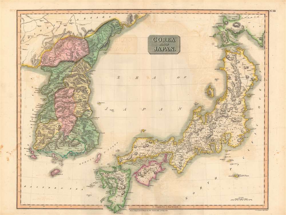
1815 Thomson Map of Korea and Japan
JapanCorea-thomson-1815-2$750.00

Title
Corea and Japan.
1815 (dated) 8 x 12.25 in (20.32 x 31.115 cm) 1 : 2800000
1815 (dated) 8 x 12.25 in (20.32 x 31.115 cm) 1 : 2800000
Description
This fascinating hand colored 1815 map depicts Joseon Korea and Tokugawa Japan, both of which would be drastically changed by the end of the century. The level of detail attempted here is impressive given the great difficulties faced by foreigners trying to travel to either country at the time.
The wall of wooden spikes referred to in Chinese Tartary (Manchuria) is the Willow Palisade (柳條邊). The Manchu rulers of the Qing Dynasty had built the palisades as an attempt to restrict migration from the Han Chinese heartland into their ancestral homeland, an effort which ultimately failed.
As both Korea and Japan tightly restricted foreign interaction at this time, it is curious that Thomson was able to map the interiors of the countries in so much detail. For Japan, his information likely came indirectly from Dutch and Chinese traders who were permitted to reside on offshore islands at Nagasaki. For Korea, his source may have been Catholic missionaries who occasionally snuck into Korea (and were typically executed after being discovered), as well as Catholic missionaries who resided at the Qing Court in Beijing, interacted with the Korean diplomatic and trade mission there, and wrote back to Europe with second-hand knowledge of Korea. The fact that the names of places in Korea are rendered in the Chinese style, as opposed to the Korean pronunciation of their Chinese characters, lends credence to the latter interpretation.
While Japan allowed limited trade with the Dutch at Nagasaki, Korea's interaction with the West was mostly indirect, via China, to the extent that it came to be called the 'hermit kingdom' among Westerners, making Thomson's mapping of the interior even more impressive. By the mid-19th century, both countries (and China) faced direct military attacks at the hands of Western powers and by the early 20th century the political system, culture, and society of all three countries had changed fundamentally as a result. Moreover, Japan set about controlling and then colonizing Korea over several decades at the turn of the 20th century, displacing China as the predominant power in East Asia.
Relief is shown by hachures with towns, cities, and major topographical features identified. The whole is beautifully engraved in the minimalist English style pioneered in the early part of the 19th century. Thomson maps are known for their stunning color and magnificent detail. His work, including this map, represents some of the finest cartographic art of the 19th century.
A Closer Look
Both Korea and Japan are divided according to their constituent provinces with Hokkaido, identified as Jesso (Yesso), partially off the map. The island of Hachijo (incorrectly identified here as Fatsisio), just south of Edo Bay, is identified as a 'Place of Exile for the Grandees of Japan.' Though the Izu Islands were in fact used as convict settlements in the 18th century, Hachijo Island was not particular in that respect, nor was the social status of its criminals.The wall of wooden spikes referred to in Chinese Tartary (Manchuria) is the Willow Palisade (柳條邊). The Manchu rulers of the Qing Dynasty had built the palisades as an attempt to restrict migration from the Han Chinese heartland into their ancestral homeland, an effort which ultimately failed.
As both Korea and Japan tightly restricted foreign interaction at this time, it is curious that Thomson was able to map the interiors of the countries in so much detail. For Japan, his information likely came indirectly from Dutch and Chinese traders who were permitted to reside on offshore islands at Nagasaki. For Korea, his source may have been Catholic missionaries who occasionally snuck into Korea (and were typically executed after being discovered), as well as Catholic missionaries who resided at the Qing Court in Beijing, interacted with the Korean diplomatic and trade mission there, and wrote back to Europe with second-hand knowledge of Korea. The fact that the names of places in Korea are rendered in the Chinese style, as opposed to the Korean pronunciation of their Chinese characters, lends credence to the latter interpretation.
Domestic and Foreign Challenges
When this map was made in the early 19th century, both Joseon Korea and Tokugawa Japan were facing foreign and domestic crises. Both societies reached their ecological and demographic limits and faced regular famines and natural disasters. Simultaneously, improvements in navigation and naval technology allowed Western vessels to travel more frequently and precisely to their shores. Both countries had strict policies to limit foreign influence, and both were especially wary of Christianity, which they saw as subversive.While Japan allowed limited trade with the Dutch at Nagasaki, Korea's interaction with the West was mostly indirect, via China, to the extent that it came to be called the 'hermit kingdom' among Westerners, making Thomson's mapping of the interior even more impressive. By the mid-19th century, both countries (and China) faced direct military attacks at the hands of Western powers and by the early 20th century the political system, culture, and society of all three countries had changed fundamentally as a result. Moreover, Japan set about controlling and then colonizing Korea over several decades at the turn of the 20th century, displacing China as the predominant power in East Asia.
Relief is shown by hachures with towns, cities, and major topographical features identified. The whole is beautifully engraved in the minimalist English style pioneered in the early part of the 19th century. Thomson maps are known for their stunning color and magnificent detail. His work, including this map, represents some of the finest cartographic art of the 19th century.
Publication History
This map is a steel plate engraving prepared by John Thomson and engraved by 'J. and G. Menzies,' almost certainly the Edinburgh-based engraver John Menzies. It was issued as Plate no. 38 of the August 1815 edition of Thomson's New General Atlas.CartographerS
John Thomson (1777 - c. 1841) was a Scottish cartographer, publisher, and bookbinder active in Edinburgh during the early part of the 19th century. Thomson apprenticed under Edinburgh bookbinder Robert Alison. After his apprenticeship, he briefly went into business with Abraham Thomson. Later, the two parted ways, John Thomson segueing into maps and Abraham Thomson taking over the bookbinding portion of the business. Thomson is generally one of the leading publishers in the Edinburgh school of cartography, which flourished from roughly 1800 to 1830. Thomson and his contemporaries (Pinkerton and Cary) redefined European cartography by abandoning typical 18th-century decorative elements such as elaborate title cartouches and fantastic beasts in favor of detail and accuracy. Thomson's principle works include Thomson's New General Atlas, published from 1814 to 1821, the New Classical and Historical Atlas of 1829, and his 1830 Atlas of Scotland. The Atlas of Scotland, a work of groundbreaking detail and dedication, would eventually bankrupt the Thomson firm in 1830, at which time their plates were sequestered by the court. The firm partially recovered in the subsequent year, allowing Thomson to reclaim his printing plates in 1831, but filed again for bankruptcy in 1835, at which time most of his printing plates were sold to A. K. Johnston and Company. There is some suggestion that he continued to work as a bookbinder until 1841. Today, Thomson maps are becoming increasingly rare as they are highly admired for their impressive size, vivid hand coloration, and superb detail. More by this mapmaker...
John Menzies (October 27, 1772 - October 16, 1857) was a Scottish engraver active in Edinburgh during the late 18th and early 19th centuries. Menzies mastered engraving as an apprentice to James Rymer. In 1811, he partnered with his younger brother, George Menzies, to found the engraving firm of J. and G. Menzies, which was active until about 1831. Later his son, also named John, joined the firm and they engraved jointly under the imprint of J. Menzies and Son. At its height, the Menzies firm employed three men and three apprentices. Menzies engraved maps for Thomas Brown and John Thomson, among others. After his death, his son, John Menzies II (1819 – 1891), continued the family business until about 1891. Learn More...
Source
Thomson, J. A New General Atlas, (Edinburgh) 1815.
Condition
Very good. Some transference.
References
Rumsey 1007.041, OCLC 961940949. Phillips (Atlases) 731. Newberry Library: Ayer 135 T4 1817.