This item has been sold, but you can get on the Waitlist to be notified if another example becomes available, or purchase a digital scan.
1921 Bird's-Eye View Railroad Map of the New Japan Empire
JapanEmpire-asahishimbun-1921$625.00

Title
Bird's eye view of the New Japan. / 新日本鳥瞰圖
1921 (dated) 29.5 x 41.25 in (74.93 x 104.775 cm)
1921 (dated) 29.5 x 41.25 in (74.93 x 104.775 cm)
Description
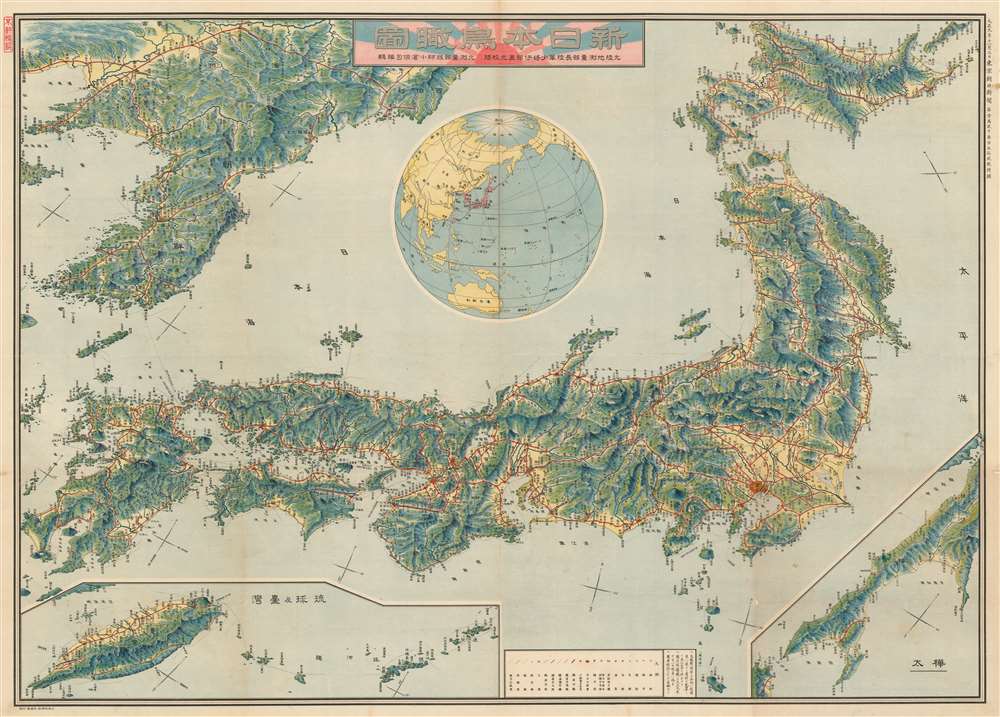
This is a rare and stunningly produced Taisho 10 or 1921 map of the Japanese Empire, including Taiwan and Korea, issued by the daily Tokyo Asahi Shimbun. The map uses a bird's-eye view model to illustrate the Japanese islands as well as Japanese imperial claims in Korea, Taiwan, The Ryukyu's, and Karafuto (Sakhalin). A globe appears a center, situating Japan in a global context. Red lines illustrate the empire-wide railroad network, with stops and connections identified throughout.
The New Japan
The map is entitled 'Bird's Eye View of the New Japan,' the emphasis being on 'New.' From 1900 to 1920 Japan undergone a period of major expansion and modernization. Days after this map was issued, the governors of Japan would sit down as equals with the major European and American powers at the Washington Naval Conference - by doing so Japan established itself as a major world power - the first Asian nation to do so. While superficially illustrating the Japanese railroad network, this communicates a greater message. It illustrates the full extent of the expanding Japanese Empire. A globe at center presents Japan at the center of a world stage, with imperial and maritime connections that extend throughout Asia, to Australia, Europe, and the Americas.Publication History and Census
This map was published by the Tokyo Asahi Shimbun as a supplement to issue no. 12352 on November 3, 1921. The map was prepared by Naomitsu Ibe ( 直光伊部), retired general and had of the land survey department. Cartographically it is based upon work completed by Kenji Ogura.CartographerS
The Asahi Shimbun (朝日新聞; January 25, 1879 – Present), translated Morning Sun Newspaper, is one of Japan's oldest and most venerable daily newspapers. The Asahi Shimbun began publication in Osaka on January 25, 1879 as a small-print, four-page illustrated paper. The paper was founded by Kimura Noboru (company president), Murayama Ryōhei (owner), and Tsuda Tei (managing editor). In 1888 the newspaper expanded with a branch in Tokyo and began issuing the Tokyo Asahi Shimbun. The the Osaka and Tokyo papers formally merged under a single imprint in 1940. Almost from its inception the newspaper was known for its liberal views. The Asahi Shimbun continues to publish from Osaka today. More by this mapmaker...
Naomitsu Ibe (伊部直光, April 2, 1867 - July 5, 1932) was a Japanese army officer and head of the Japanese Land Survey Department in the early 20th century. Naomitsu was born in Musashi, today part of Tokyo. He studied at the Military Academy, graduating in July of 1887 with a specialization in military engineering. He rose through the ranks becoming a Major General in August of 1913. After retiring from the military in 1914, he became the state director of Land Surveying and as such his name is attached to many maps. Learn More...
Condition
Very good. Minor repair at fold intersections.
References
Rumsey 11356.000