
This item below is out of stock, but another example (left) is available. To view the available item, click "Details."
Details
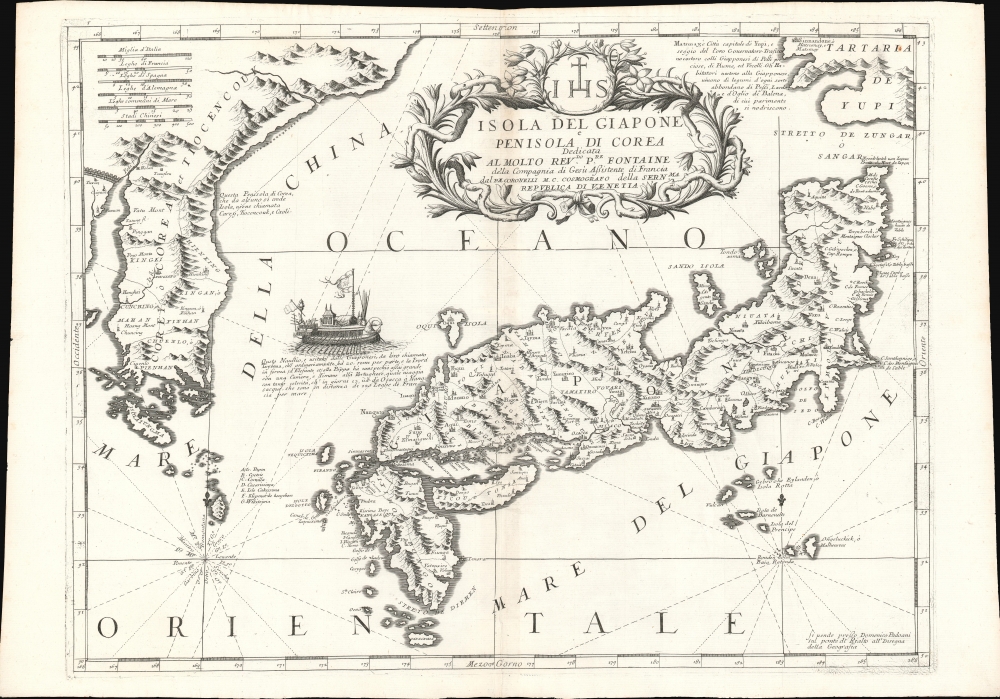
1692 Coronelli Map of Japan and Korea
$2,500.00
1692 Coronelli Map of Japan and Korea
JapanKorea-coronelli-1692$1,000.00

Title
Isola Del Giapone e Penisola Di Corea.
1692 (undated) 18 x 24.25 in (45.72 x 61.595 cm) 1 : 3400000
1692 (undated) 18 x 24.25 in (45.72 x 61.595 cm) 1 : 3400000
Description
This is the 1692 Vincenzo Coronelli map of Japan and Korea. With bold engraving typical of Coronelli, this is among the most visually distinctive maps of the Japanese Islands produced in the 17th century. Moreover, it introduces unique new cartographic knowledge derived from the most up-to-date Jesuit sources.
Jesuit Sources
Coronelli had access to Dutch sea charts, which he supplemented with material from French Jesuits, with whom he maintained strong connections - note the Jesuit sigil in the dedicatory cartouche. Jesuits were the only Europeans with access to firsthand knowledge of Japan, so any mapmaker who wished to produce a credible map had to acknowledge their work. The coastlines are drawn based on the 1655 Martini map. A magnificent rowing galley - ascribed to the Japanese, but, in reality, Korean - plies the sea between Japan and the mainland.Publication History and Census
This map appeared in Coronelli’s 1692 Corso Geografico Universale. Although also included in his 1697 Atlante Veneto, the lack of verso text on this example indicates it is from the earlier work. This edition of the map is cataloged separately only by Harvard, the Osher Map Library, and the Biblioteca Nacional de Espana. The Corso Geografico Universale is listed only in 7 institutions in OCLC, with the Atlante Veneto being better represented.Cartographer
Vincenzo Maria Coronelli (August 16, 1650 - December 9, 1718) was an important 17th-century cartographer and globe maker based in Venice. Coronelli was born the fifth child of a Venetian tailor. Unlikely to inherit his father's business, he instead apprenticed in Ravenna to a woodcut artist. Around 1663, Coronelli joined the Franciscan Order and, in 1671, entered the Venetian convent of Saint Maria Gloriosa dei Frari. Coronelli excelled in the fields of cosmography, mathematics, and geography. Although his works include the phenomenal Atlante Veneto and Corso Geografico, Coronelli is best known for his globes. In 1678, Coronelli was commissioned to make his first major globes by Ranuccio II Farnese, Duke of Parma. Each superbly engraved globe was five feet in diameter. Louis IV of France, having heard of the magnificent Parma globes, invited Coronelli to Paris, where from 1681-83 he constructed an even more impressive pair of globes measuring over 12 feet in diameter and weighing 2 tons each. The globes earned him the patronage of Louis XIV and privileged access to French cartographic information from Jesuit sources in the New World, particularly Louisiana. Coronelli returned to Venice and continued to publish globes, maps, and atlases, which were admired all over Europe for their beauty, accuracy, and detail. He had a particular fascination for the Great Lakes region, and his early maps of this area were unsurpassed in accuracy for nearly 100 years after their initial publication. He is also well known for his groundbreaking publication of the first accurate map depicting the sources of the Blue Nile. At the height of his career, Coronelli founded the world's first geographical society, the Accademia Cosmografica degli Argonauti, and was awarded the official title Cosmographer of the Republic of Venice. In 1699, in recognition of his extraordinary accomplishment and scholarship, Coronelli was also appointed Father General of the Franciscan Order. The great cartographer and globe maker died in Venice at the age of 68. His extraordinary globes can be seen today at the Bibliothèque Nationale François Mitterrand in Paris, Biblioteca Marciana in Venice, the National Library of Austria, the Globe Museum in Vienna, the Library of Stift Melk, the Special Collections Library of Texas Tech University, as well as lesser works in Trier, Prague, London, and Washington D.C. Coronelli's work is notable for its distinctive style, which is characterized by the high-quality white paper, dark intense impressions, detailed renderings of topographical features in profile, and numerous cartographic innovations. More by this mapmaker...
Source
Coronelli, V., Corso Geografico Universale, (Venice) 1692.
The Corso Geografico Universale was a Venetian cosmographic atlas issued by the Jesuit Minorite friar, geographer, and globe maker Vincenzo Maria Coronelli. The Corso Geografico is generally dated to 1692 and is considered a follow-up to the Atlante Veneto. There is no confirmed collation of the atlas, as all editions were assembled ad-hoc. Also maps for the atlas were also sold separately, and to subscribers the rate of six cards a month for two years. The maps of the Corso Geografico are generally unique works of great historical value. They are also masterpieces of craftsmanship, engraved between 1688 and 1692 in the well-equipped cartographic workshop of the Saint Maria Gloriosa dei Frari Convent. Editions of the Corso Geografico can roughly be broken up as 68 maps 1689-92; 173 maps, 1692; 260 maps, 1694-97).
Condition
Very good. Some filled wormholes with virtually no loss to printed image. Toned at centerfold.
References
OCLC 667618211. Rumsey 11391.130 (1697 Atlante Veneto). Cortazzi, Isles of Gold, p. 48, pl. 75. Potter, Country Life Book of Antique Maps, pp. 126-27.