This item has been sold, but you can get on the Waitlist to be notified if another example becomes available, or purchase a digital scan.
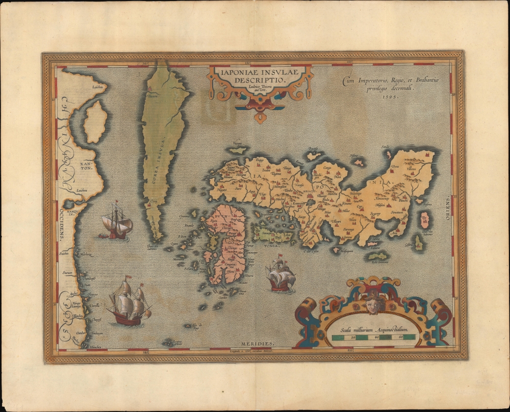
1595 / 1609 Ortelius - Teixiera Map of Japan and Korea
JapanKorea-ortelius-1595$1,250.00

Title
Japoniae Insula Descriptio.
1595 (dated) 13.75 x 19 in (34.925 x 48.26 cm) 1 : 4500000
1595 (dated) 13.75 x 19 in (34.925 x 48.26 cm) 1 : 4500000
Description
This is the 1606 second state of Ortelius' map of Japan and Korea, considered the earliest detailed printed map of Japan and Korea. This map is of fundamental importance: according to map historian Lutz Walter, 'A new epoch in Western cartography of Japan begins with the inclusion of this in the Theatrum … Honshu, Kyushu, and Shikoku are depicted with approximately correct proportions for the first time.' (Walter, L. Japan: A Cartographic Vision.)
The placenames of Teixeira's map are derived from a Japanese source - almost certainly a Gyōgi-type map - but this map is distinctly the product of European geographical methodology. Its presentation of Honshu, Kyushu, and Shikoku is more accurate than any earlier Western map as well as any Japanese Gyōgi-type map.
Ortelius' earlier maps of the East Indies, Asia, China, and the world incorporated different depictions of Japan derived from Portuguese sources - notably charts of Bartolomeu Velho (c. 1560), and Fernão Vaz Dourado (1568). Teixeira's map was the first to provide Ortelius sufficient detail for a dedicated specific map of Japan, which served as the model for all European maps of Japan until 1655 Martino Martini's map. Teixiera's initial source is unknown, but Donald Lach (1965) suggests geographer Inácio Moreira, who visited Japan from 1584 to 1585.
It is fair to note that while Ortelius called Korea an island on the map, he did not depict it as one: the northern end runs off the top of the map, and its shoreline is not complete - leaving considerable ambiguity. Hondius, in his 1606 iteration of the map, completed the coastline while adding more descriptive text. In 1626, John Speed definitively portrayed Korea as an island.
The First Geographical Map of Japan
The source map was sent to Ortelius on February 20, 1592, by Luís Teixeira, court cartographer to the King of Spain. Teixeira's Portuguese Jesuit sources were informed by firsthand exploration of Japan during a period of extensive proselytizing. The map's placenames incorporate information from Japanese sources, but the cartography does not derive from contemporaneous Japanese maps. Japanese maps of Japan contemporaneous to Teixeira's map significantly differ from the present work. Credited in form to the 7th-8th century Buddhist Gyōgi Bosatsu, these maps presented the Japanese provinces in relation to each other and the capital. They did not attempt to accurately represent terrestrial geography (mountains, rivers, or islands) or cities. The Jesuit Alessandro Valignano, who visited Japan three times between 1579 and 1603, observed that while the Japanese had maps of their islands, the mapmakers lacked the methodology of measuring either latitude or longitude. As such, they could neither produce a precise, mathematical map of their islands, nor determine the position of Japan on the globe.The placenames of Teixeira's map are derived from a Japanese source - almost certainly a Gyōgi-type map - but this map is distinctly the product of European geographical methodology. Its presentation of Honshu, Kyushu, and Shikoku is more accurate than any earlier Western map as well as any Japanese Gyōgi-type map.
Ortelius' earlier maps of the East Indies, Asia, China, and the world incorporated different depictions of Japan derived from Portuguese sources - notably charts of Bartolomeu Velho (c. 1560), and Fernão Vaz Dourado (1568). Teixeira's map was the first to provide Ortelius sufficient detail for a dedicated specific map of Japan, which served as the model for all European maps of Japan until 1655 Martino Martini's map. Teixiera's initial source is unknown, but Donald Lach (1965) suggests geographer Inácio Moreira, who visited Japan from 1584 to 1585.
Other Early Appearances of Teixeira's Japan
While Ortelius' map is the first dedicated entirely to Teixeira's depiction of Japan, it is not the first map in which that information appeared. Amsterdam cartographers Petrus Plancius and Arnold van Langren incorporated Teixeira's Japan into their 1594 respective world maps, Orbis Terrarum Typus and Typus Orbis Terrarum. Ortelius was almost certainly the first map publisher to receive Teixeira's data. It is unlikely Teixeira would have sent his information to either competing cartographer, as in 1575, Ortelius was appointed geographer to the King of Spain. Ortelius may have shared the new information with his Amsterdam colleagues, or possibly the data was purloined from his workshop. While the general shape of the Japanese islands on these maps corresponds superficially with Ortelius' map, they do not use the same placenames, following those used instead on Plancius' 1592 world map. This suggests that while Plancius and van Langren adapted the Teixeira information, they did not have access to the same depth of data.Korea as an Island
One of the most striking and eagerly copied features of this map is the large, spearhead-shaped portrayal of Korea, and its prominent identification as 'Corea Insula' - the Island of Korea. This is the first of Ortelius' maps to include Korea in any form, pre-dated in this only by the above-mentioned Plancius and van Langren world maps. It appears on none of Ortelius' more general maps, not even his China, and it is absent from any of his known sources prior to the Teixeira map. Indeed, since Teixeira's manuscript has not survived, it is unknown whether the depiction of Korea is the result of his report or whether Ortelius included it from a different report. Neither the Plancius nor the van Langren maps show Korea as an island: on both, Korea appears as a slender peninsula.It is fair to note that while Ortelius called Korea an island on the map, he did not depict it as one: the northern end runs off the top of the map, and its shoreline is not complete - leaving considerable ambiguity. Hondius, in his 1606 iteration of the map, completed the coastline while adding more descriptive text. In 1626, John Speed definitively portrayed Korea as an island.
Publication History and Census
This map was engraved and first published in 1595 for Ortelius' Theatrum Orbis Terrarum. The present second-state example conforms to the 1609 Latin edition of the atlas published by Ortelius' executor, Vrients: examples of his atlases were famously well-colored. The separate map, in various editions, is well represented in institutional collections.CartographerS
Abraham Ortelius (April 14, 1527 - June 28, 1598) also known as Ortels, was a cartographer, geographer, and cosmographer of Brabant, active in Antwerp. He was the creator of the first modern atlas, Theatrum Orbis Terrarum and is a seminal figure in the history of cartography. Along with Gerard Mercator and Gemma Frisius, he was a founder of the Netherlandish school of cartography. His connections with Spain - culminating in his 1575 appointment as Royal Cartographer to King Phillip II of Spain - gave him unmatched access to Spanish geographical knowledge during a crucial period of the Age of Discovery. Ortelius was born in 1527 in Antwerp. In 1547 he entered the Antwerp Guild of Saint Luke as an illuminator of maps. He began trading in books, prints, and maps, traveling regularly to the Frankfurt book and print fair, where in 1554 he met Mercator. He accompanied Mercator on journeys throughout France in 1560 and it was at this time, under Mercator's influence, that he appears to have chosen his career as a scientific geographer. His first published geographic work appeared in 1564, an eight-sheet cordiform world map. A handful of other maps preceded the 1570 publication of the first edition of the Theatrum Orbis Terrarum, which would prove to be his life work. Appearing with but 53 maps in its first edition, Ortelius' work expanded with new maps added regularly. By 1592, it had 134 maps. Many of Ortelius' maps remained the standard for nearly a century. He traveled extensively, but his genius was as a compiler, locating the best informed maps on which to base his own. His contacts throughout Europe and extending even (via the Portuguese) to the Far East were formidable. Moreover, many of his maps were based on his own scholarship, particularly his historical works. His theories of geography were particularly ahead of his time with respect to the notion of continental drift, the possibility of which he mused on as early as 1596, and which would be proven correct centuries later.
In a sense his greatest achievement was his successful navigation of the religious and political violence endemic to his city throughout his adult life: The Dutch Revolt, or Eighty Years' War (1568 - 1648), fully embroiled Antwerp. Although outwardly and officially recognized as Catholic (Arias Montanus vouched for Ortelius' Catholic orthodoxy prior to his appointment as Royal Geographer), Ortelius was able to separate himself from the religious furor which characterized the war in the low countries. Ortelius showed a glimpse of himself in a letter to a friend, regarding humanist Justus Lipsius: 'I do not know whether he is an adherent of the Pope or a Calvinist, but if he has ears to hear, he will neither be one nor the other, for sins are committed on both sides'. Ortelius' own explorations of Biblical history in his maps, and the Christogram contained in his own motto, suggest him to be a religious man, but his abjuration of political religious authorities mark him as an individualist. His tombstone at St Michael's Præmonstratensian Abbey in Antwerp bears the inscription, Quietis cultor sine lite, uxore, prole. ('served quietly, without accusation, wife, and offspring.') More by this mapmaker...
Luís Teixeira (1564 - 1604) was a Portuguese Jesuit cartographer, and mathematician. He had two sons, also cartographers. Little is known of his life and education, but he would be highly placed: he became cartographer to the Spanish Crown. His work would be widely disseminated, especially in the maps of Ortelius, Hondius and their successors. His map of Japan, published by Ortelius, would be the first detailed separate map of the island. His charts also informed the mapping of Brazil, and of the African coast. Learn More...
Source
Ortelius, A., Theatro del Mondo, (Antwerp: Virents) 1609.
Abraham Ortelius' magnum opus, Theatrum Orbis Terrarum, was the world's first regularly produced atlas, which 'set the standards for later atlases . . . It was the first undertaking of its kind to reduce the best available maps to an uniform format.' (Koeman) A modestly-sized work of fifty-three maps in its first edition of May 1570, it was an immediate success: there were three further editions that year, and the work remained in print for a total of 32 editions, the last of which was 1641, well after its author's 1598 death. Ortelius added to his atlas constantly, and by 1595 the Theatrum contained 147 maps. Ortelius is renowned generally as an editor, and indeed much of the Theatrum is compiled from a variety of sources: in such cases, Ortelius was scrupulous in naming his sources. But Ortelius was also a mapmaker in his own right: many of his maps are a distillation of various sources into his own work, and there were many maps - particularly in his atlas of Biblical and ancient history Parergon - which were entirely Ortelius' work. In his role as an editor, Ortelius followed in the footsteps of Munster, whose Cosmographia was, until Ortelius, the best window on the world for the curious European reader. In terms of the artistry of his maps, Ortelius oversaw the first great flourishing of copperplate engraving in the service of cartography to occur in Northern Europe. Ortelius' work provided the model for the atlases of Mercator, Hondius, Blaeu and all their progeny in the 17th century - many of whom were to produce faithful editions of Ortelius' maps in their own productions.
Condition
Very good. Reinforced areas of cracking from oxidation of color, with no loss. Original color.
References
OCLC 1012917508. Rumsey 10001.308 (1606) Van den Broecke, M. Ortelius Atlas Maps 165.2 Walter, L.Japan: A Cartographic Vision Cat. #19, List # OAG 3, illus. back cover; Cortazzi, H.Isles of Gold pp. 24-6, pl.25.