
1947 Travel Bureau Railroad Map of Japan, U.S. Occupation

This item has been sold.
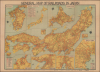
General Map of Railroads in Japan.
Postwar Revival of Japanese Railways
Choose a Collection:
- Digital Map Information
- Suitable for large format printing
- Full resolution TIFF file
- ICC color profile embedded
- Delivered instantly via download link
This Item
Enquire
Postwar Revival of Japanese Railways
This is a large-format 1947 map of Japan prepared by the country's Ministry of Transport and printed by the Geographic-Science Laboratory for the Japan Travel Bureau. Issued in the wake of World War II and during the U.S. occupation, the map highlights the country's railway network, which was heavily damaged in the final stages of the war. Starting from this inauspicious position, Japan's rail network was not only repaired but also greatly improved, thanks in large part to the demands of the Korean War (1950 - 1953). Increased investment allowed the system to embark on a program of electrification, setting the stage for the development of Japan's fantastic passenger rail system and the high-speed 'bullet trains' for which the country is internationally renowned.A Closer Look
This sheet consists of a main map, seven large insets, and three small insets. The main map covers Honshū and Shikoku, along with a small portion of Kyūshū. In addition to government trunk and branch lines, it also records railway stations, private railways (some 30 percent of the network at war's end), administrative boundaries, bus and ferry lines linking to the railway network, resorts, hot springs, and national parks. Insets at top cover Kyūshū and Hokkaidō, along with a map of principal rail lines, which are named and numbered, with railway division boundaries and regional headquarters noted. Inset maps at the bottom provide more detailed coverage of the major urban areas of Tokyo, Nagoya, and Kyoto-Osaka-Kobe, along with a map of northern Kyūshū, including the rail link between Shimonoseki and Moji (Kitakyushu) via the Kanmon Railway Tunnel. Smaller insets provide detail on the cities of Shiogama, Toyama, and Ube. The use of 'railroads' rather than 'railways' in the title and elsewhere here likely reflects U.S. influence stemming from the occupation.Historical Context
In the immediate aftermath of World War II, Japan's railway network faced severe physical destruction, depleted rolling stock, and acute shortages of coal and repair materials. Despite catastrophic conditions and deferred wartime maintenance, trains served as the country's primary lifeline, transporting millions of returning soldiers, repatriates, and starving urban residents traveling to the countryside to trade for food on the black market. This led to unprecedented overcrowding and frequent accidents, even as the Supreme Commander for the Allied Powers (SCAP/GHQ) requisitioned tracks and carriages exclusively for Allied personnel. To reduce government payrolls and stabilize public finances under the postwar Dodge Line, the state railway authority was reorganized on June 1, 1949, from a government ministry into an independent public entity: Japanese National Railways (JNR). This restructuring triggered mass layoffs, intense friction with militant labor unions, and a series of notorious, unresolved railway incidents in the summer of 1949, which highlighted the fraught social climate of the occupation era.The increased U.S. financing for war-critical industries and the resulting economic boom sparked by the Korean War in 1950 initiated a period of rapid recovery, technological renewal, and electrification. By 1956, the vital Tōkaidō Main Line (number 1 in the inset map at top-center) was fully electrified, and rolling stock shifted from heavy locomotives to lightweight, high-performance Electric Multiple Units (EMUs) featuring aerodynamic designs (led by former wartime aircraft engineers) and dynamic braking systems. By the mid-1950s, Japan's railways had not only repaired wartime damage to become the backbone of the nation's postwar economic miracle, but they had also perfected the EMU engineering and operational standards that directly enabled the birth of the world-changing Tōkaidō Shinkansen, the world's first high-speed passenger rail service, in the following years.
Publication History and Census
This map was compiled by the Ministry of Transport (運輸省) in January 1947 (Showa 22) for the Japan Travel Bureau (日本交通公社). It was printed by Morisawa Ihee (森澤伊兵衛) of the Geographic-science Laboratory (地圖科學研究所), and is also marked as 'reprinted and reissued' (飜刻發行) by Kobayashi Minorurō (小林實郎), suggesting the existence of an earlier edition, perhaps one in Japanese. This map is recorded among the holdings of four institutions in the OCLC: the University of Illinois at Urbana-Champaign, the University of South Carolina, the Library of Congress, and the University of Otago.Condition
Good. Wear along original fold lines. Creasing. Pinholing in corners.
References
OCLC 740518921.