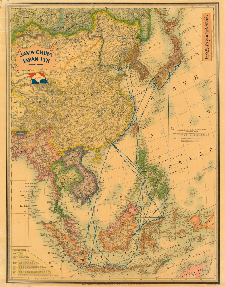
1939 Stanford Map of East Asia: Java-China Japan Steamship Line
JavaChinaJapan-stanford-1930-3$1,800.00


Title
Java-China Japan Lyn. / Map Showing Routes Ports of Call and services of the java-China Japan Line.
1930 (undated) 43.5 x 34 in (110.49 x 86.36 cm) 1 : 7000000
1930 (undated) 43.5 x 34 in (110.49 x 86.36 cm) 1 : 7000000
Description
A dramatic large-scale c. 1939 Edward Stanford map promoting the Java-China Japan (JCJL) steamship line (渣華中國日本輪船公司). It serves as a reminder of the interconnections throughout East Asia that persisted despite the geopolitical tensions in the 1930s.
A Closer Look
Coverage extends from Mongolia to Java and northern Australia and from Burma to New Guinea, embracing China, Japan, Taiwan, Southeast Asia, the East Indies, and the Philippines. Blue lines trace the routes of the JCJL through the Yellow, China, and Java Seas, while a darker line at the top indicates the Trans-Siberian and China Eastern Railways. A table of distances between major ports is provided at the bottom left. Five scales and a brief legend indicating rail and telegraph lines appear on the right.Java-China Japan Line
The Java-China Japan Line was a Dutch shipping and passenger line in East and Southeast Asia founded in 1902 by Ernst Heldring (1871 - 1954). Heldring was also the founder of several other shipping companies serving the East Indies inter-island trade, including Koninklijke Paketvaart Maatschappij (KPM), Stoomvaart Maatschappij Nederland (SMN) and Rotterdamsche Lloyd (RL). The firm maintained regular services, as illustrated here, between China, Japan, Korea, the Philippines, the East Indies, and French Indochina, despite increasing tensions between Japan and other countries, especially China, which resulted in a full-scale war by 1937. Under various names, it remained operational until 1970, when it merged with several other firms to form Nedlloyd. Java Road in Hong Kong is named after the line, which had its headquarters there in the early 20th century.Publication History and Census
This map was produced in London by Edward Stanford's Geographical Establishment - the premier mapmaker in early 20th-century London. It likely went through many iterations, of which we can find no clear breakdown. Based on the shipping routes, we estimate this map to have been issued in the 1930s. The presence of Manchukuo indicates a date of 1933 or later, while Sikang (Xikang) Province in China suggests a date in the very late 1930s. However, Beijing retains the name Peiping (Beiping), and no reference is made to the Second Sino-Japanese War (1937 - 1945), which drastically upset these shipping routes, suggesting that the map was produced in the early stages of the conflict. An example is part of the David Rumsey Map Collection. We also note examples cataloged in OCLC as part of the collections at Vrije Universiteit Amsterdam, Leiden University, and the University of Michigan, cataloged with various dates.Cartographer
Edward Stanford (May 27, 1827 - November 3, 1904) was one of the most prolific map publishing firms of the late 19th century. The company began as a partnership in 1848 between the 21 year old Edward Stanford and the established map dealer Trelawney Saunders. By 1853 the partnership had dissolved and Edward Stanford took full control of the business. A subsequent series of expansions and exciting new map issues finally led to the production of Stanford's masterwork, "Stanford's Library Map of London". This map is still available and remains somewhat accurate. At the time of publishing it was hailed by the Royal Geographical Society as "the most perfect map of London that has ever been issued". In 1882 Edward Stanford Sr. passed the firm on to his son, Edward Stanford Jr. who continued in his father's proud tradition. Today the Stanford firm still publishes maps and remains one of the most important and prolific cartographic publishers in the world. More by this mapmaker...
Condition
Good to very good. Laid on original linen. Old varnish yielding a warm tone. Tear from top edge extending about 5 inches into the map, stabilized by older repair on verso. Creasing along edge and in margin, especially at top.
References
Rumsey 10733.003. OCLC 67526940, 71570583, 238760864.