This item has been sold, but you can get on the Waitlist to be notified if another example becomes available, or purchase a digital scan.
1799 Laurie and Whittle Map of the Java Sea: Java, Sumatra, Bali, Borneo
JavaSea-lauriewhittle-1799$500.00

Title
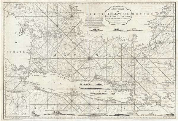
A New Chart of the Java Sea, within the Isles of Sunda; with its Straits and the Adjacent Seas.
1799 (dated) 23.24 x 34 in (59.0296 x 86.36 cm) 1 : 1950000
1799 (dated) 23.24 x 34 in (59.0296 x 86.36 cm) 1 : 1950000
Description
This is a 1799 Laurie and Whittle nautical chart or maritime map of the Java Sea. The map depicts from southern Sumatra to the Straits of Makassar and from southern Borneo to Java, Bali (Bally), Lombok, western Sumbawa, and the Indian Ocean. Centered on the Java Sea, myriad depth soundings are present, particularly along the coastal regions. Several maritime hazards, such as reefs and shoals, are noted, making this map very useful for the mariner. Also, profile views of numerous coastlines in the region are illustrated, including the appearance of Carimon, Java, Great Salombo, the 'Appearance of the Land, on the Southern Entrance of the Straits of Lombock,' and several others. These profile views would have been immensely helpful in navigation where land was often only seen from far out at sea. Numerous different locations are labeled on each of the islands, with profile views of mountains included. Rhumb lines are noted. Manuscript notations are discernable in the Straits of Sunda in the lower left quadrant. This indicates that this chart was probably used shipboard in navigation. The tracks of several ships, including the French ship Mascarin, the Warren Hastings, the Pitt and the Onslow. An note from the New York's Commercial Advisor are located to the left of the title cartouche, which detail the loss of the American ship Ontario on a reef just west of Borneo.
This map was produced by Laurie and Whittle for the 1799 edition of the East-India Pilot
This map was produced by Laurie and Whittle for the 1799 edition of the East-India Pilot
Cartographer
Laurie and Whittle (fl. 1794 - 1858) were London, England, based map and atlas publishers active in the late 18th and early 19th century. Generally considered to be the successors to the Robert Sayer firm, Laurie and Whittle was founded by Robert Laurie (c. 1755 - 1836) and James Whittle (1757-1818). Robert Laurie was a skilled mezzotint engraver and is known to have worked with Robert Sayer on numerous projects. James Whittle was a well-known London socialite and print seller whose Fleet Street shop was a popular haunt for intellectual luminaries. The partnership began taking over the general management of Sayer's firm around 1787; however, they did not alter the Sayer imprint until after Sayer's death in 1794. Apparently Laurie did most of the work in managing the firm and hence his name appeared first in the "Laurie and Whittle" imprint. Together Laurie and Whittle published numerous maps and atlases, often bringing in other important cartographers of the day, including Kitchin, Faden, Jefferys and others to update and modify their existing Sayer plates. Robert Laurie retired in 1812, leaving the day to day management of the firm to his son, Richard Holmes Laurie (1777 - 1858). Under R. H. Laurie and James Whittle, the firm renamed itself "Whittle and Laurie". Whittle himself died six years later in 1818, and thereafter the firm continued under the imprint of "R. H. Laurie". After R. H. Laurie's death the publishing house and its printing stock came under control of Alexander George Findlay, who had long been associated with Laurie and Whittle. Since, Laurie and Whittle has passed through numerous permeations, with part of the firm still extant as an English publisher of maritime or nautical charts, 'Imray, Laurie, Norie and Wilson Ltd.' The firm remains the oldest surviving chart publisher in Europe. More by this mapmaker...
Condition
Very good. Verso repairs of fold separations. Closed margin tears professionally repaired on verso. Some transferrance. Blank on verso.
References
OCLC 224985277.