This item has been sold, but you can get on the Waitlist to be notified if another example becomes available, or purchase a digital scan.
1598 De Bry / Lodewijcksz Map of the East Indies: Java, Sumatra, Malaya
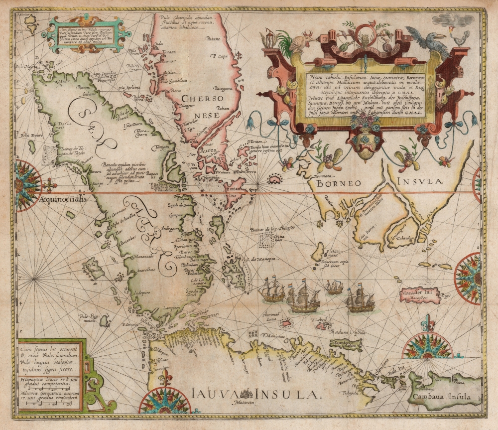
JavaSumatra-debry-1598$4,750.00

Title
Nova Tabula Insularum Javae, Sumatrae, Borneonis et Aliarum Mallaccam usquae delineate in insula Iava...
1598 (undated) 14.75 x 17 in (37.465 x 43.18 cm) 1 : 6300000
1598 (undated) 14.75 x 17 in (37.465 x 43.18 cm) 1 : 6300000
Description
This scarce, beautiful map of the East Indies is Theodore De Bry's 1598 edition of the suppressed work of Cornelis Claesz and Willem Lodewijcksz. The map represents the first Dutch voyage to the Spice Islands and thus the dawn of the Dutch ascendency as a global trade powerhouse. It is also among the earliest printed maps to include Bali.
Houtmann was better behavior at his next destination, Bali. His meeting with the Balinese monarch secured a supply pots of peppercorn. Bali is named here, but it is not on Linschoten's 1596 chart, marking this as one of the first maps to name the island.
A Closer Look
Based upon the reports of Lodewijcksz, the map embraces the East Indies From Sumatra to Borneo, and from Southern Malay (Chersonese) to Java, including the Straits of Malacca, the Straits of Singapore, and the Sunda Strait. Lodewijcksz accompanied Cornelis de Houtmann on his 1595 - 1597 voyage to the East Indies. Houtmann's ill-starred and initially unpromising voyage nevertheless signaled the Dutch entry and initial domination of the pepper trade. The chart focuses specifically on the Malacca Strait and the Sunda Strait. The former being the Portuguese-controlled route to the spice islands, and the latter being the passage to the Dutch foothold of Bantam - a tenuous trade enclave established by Houtmann on the island of Java.The Called Shot
The 1595 publication in Amsterdam of Jan van Linschoten's Reys-gheschrift vande navigatien der Portugaloysers in Orienten provided the Dutch with third first glimpse of the Portuguese overseas empire, including not only the navigational information needed access the Far East, but also descriptions of the different nations with whom the Portuguese traded. It was Linschoten who proposed the Dutch bypass the Portuguese-held Malacca Strait by navigating the Sunda Strait, between Sumatra and Java. Such a passage made the Javanese port of Bantam, situated at the eastern mouth of the Sunda Strait, an ideal foothold. Thus, when Houtmann's fleet set out in 1595, their goal was Bantam. Following a miserable passage, the fleet arrived at Bantam in June 1596.Houtmann's Journey on the Chart
A comparison of the Lodewijcksz chart with Linschoten's 1596 map points out sharp differences based on the 1595 - 1597 voyage. The Sunda Strait includes the cluster of islands which made it difficult to find the channel. While Bantam appears on Linschoten's chart amongst other towns, Lodewijcksz' identifies twice as many settlements - and, moreover, provides a wealth of inland detail, including rivers, a range of mountains to the west, and an inland city of Sura (Serang?).Exploiting Rivalries
Deeper south in Java - indeed, placed directly within the Roman Capitals for 'JAUVA INSULA' - is the city of Matarang. Although its location was not well understood, this was the capital of the Mataram Sultanate, the last major independent Javanese kingdom before Dutch colonization. While Bantam controlled the coast, the rival Mataram controlled the interior. Knowledge of the local powers was essential to the Dutch, who soon capitalized on opportunities to play one against the other.Madura and Bali
Houtmann's fleet, heading east for the Moluccas, next landed on the island of Madura, whose natives were prepared to receive them peacefully. Unfortunately, along the way the fleet had been beset by pirates, and so Houtmann unleashed his enraged crew to rape and pillage blameless Madura.Houtmann was better behavior at his next destination, Bali. His meeting with the Balinese monarch secured a supply pots of peppercorn. Bali is named here, but it is not on Linschoten's 1596 chart, marking this as one of the first maps to name the island.
Secret Knowledge
The mariner Willem Lodewijcksz, who sailed with Houtmann kept a logbook which Cornelis Claesz published in 1598 as Historie van Indien. He also engraved a chart to illustrate the voyage's findings, which was swiftly suppressed by the merchants of Amsterdam, who correctly recognized value of keeping the cartographic knowledge under wraps. Claesz would nevertheless publish the chart separately, now known in only a handful of examples. This chart, printed later that same year after the Claesz/ Lodewijcksz chart, is also very scarce. De Bry's engraving is superb and artful. The elaborate compass roses and strapwork cartouches reflect the original, although the primary cartouche's garlands and birds are De Bry's own. The four ships of Houtmann's fleet sail the waters north of Java.Publication History and Census
The present map was engraved in 1598 by Frankfurt mapmaker Theodore De Bry for inclusion in his Petits Voyages. Perhaps a dozen examples of the separate map are listed in institutional collections.CartographerS
Théodore de Bry (1528 - March 27, 1598) was an important publisher active in the mid to late 16th century. De Bry was born in 1528 in Liege, then a Prince-Bishopric and thus independent of neighboring nations. The De Bry family were accomplished jewelers and copperplate engravers and, following the family tradition, Theodore apprenticed in these fields under his grandfather Thiry de Bry senior (? - 1528), and later under his father, Thiry de Bry junior (1495 - 1590). To avoid growing religious strife in the region Théodore de Bry left Liege for the more tolerant Strasburg. Shortly afterwards, in 1577, he moved again to Antwerp and, in 1580 to London, where he became well known for his engraving skills. It was either in Antwerp or in London that De Bry befriended the English publisher and editor of traveler's tales Richard Hakluyt. Inspired by Hakluyt's work, De Bry began to collect travelers' tales, particularly of voyages to New World. His most prominent acquisition was most likely the letters and papers of the French painter and mapmaker Jacques Le Moyne de Morgues discussing a disastrous attempt by French Huguenots to colonize parts of Florida. Around, 1588 De Bry moved to Frankfurt where he began his own publishing firm. Among De Bry's earliest and most prominent publications are his Grands Voyages, a multivolume compilation of travelers' tales that included the work of Le Moyne as well as some of the earliest published depictions of the North American mainland. The firm also published various other works including an important account of early English attempts to colonize Virginia with illustrations by John White. De Bry died in Frankfurt on March 27, 1598, having never left the shores of Europe, though his name was associated throughout Europe with tales of travel and adventure. Théodore de Bry was succeeded by his son Jean-Théodore (1560 - 1623) who continued the publishing firm until his own death in 1623. More by this mapmaker...
Willem Lodewijcksz (fl. 1595 - 1598) was a Dutch mariner who accompanied Cornelis de Houtmann on his 1595-1597 voyage to southeast Asia. Upon his return, he sought out Cornelis Claesz to publish his log book in 1598 as Historie van Indien, accompanying this work with a chart detailing the islands de Houtmann visited on the journey. The map was, alas, suppressed: Dutch authorities recognized the advantage the new knowledge afforded, and forbade its publication in the book. A few examples of the Claesz were published separately, and that chart - the first detailed map of the region - proved sufficiently useful that there have been examples found annotated with navigational directions, indicating that they were actually used at sea.
In stark contrast with the importance of his book and chart, the man Lodewijcksz is unknown in every other aspect of his life. His birth, death, family, education and career following his return to the Netherlands are utterly unknown. Learn More...
Source
De Bry, T., Petits Voyages, (Frankfurt) 1598.
Condition
Very good. Reinforced at junctures of folds, few marginal mends. printers' crease at bottom center. Attractive hand color.
References
OCLC 857778292. Suarez, Thomas, Early mapping of Southeast Asia, (Hong Kong: Periplus) pp.181-182, fig. 95.