1939 Hagstrom City Plan or Map of Hoboken and Jersey City, New Jersey
JerseyCity-hagstrom-1939$800.00

Title
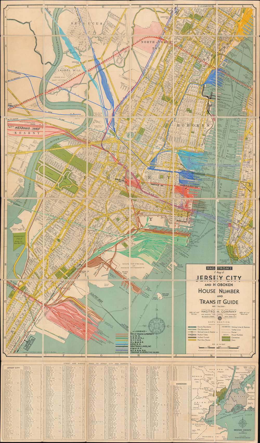
Hagstrom's Map of Jersey City and Hoboken House Number and Transit Guide Map No. 2200A
1939 (undated) 43 x 25.5 in (109.22 x 64.77 cm) 1 : 14160
1939 (undated) 43 x 25.5 in (109.22 x 64.77 cm) 1 : 14160
Description
This is a c. 1939 Hagstrom city plan or map of Jersey City and Hoboken, New Jersey, featuring manuscript notations highlighting the region's railroad network. The map depicts from the Pennsylvania Railroad freight terminal west of the Hackensack River to the western side of Manhattan and the Battery and from Union City to Bayonne. Streets are illustrated throughout, including the Lincoln Tunnel and the Holland Tunnel, with city parks, fields, and water reservoirs also labeled. Roosevelt Field, opened in 1937, was home to the minor league baseball team the Jersey City Giants. A street index for Jersey City and Hoboken is included below the bottom border, along with a small map of Hudson County and the vicinity.
Manuscript Railroad Lines
Rail lines operated by nine different railroad companies are highlighted in manuscript, with different colors used to allow for easy differentiation between them. A legend situated along the bottom border explains which color is associated with which company, with the Pennsylvania Railroad at the top. Colored in red, the Pennsylvania Railroad possesses what appears to be the largest network in the area. Other railroads highlighted here include the Lehigh Valley Railroad, the Central Railroad of New Jersey, the New York Central Railroad, the Delaware, Lackawanna and Western Railroad, the Erie Railroad, the Hudson and Manhattan Railroad, and the New York, Susquehanna and Western Railroad. Seatrain Lines, Inc., an international shipping company, also operated a small railroad near their docking facilities in Hoboken.Train Lines into New York
Only two railroads, the Pennsylvania (red) and the Hudson and Manhattan (light purple), operated tunnels across the North (Hudson) River. The Hudson and Manhattan completed their tunnels between Hoboken Terminal and 19th Street in Manhattan in 1908, two years before the Pennsylvania Railroad began running traffic through their North River Tunnels to the newly constructed Penn Station on 34th Street. As these two companies were the only two operating tunnels under the North River, most of the others operated ferries out of terminals along both banks.Publication History and Census
This map was created and published by the Hagstrom company c. 1939 and must have been commercially available, although we have been unable to locate any other examples. This example has been repurposed by the Pennsylvania Railroad to illustrate key infrastructure improvements and assist with the administration of railroad routes and ferries. As stated above, we have been unable to locate any other examples of the base Hagstrom map, but the addition of the manuscript notations surrounding the railroad network makes this piece a truly unique find.Cartographer
Andrew Gunnar Hagstrom (1890 - September 24, 1977) was a map publisher based in Maspeth, Queens. Hagstrom was a Swedish immigrant who came to new York in 1909 where took work milking cows at a farm near Coney Island, Brooklyn. He then worked in the meat packing industry while taking a degree in commercial art at the New York Mechanics Institute. Afterwords he founded a drafting business in Manhattan, creating a map to illustrate his drafting skill help customers locate his shop. His map proved popular and he expanded operations, founding the Hagstrom Map Company (1916 - 1968) and issuing additional maps of various parts of New York City and the surrounding regions. By 1949, Hagstrom had issued more than 150 maps, guides, and atlases, most of which focused on New York. Hagstrom pioneered a cartographic style that exaggerated street size to increase clarity and create additional room for large print readable labeling. Even the New York Subway system hired Hagstrom to produce its map, which was in use from the 1940s to 1958. Hagstrom died in 1977, at the age of 81. Hagstrom was knighted by the King of Sweden. His company flourished until 1968 when it was acquired by Macmillan. The brand has since passed through multiple corporate portfolios and is currently the property by Kappa Publishing Group. More by this mapmaker...
Condition
Very good. Dissected and mounted on linen in thirty-six (36) panels.