1900 Aece Hage / Rand McNally Chromolithograph View of Jerusalem
Jerusalem-aecehage-1900$2,000.00

Title
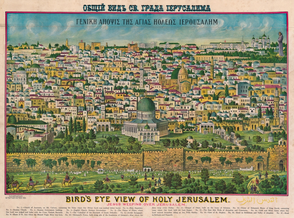
Bird's Eye View of Holy Jerusalem. Jesus Weeping Over Jerusalem. / Γενικη Αηοψις Της Αγιας Ηολεως Ιερουσαλημ. / القدس الشف
1900 (undated) 20.5 x 27.5 in (52.07 x 69.85 cm)
1900 (undated) 20.5 x 27.5 in (52.07 x 69.85 cm)
Description
A rare example of Rand McNally's 1900 chromolithograph view of Jerusalem. Although here unattributed, this view is a revised version of an earlier view issued in 1896 by the Palestinian / Syrian immigrant Aece Hage. Sometime after Hage's original printing, the view was acquired and revised by the Rand McNally Company, who updated and 'Christianized' it, adding a figure of Jesus in the upper right. They published from about 1900 both on their own account and to order - in this case, for the Chapel of Our Lady of the Cedars of Mt. Lebanon in West Roxbury, Massachusetts. The map is titled in Greek and English. Aece Hage's own title, in Arabic, also appears at the bottom right. Text below the view identifies 17 locations, which correspond to numerical assignments. The cartographer identifies Christian, Muslim, and Jewish religious sites.
The view includes most of the walled Temple Mount compound. The Dome of the Rock stands dominantly at the center; Al-Aqsa Mosque is on the left (green roof), with the small blue-roofed Cupola of the Chain situated just in front of the larger Dome of the Rock. The Western Wall, or Wailing Wall, holy to the Jewish faith, is not directly visible, but the Eastern Wall, the oldest of the visible walls around the temple mount, dating to the Herodian Period (73 BCE - 4 BCE), appears front and center.
A Masterpiece
This view is a veritable masterpiece of chromolithography, employing at least six separate plates, a feat even more remarkable when compounded by the fact that this view was initially produced in a flophouse under extenuating circumstances and on a low budget. The unusual view looks on Jerusalem from the Mount of Olives, east of the Old City, and centers on the Temple Mount and the Dome of the Rock (Qubbat al-Sakhrah), with other holy sites of multiple religions appearing behind it. In the foreground, the Eastern Wall of Jerusalem, the walled-off Golden Gate, the open Lion's Gate, and the 1400-year-old Bab-ur-Rahmah Cemetery are illustrated. The view, although stylized, is mostly accurate, suggesting that Hage (or the artist) had been to or lived in Jerusalem and drew the image from life.Temple Mount
Temple Mount, occupying the center of the image, is considered one of the Holiest places in the world and is a major pilgrimage site for all three Abrahamic religions: Judaism, Christianity, and Islam. All three religions venerate this site as the location where the Prophet Abraham stood ready to sacrifice his son Isaac. It was subsequently the site of both the First Temple (destroyed 587 BC) and the Second Hebrew Temple (516 BCE - 70 CE). Muslims believe that it was from this place that Mohammed ascended bodily to heaven - leading to the construction of the Dome of the Rock (constructed 691-92 CE).The view includes most of the walled Temple Mount compound. The Dome of the Rock stands dominantly at the center; Al-Aqsa Mosque is on the left (green roof), with the small blue-roofed Cupola of the Chain situated just in front of the larger Dome of the Rock. The Western Wall, or Wailing Wall, holy to the Jewish faith, is not directly visible, but the Eastern Wall, the oldest of the visible walls around the temple mount, dating to the Herodian Period (73 BCE - 4 BCE), appears front and center.
Palestinian / Syrian Immigration into the United States
The first wave of Arab immigration in the United States occurred between 1889 and 1914, mostly from the province of Ottoman Syria, which occupied all of today's Israel, Palestine, Lebanon, Syria, and Jordan. Hage was most certainly part of this group. While most of the 900,000 or so immigrants were Arab Christians, a minority percentage were Arab Muslims and Druze. Early immigrants settled mainly in New York and Boston. This first wave of Ottoman Syrian immigration to the United States was predominantly male, and immigrants considering themselves in the Islamic tradition of al-Nizaleh, or sojourners. Most established small businesses or became peddlers - like Hage, who owned a cookware store as of 1896. This wave of immigration continued until the Immigration Act of 1924 established a quota system, limiting all foreign immigration.Chromolithography
Chromolithography is a color lithographic technique developed in the mid-19th century. The process involved using multiple lithographic stones, one for each color, to yield a rich composite effect. Oftentimes, the process would start with a black base coat upon which subsequent colors were layered. Some chromolithographs used 30 or more separate lithographic stones to achieve the desired effect. Chromolithograph color could also be effectively blended for even more dramatic effects. The process became extremely popular in the late 19th and early 20th centuries when it emerged as the dominant method of color printing.Publication History and Census
Published about 1900 by Rand McNally - the view is here unattributed, but we note a near identical example at the Leonard and Juliet Rothman Holy Lands Map Collection, which bears the Rand McNally imprint, and date. We also are aware, from our own collections, of the original production by the Arab immigrant Aece Hage. Hage originally engraved and published this view around 1896. The address listed on the 1896 edition's imprint, 35 Edinboro Street, was at the time a boarding house of ill repute - possibly one of the few places available to the Arab immigrant. This Rand McNally variant uses the original chromolithographic stones, but it has been revised considerably to accommodate more Christian locations, adding Jesus and a Greek title. We are aware of but 3 surviving examples of this Rand McNally edition and only one known example of the original Aece Hage publication.CartographerS
Aece Hage (fl. c. 1890 - 1900) was an Arab businessman and shop owner active in Boston in the late 19th century. Little is known of Hage, but one incident, appearing in the Boston Globe (Dec 19, 1896), describes him as the owner of a 'smallware' or 'pot and pan' store at 332 Federal Street. It goes on to describe him as an 'Assyrian.' Although today Assyria generally refers to parts of present-day northern Iraq, southeastern Turkey, northwestern Iran, and western Syria; in this case, it is a reference to the Ottoman province of Greater Syria, including all of Israel, Palestine, Jordan, Lebanon, and Syria. In the late 19th century a wave of Arab Christian, Arab Muslim, and Druze immigrants, most from Palestine and Syria, came to the United States seeking a better life. Many, like Hage, established small businesses, considering themselves al-Nizaleh, or sojourners. The Boston Globe article in question, the only reference to Hage we have found, describes a robbery in which Hage was burgled of 40 USD by a fellow 'Assyrian', Nasim M. Asseese. The short article further notes that both Hage and Asseese were 'locked up.' More by this mapmaker...
Rand, McNally and Co. (fl. 1856 - present) is an American publisher of maps, atlases and globes. The company was founded in 1856 when William H. Rand, a native of Quincy, Massachusetts, opened a print shop in Chicago. Rand hired the recent Irish immigrant Andrew McNally to assist in the shop giving him a wage of 9 USD per week. The duo landed several important contracts, including the Tribune's (later renamed the Chicago Tribune) printing operation. In 1872, Rand McNally produced its first map, a railroad guide, using a new cost effective printing technique known as wax process engraving. As Chicago developed as a railway hub, the Rand firm, now incorporated as Rand McNally, began producing a wide array of railroad maps and guides. Over time, the firm expanded into atlases, globes, educational material, and general literature. By embracing the wax engraving process, Rand McNally was able to dominate the map and atlas market, pushing more traditional American lithographic publishers like Colton, Johnson, and Mitchell out of business. Eventually Rand McNally opened an annex office in New York City headed by Caleb S. Hammond, whose name is today synonymous with maps and atlases, and who later started his own map company, C. S. Hammond & Co. Both firms remain in business. Learn More...
Condition
Very good. Crease across 1/8th, below title. Minor repair near upper title. Slight margin soiling.
References
OCLC 993090548. Stanford University, The Leonard and Juliet Rothman Holy Lands Map Collection, 11543728.