
1948 Hebrew Association Plan of Jerusalem

This item has been sold.
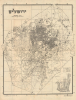
ירושלים / [Jerusalem].
Jerusalem on the Eve of Partition.
Choose a Collection:
- Digital Map Information
- Suitable for large format printing
- Full resolution TIFF file
- ICC color profile embedded
- Delivered instantly via download link
This Item
Enquire
Jerusalem on the Eve of Partition.
This is a scarce c. 1948 map of Israel produced by the Hebrew Association for Jerusalem. It presents the city after a period of significant Jewish immigration, to western Jerusalem in particular, depicting it as it existed on the eve of the foundation of the State of Israel.A Closer Look
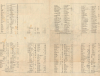
The map covers the urban area of Jerusalem with the Old City clearly visible at right-center. Streets, neighborhoods, parks, cemeteries, and other landmarks are labelled. Many more sites are indicated with a number corresponding to two indexed on the verso, which also provide coordinates according to a grid surrounding the map. An inset map at bottom-right depicts 'Jerusalem in Ancient Times' (ירושלים בימי קדם), displaying the location of several historical walls, up to and including the still-extant walls built in the 16th century.Jerusalem in the Late Mandatory Period
This map was produced at the end of the era of the British Mandate for Palestine (1920 - 1948). Despite periods of suppression and expulsion, there was a Jewish presence in Jerusalem for many centuries, and under the Ottomans, Jews were generally accepted and given autonomy (dhimmi status), at the cost of a special tax and legal limitations. In the mid-to-late 19th century, Jewish immigration to Palestine and Jerusalem increased substantially, with immigrants primarily coming from Eastern Europe and other parts of the Middle East. These new arrivals often had difficulty integrating, even among the extant Jewish communities of Jerusalem. As a result, several Jewish settlements sprang up on the western edge of the city. By the early Mandatory Period (1922 - 1948), there was a consolidated 'Jewish Colony' around what is now called the Downtown Triangle, formed by Jaffa Road (רחוב יפו), Ben Yehuda Street (רחוב בן יהודה), and King George Street (רח המלך ג׳ורג׳), the area around number 96 on the map, the Kupat Am Bank (בנק קופת עם).Although British policy was confused and even contradictory, it generally encouraged Jewish migration to Palestine. Both due to the growing Jewish population and from their own imperial hubris to 'rebuild' the holiest of all cities, British urban planners and colonial officials began floating ideas for remaking Jerusalem. In 1918, William McLean proposed an urban plan that would preserve the Old City and other historical sites while constructing wide boulevards on a mostly geometric grid in western Jerusalem, in the style of European and American city planning of the era, complete with zoning. In the following decades, Patrick Geddes (1919, who also planned Tel Aviv and designed the Hebrew University of Jerusalem campus), Clifford Holliday (1930), and Henry Kendall (1940) proposed updated urban plans that stuck to McLean's general principles but planned for even more development in western Jerusalem, effectively shifting the city's center of gravity westwards, away from the Old City.
This effective bifurcation of the city inadvertently laid the groundwork for the division of Jerusalem between 1948 and 1967 due to the Arab-Israeli conflict. As efforts to forestall an Arab-Jewish conflict were undertaken in the wake of World War II (1939 - 1945), the United Nations proposal for Palestine aimed to make Jerusalem an international city to avoid its division. However, in the course of the 1948 conflict, what had been a city with a degree of integration became entirely segregated. For example, nearly 30,000 Arabs lived in western Jerusalem before the conflict, and afterwards only a handful remained. Similar displacements of smaller groups of Jewish settlers in eastern Jerusalem also occurred. As the 1948 conflict wound down and ceasefires and then armistices came into effect, the city was divided along the 'green line' - an arbitrary ceasefire line that nearly followed the effective division of western and eastern Jerusalem along religious and ethnic lines. In the following years, Israel moved its capital to West Jerusalem (a move only recognized by other countries in recent years) and invested heavily in building up the city. Even after Israel occupied East Jerusalem (and the West Bank writ large) in the 1967 Six-Day War, the city has remained largely segregated along east-west lines.
The First Arab-Israeli War
The founding of the nation of Israel resulted from decades-long processes but culminated dramatically in 1947 - 1949 with widespread communal violence along with more conventional warfare between armies. An attempt by the United Nations to negotiate a peaceful devolution of the British Mandate of Palestine failed, and violence between Jews and Palestinians increased in 1947 - 1948, with Jewish militias gaining an upper hand and many Palestinians fleeing. As the British left in May 1948, Israel declared its independence, after which it was invaded by the surrounding Arab states. After months of fierce fighting, Israeli forces pushed back the Arab armies, and a series of armistice agreements ended the conflict. For Palestinians, the conflict was the opening phase of the Nakba or 'Catastrophe', in which roughly 80% of the Palestinian population was forced into exile. The events of 1948 laid the foundation for the ongoing ethnic and religious conflict in Israel-Palestine and wider regional destabilization.Publication History and Census
This map was prepared by the Hebrew Association for Jerusalem (האגודה העברית למען ירושלים, not to be confused with the Pro-Jerusalem Society האגודה למען ירושלים founded by British military governor Sir Ronald Storrs) in 1947 or 1948. It was provided as a separately-issued supplement to the Encyclopedia of the Land of Israel (נספח לאנציקלופדיה ארץ ישראל, כרך שני) edited by Yeshayahu Press (ישעיהו פרס, 1874 - 1955). The map (dated 1947 or 1948) is only independently cataloged among the holdings of the Library of Congress, Yeshiva University, and the National Library of Israel.Condition
Very good. Slight wear on old fold lines.
References
OCLC 233306704, 1119065429 (dated 1948).