
This item below is out of stock, but another example (left) is available. To view the available item, click "Details."
Details
1598 Munster View / Map of Jerusalem
$750.00
1598 Munster View / Map of Jerusalem
Jerusalem-munster-1550$475.00


Title
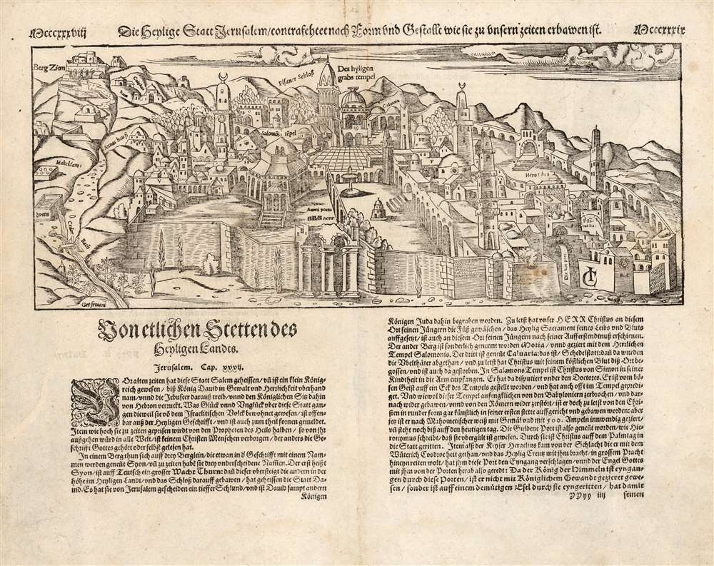
Die heylige Statt Ierusalem / contrafehtet nach Form und Gestallt wie sie zu unsern zeiten erbawen ist.
1550 (undated) 10.75 x 14.75 in (27.305 x 37.465 cm)
1550 (undated) 10.75 x 14.75 in (27.305 x 37.465 cm)
Description
One of the earliest printed views of Jerusalem, executed in woodcut by Jacob Clauser for Sebastian Munster's Cosmographia, from a 1598 German edition. Unlike most early depictions, this bird’s-eye view is not a purely retrospective depiction of the ancient city, but rather a modern view, showing the city at the time of publication. As explained in the view's title, it is meant to depict the Holy City in the 'form and shape as it was built in our times'. In its initial 1550 printing, this was one of the earliest contemporaneous images of the city.
The map is the design of a devout Christian, and so many of the features emphasized would be of primary interest to Christian pilgrims, whether actual or armchair travelers. Named are Mount Zion, the Church of Saint Anne, and King David's Tomb. The temple of the Knights of the Holy Sepulchre is shown. The court of Pilate, the palace of Herod, the Garden of Gesthemane, and the Akeldama are also marked. At the time, Jerusalem was occupied by the Ottoman Empire. As such, the Dome of the Rock is depicted centrally, and is clearly a mosque, but retains the name of the 'Temple of Solomon'. The whole of the city is embraced by its ancient walls, with several of its iconic gates named.
The map is the design of a devout Christian, and so many of the features emphasized would be of primary interest to Christian pilgrims, whether actual or armchair travelers. Named are Mount Zion, the Church of Saint Anne, and King David's Tomb. The temple of the Knights of the Holy Sepulchre is shown. The court of Pilate, the palace of Herod, the Garden of Gesthemane, and the Akeldama are also marked. At the time, Jerusalem was occupied by the Ottoman Empire. As such, the Dome of the Rock is depicted centrally, and is clearly a mosque, but retains the name of the 'Temple of Solomon'. The whole of the city is embraced by its ancient walls, with several of its iconic gates named.
Publication History and Census
Munster's Cosmographia Universalis was published in German in 1544, the first of many editions. Most of the city views associated with the Cosmographia were not added until 1550, including the present view of Jerusalem by Jacob Clauser. The present example conforms typographically to the 1598 Cosmographia, published by Sebastian Petri. Munster's work was extremely popular, running to over fifty thousand copies over a long printing history. The book is well represented in institutional collections, and examples of its individual sheets occasionally appear on the market, often in widely varying condition.CartographerS
Sebastian Münster (January 20, 1488 - May 26, 1552), was a German cartographer, cosmographer, Hebrew scholar and humanist. He was born at Ingelheim near Mainz, the son of Andreas Munster. He completed his studies at the Eberhard-Karls-Universität Tübingen in 1518, after which he was appointed to the University of Basel in 1527. As Professor of Hebrew, he edited the Hebrew Bible, accompanied by a Latin translation. In 1540 he published a Latin edition of Ptolemy's Geographia, which presented the ancient cartographer's 2nd century geographical data supplemented systematically with maps of the modern world. This was followed by what can be considered his principal work, the Cosmographia. First issued in 1544, this was the earliest German description of the modern world. It would become the go-to book for any literate layperson who wished to know about anywhere that was further than a day's journey from home. In preparation for his work on Cosmographia, Münster reached out to humanists around Europe and especially within the Holy Roman Empire, enlisting colleagues to provide him with up-to-date maps and views of their countries and cities, with the result that the book contains a disproportionate number of maps providing the first modern depictions of the areas they depict. Münster, as a religious man, was not producing a travel guide. Just as his work in ancient languages was intended to provide his students with as direct a connection as possible to scriptural revelation, his object in producing Cosmographia was to provide the reader with a description of all of creation: a further means of gaining revelation. The book, unsurprisingly, proved popular and was reissued in numerous editions and languages including Latin, French, Italian, and Czech. The last German edition was published in 1628, long after Münster's death of the plague in 1552. Cosmographia was one of the most successful and popular books of the 16th century, passing through 24 editions between 1544 and 1628. This success was due in part to its fascinating woodcuts (some by Hans Holbein the Younger, Urs Graf, Hans Rudolph Manuel Deutsch, and David Kandel). Münster's work was highly influential in reviving classical geography in 16th century Europe, and providing the intellectual foundations for the production of later compilations of cartographic work, such as Ortelius' Theatrum Orbis Terrarum Münster's output includes a small format 1536 map of Europe; the 1532 Grynaeus map of the world is also attributed to him. His non-geographical output includes Dictionarium trilingue in Latin, Greek, and Hebrew, and his 1537 Hebrew Gospel of Matthew. Most of Munster's work was published by his stepson, Heinrich Petri (Henricus Petrus), and his son Sebastian Henric Petri. More by this mapmaker...
Jacob Clauser (1520?-1579?) was a Swiss draftsman, painter and designer for woodcuts. Many of his illustrations appeared in Münster's 'Cosmographia'. Born in Zurich, he was active in the Upper Rhine and Lake Constance region. Learn More...
Heinrich Petri (1508 - 1579) and his son Sebastian Henric Petri (1545 – 1627) were printers based in Basel, Switzerland. Heinrich was the son of the printer Adam Petri and Anna Selber. After Adam died in 1527, Anna married the humanist and geographer Sebastian Münster - one of Adam's collaborators. Sebastian contracted his stepson, Henricus Petri (Petrus), to print editions of his wildly popular Cosmographia. Later Petri, brought his son, Sebastian Henric Petri, into the family business. Their firm was known as the Officina Henricpetrina. In addition to the Cosmographia, they also published a number of other seminal works including the 1566 second edition of Nicolaus Copernicus's De Revolutionibus Orbium Coelestium and Georg Joachim Rheticus's Narratio. Learn More...
Source
Munster, S., Cosmographey: das ist, Beschreibung Aller Länder... (Basel: Petri) 1598.
Condition
Very good. Some faint staining. Two small mended holes away from printed image.
References
OCLC 234170839 (1550). Laor, E., Maps of the Holy Land: Cartobibliography of Printed Maps, 1475 - 1900, #1087 (1550).