1726 Stocklein / du Halde Map of Jesuit Missions, Peru and Bolivia
JesuitPeru-stocklein-1726$350.00

Title
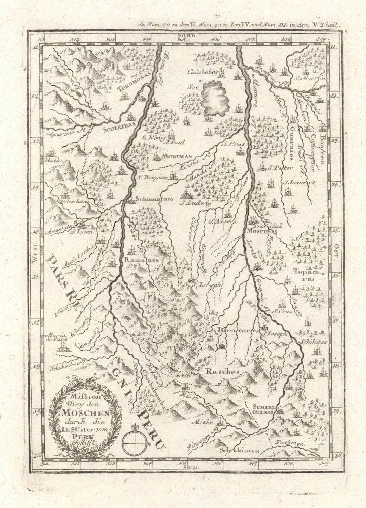
Mission bey den Moschen durch die IESUiter von Peru Gestifft.
1726 (undated) 8.5 x 6 in (21.59 x 15.24 cm) 1 : 9500000
1726 (undated) 8.5 x 6 in (21.59 x 15.24 cm) 1 : 9500000
Description
This is an influential c. 1726 map of the Beni in Bolivia and surrounding areas, which appeared in Joseph Stöcklein's Der Neue Weltbott. Based on a c. 1713 manuscript map, it is a critically important map in the cartography of this part of South America, serving as the basis for later maps of the region for years afterwards.
In any event, while geographically close to Peru, the Moxos mission was part of the Spanish Viceroyalty of Peru. It was among the last areas of South America outside of Amazonia proper to be reached by missionaries, owing to its remoteness from the coast. Still, once established in the region (at the end of the 17th century), the Jesuits and their mission played a major role in transforming both the religious and cultural life of indigenous groups in the lowlands.
A Closer Look
This map covers portions of modern southeastern Peru and northern Bolivia, centered on the Beni, the remote, low, flatlands situated between the Andes and the Amazon. The map is defined by two large rivers, the Beni and the Mamoré, arteries of a massive network of waterways that ebb and flow with the seasons. Mountains, tributary waterways, and settlements are noted throughout. Missions and many cities bear Christian names, mostly named after saints, while some retain their indigenous names, including Cusco (Guzko) at left, previously the resplendent capital of the Inca Empire. As with 'Moxos' itself, several toponyms employed here were in fact ethnonyms, a common misunderstanding in early European colonial maps.A Seminal Map
As explained in Mirela Altic's 2022 book Encounters in the New World: Jesuit Cartography of the Americas, this map is based on an anonymous manuscript that was most likely compiled in 1713, when the Jesuit presence in the region was still highly tenuous. Although originally containing some errors (later amended), the 1713 map 'served as the main cartographic source for the representation of the Province of Moxos for a very long time,' being republished in Jesuit publications (including Stöcklein's) and beyond for decades afterwards. The map as it appears in Stöcklein's Neue Weltbott is based on a 1717 modification undertaken by Jean-Baptiste du Halde when he prepared it for publication in the Jesuit journal Lettres édifiantes, turning the map to orient it with north at top instead of east, shrinking it, and making several other changes. In translating the map from French to German, Stöcklein then made a few minor modifications of du Halde's map, resulting in the work seen here.The Jesuits' Moxos Mission
The Jesuit Moxos mission was a remarkable missionary effort in the Moxos region, located mostly in the present-day Beni Department, Bolivia, on the southwestern edge of the Amazon basin. This seasonally flooded plain was home to numerous indigenous groups like the Moxo (Mojo), Baure, Canichana, Trinitario, who, recent research has revealed, built huge, advanced earthworks that suggest the region supported a much larger pre-Columbian population than previously assumed.In any event, while geographically close to Peru, the Moxos mission was part of the Spanish Viceroyalty of Peru. It was among the last areas of South America outside of Amazonia proper to be reached by missionaries, owing to its remoteness from the coast. Still, once established in the region (at the end of the 17th century), the Jesuits and their mission played a major role in transforming both the religious and cultural life of indigenous groups in the lowlands.
Publication History and Census
This map appeared in Stöcklein's Der Neue Weltbott mit allerhand Nachrichten dern Missionariorum Societatis Jesu, published between 1728 and 1758 (the map itself is generally dated to 1726). It is not independently cataloged with any institution, while Stöcklein's entire work is rare in institutional collections and on the market.CartographerS
Joseph Stöcklein [Stoecklein] (July 30, 1676 – December 28, 1733) was a Jesuit priest, missionary, and scholar active in the late 17th and early 18th centuries. He was born in Oettingen, Germany and joined the Jesuit order in Vienna around 1700. He served as a priest in military encampments where he became popular as a preacher. Afterwards he became the head of the Jesuit library in Graz, Switzerland, a position he maintained for six years. During this tenure he began work on his opus, the Welt-Bott, a vast compilation of Jesuit missionary letters and narratives translated into vernacular German intended both to glorify the priesthood and share valuable information about the world. Today this work is exceedingly rare. More by this mapmaker...
Jean-Baptiste du Halde (杜赫德; February 1, 1674 – August 18, 1743) was a French Jesuit historian and geographer. Although he was not part of the Jesuits' China mission, he did collect letters, memoirs, and other information from the Jesuits in China to publish the work Geographical, Historical, Chronological, Political, and Physical Description of the Empire of China and Chinese Tartary in 1735, which had a significant influence throughout Europe for decades afterwards. Among those it inspired was Jean Baptiste Bourguignon d'Anville, who used du Halde's descriptions (based on a land survey under the Kangxi Emperor that the Jesuits were involved in) to draw his famous map of China, which was the gold standard in Europe into the 19th century. Learn More...
Source
Stocklein, J., Neuer Welt-bott..., (Augsburg: Grätz) 1728.
Condition
Excellent.
References
Altić, M., Encounters in the New World: Jesuit Cartography of the Americas, (Chicago: The University of Chicago Press) 2022, pp. 141 - 155.