1934 Burpitt Plat Map of Part of Johnson Estates, Atlanta, Georgia
JohnsonEstatesAtlanta-burpitt-1934$750.00

Title
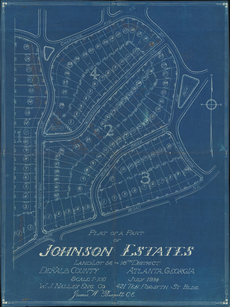
Plat of a Part of Johnson Estates Land Lot 56 18th District DeKalb County Atlanta, Georgia.
1934 (dated) 21.5 x 16.25 in (54.61 x 41.275 cm) 1 : 1200
1934 (dated) 21.5 x 16.25 in (54.61 x 41.275 cm) 1 : 1200
Description
This is a rare 1934 James W. Burpitt cyanotype plat map of Johnson Estates, Atlanta, Georgia. It is the earliest known map of Johnson Estates, appearing early in the neighborhood's development. Today, Johnson Estates is one of Atlanta's most desirable neighborhoods.
A Closer Look
The map illustrates Johnson Estates between Charline Avenue NE and Johnson Road and Homestead Avenue and Meadowdale Avenue - thus appearing much as it does today. The neighborhood is subdivided into lots, each labeled with dimensions. Hickory Grove Park is projected, although it has yet to be named. Homestead Park and Noble Park appear in the planning stages, although today's parks differ from what is illustrated here.Johnson Estates
Development of Johnson Estates began in 1930, along with Noble Park and Hylan Park. Lenox Park opened the following year. Today, Johnson Estates is part of Morningside/Lenox Park.Cyanotype: Why so Blue?
Cyanotype is a photo-reprographic technique developed in 1842 by the British astronomer John Herschel (1792 - 1871). Sometimes called a 'sunprint', the technique employs a solution of ferric ammonium citrate and potassium ferricyanide, which painted on white paper or cloth, reacts when exposed to sunlight to dye the object a brilliant blue. Areas blocked from ultraviolet exposure remain undyed and white. Herschel developed the technique to reproduce his astronomical notes, but others quickly realized that any object capable of blocking light could be used to create a cyanotype image quickly and easily. By the late 19th century, the process became popular with designers, military, architects, and engineers (blueprints), who used the cheap and effective technique to quickly and exactly reproduce images in the field. Cyanotyping is limited in that only a single copy can be made at one time, so it was only practical for short-term field work. It is also of note that cyanotypes remain extremely reactive to light and, over time, fade or degrade, making them extremely ephemeral. The process fell out of fashion in most places by the 1920s but remains in use in some parts of the world, such as India and Nepal, to this day.Publication History and Census
This map was drawn by James W. Burpitt and published in July 1934 by the W. J. Nalley Engineering Company. The only reference we have unearthed is a legal notice from DeKalb County, Georgia, concerning the sale of a plot of land that appears on the present map and references Burpitt's plat. The legal notice does not say where the plat map they referenced is kept, likely in the DeKab County archives or that of another government body in Georgia.Cartographer
James William Burpitt (June 12, 1900 - October 24, 1982) was an American civil engineer and Army officer. Born in Atlanta, Georgia, Burpitt attended high school in Atlanta before attending the Georgia School of Technology (Georgia Tech) and graduated in 1922. While at Georgia Tech, Burpitt was part of the R.O.T.C. program and was commissioned as an officer even before graduation. In February 1942, when Burpitt filled out his Selective Service Registration Card, he was working for himself as a civil engineer. By 1944, he served in the Army Corps of Engineers and had reached the rank of captain. After the war, Burpitt stayed in the Army and helped build military cemeteries in Paris, France. At one point, he was assigned to (worked for?) the American Battle Monuments Commission. Burpitt retired from the Army as a lieutenant colonel. After retirement, he split his time between Atlanta and Nokomis, Florida. He married Pauline Landon Burpitt on June 20, 1925, with whom he had two daughters. More by this mapmaker...
Condition
Very good. Light wear along original fold lines. Punctures and discoloration in lower left corner from removed rusty staple.