This item has been sold, but you can get on the Waitlist to be notified if another example becomes available.
1963 General Drafting World Map of Historical Exploration, Space Race
JourneysOfDiscovery-generaldrafting-1963$100.00


Title
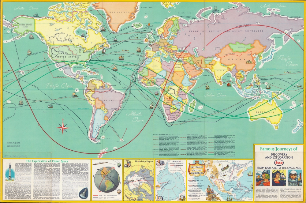
Famous Journeys of Discovery and Exploration from 1000 A.D. to the Space Age.
1963 (dated) 22.75 x 34 in (57.785 x 86.36 cm) 1 : 40000000
1963 (dated) 22.75 x 34 in (57.785 x 86.36 cm) 1 : 40000000
Description
An inspirational 1963 map by General Drafting depicting voyages of discovery and exploration. It was made in the midst of the space race between the United States and Soviet Union, and more specifically, was prompted by the orbital space flights of Yuri Gagarin and John Glenn.
However, the map's main focus and impetus are the orbital flights of Yuri Gagarin in April 1961 and the first American orbital flight by John Glenn in February 1962. At the bottom is a legend of all the journeys of discovery depicted, along with text and inset maps discussing the exploration of the North and South Poles, Early Spanish and French explorations of North America, and the contemporary Space Race.
A Closer Look
The world is displayed with countries color-shaded. On the oceans, ships represent the voyages of great European explorers, from Leif Ericsson, through Columbus, Vasco de Gama, James Cook, and to the polar explorations of the late 19th century. Several 20th-century voyages are also depicted, including Roald Amundsen's successful charting of the Northwest Passage, the Lucky Lady II, a U.S. Air Force Boeing B-50 Superfortress that in 1949 became the first airplane to circle the world nonstop, the Pacific voyage of Thor Heyerdahl, which demonstrates the ability of ancient Polynesians to have crossed the Pacific.However, the map's main focus and impetus are the orbital flights of Yuri Gagarin in April 1961 and the first American orbital flight by John Glenn in February 1962. At the bottom is a legend of all the journeys of discovery depicted, along with text and inset maps discussing the exploration of the North and South Poles, Early Spanish and French explorations of North America, and the contemporary Space Race.
'Friendship 7' and the Space Race
At this point in the Space Race, the U.S. was desperately trying to catch up to the Soviets, who enjoyed an early advantage. Although Alan Shepard was sent into space in May 1961, his sub-orbital parabolic flight path was less impressive than Gagarin's full orbit of the Earth. In August 1961, Gherman Titov orbited the Earth 17 times on Vostok 2, far surpassing Glenn's later three orbits, and soon after Glenn's flight, Valentina Tereshkova became the first woman in space, orbiting the Earth 48 times. Nevertheless, Glenn's flight was an important confidence boost for the still-young NASA and encouraged further government investment in space flight, allowing the Americans to gain the upper hand by the end of the decade.Publication History and Census
This map was prepared by General Drafting Co. in 1963 in conjunction with the petroleum company Esso (previously Standard Oil of New Jersey). It is noted among the holdings of 14 institutions in the OCLC.Cartographer
General Drafting Corporation (1909 - 1992) was one of the 'Big Three' publishers of road maps between 1930 and 1970, along with H. M. Gousha and Rand McNally. Founded in 1909, Otto G. Lindberg, an immigrant from Finland and the company's founder, began his business with a borrowed drafting board and a $500 loan from his father. At the time only twenty-three years old, Lindberg advertised his business as 'any and all general drafting' and was based out of 170 Broadway in New York City. Only two years later, in 1911, the firm secured its first contract from the American Automobile Association to make 'road maps'. Lindberg incorporated his business in 1914 and became its first Chairman of the Board, a position he held until his death in 1968. Lindberg persuaded Standard Oil of New Jersey to let him draw the 'best' road map of the state that they had ever seen, and Standard Oil would distribute it for free. Sufficiently impressed with the finished product, Standard contracted General Drafting to make all their road maps - a relationship that lasted another six decades. This relationship allowed General Drafting to work exclusively for Standard Oil, but when oil companies stopped providing free maps, General Drafting was in a bind. The company tried to expand into the retail map market, and it of course continued creating maps for Exxon (the new name for Standard Oil) to sell, but its returns continued to decline. The firm was purchased in 1992 by Langenscheidt and subsequently absorbed into the American Map Company. General Drafting's state maps became this company's 'Travelvision' lineup. More by this mapmaker...
Condition
Very good. Light wear along original folds.
References
OCLC 12764136.