This item has been sold, but you can get on the Waitlist to be notified if another example becomes available, or purchase a digital scan.
1884 Sargent Forestry Map of the United States Depicting Walnut Trees
Juglans-sargent-1884$162.50

Title
Map Showing the Distribution of the Genus Juglans (the Walnuts) in North America. Exclusive of Mexico.
1884 (undated) 19 x 28 in (48.26 x 71.12 cm) 1 : 7000000
1884 (undated) 19 x 28 in (48.26 x 71.12 cm) 1 : 7000000
Description
This is an 1884 Charles Sprague Sargent arboreal thematic map of North America. The map depicts the United States from Canada to Mexico and from the Pacific Ocean to the Atlantic Ocean. It was part of a portfolio entitled Sixteen Maps Accompanying Report on Forest Trees of North America, which accompanied the 1884 Department of the Interior Report on Forests of North America (Exclusive of Mexico), itself a part of the United States Census of 1880.
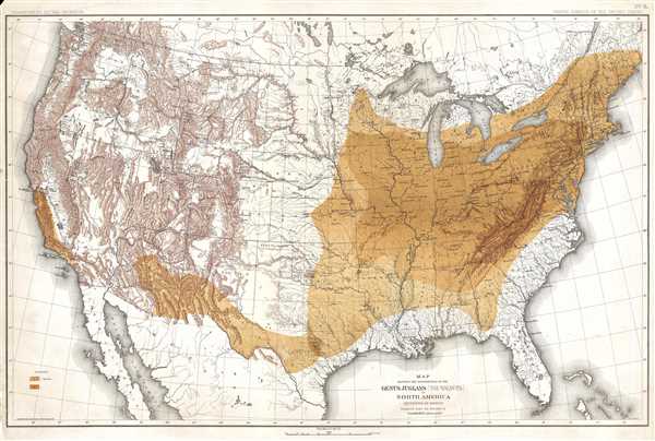
As title suggests, the purpose of this map is to illustrate the distribution of Genus Juglans, or walnut trees, throughout the United States. A legend along the left border explains that the two different colors present on the map relate to the different species of walnut trees indigenous to the region. Per the map, walnut trees are common in the eastern half of the United States, in the southwest, and coastal California. The coloring indicates that the second species of walnut tree is native to the Midwest, while the species I, as noted on the map, rings the range of species II, and is also present in the southwest and California.
Although created to illustrate the distribution of walnut trees, several other aspects of the geography of North America are also depicted. Myriad rivers are labeled, as well as all the contemporary states, which at the time included the Indian Territory and Dakota as well as the Alaska Territory. It is worth noting that the land that will become the panhandle of Oklahoma is labeled here as 'public lands'. State capitals and other major cities are labeled. Mountain ranges are depicted.
This map was prepared under the direction of Charles Sprague Sargent, drafted by Harry King, and compiled under the direction of Henry Gannett. The map is number five of the portfolio titled Sixteen Maps Accompanying Report on Forest Trees of North America, which accompanied the 1884 Department of the Interior Report on Forests of North America (Exclusive of Mexico), and was published by Julius Bien in New York.
CartographerS
Charles Sprague Sargent (1841-1927) was an American botanist who was the first director of Harvard's Arnold Arboretum, a post which he held for 54 years. Sargent graduated from Harvard College in 1862 with a degree in Biology and immediately joined the United States Army and served in Louisiana during the Civil War. Following his time in the army, Sargent spent three years touring the botanical gardens of Europe. Upon his return, he took it upon himself to care for the grounds of his family estate, Holm Lea in Brookline, Massachusetts. In 1872, Sargent was appointed as a professor of horticulture at the newly formed Bussey Institution and in 1873 was named Director of the Arnold Arboretum. The Arboretum slowing began to take shape in the years following his appointment, and, beginning in 1878, Sargent began working with the renowned landscape architect Frederick Law Olmstead on a path and roadway system. In 1880, Sargent's expertise was called upon by the Department of Forestry to conduct a census of the trees of the United States by region, which was published in 1884 as Report on the Forests of North America (exclusive of Mexico). Sargent was influential in the creation of both national forests and national parks over the course of his career. It is said that Sargent spent all his waking hours either working in the administration building that he had raised the funds to have built, or wandering the grounds of the Arboretum. His expertise was renowned, even his own staff considered him to be a 'one-man institution'. After Sargent's death in 1927, Massachusetts Governor Alvan T. Fuller planted a white spruce on the grounds of the Massachusetts State House in his memory, stating, 'Professor Sargent knew more about trees than any other living person. It would be hard to find anyone who did more to protect trees from the vandalism of those who do not appreciate the contribution that they make to the beauty and wealth of our nation.' More by this mapmaker...
Henry Gannett (August 24, 1846 - November 5, 1914) was an American geographer who is described as the 'Father of American topographic map making'. Born in Bath, Maine, Gannett entered Harvard at the age of twenty and received a bachelor's degree in 1869. He earned the degree of mining engineer from the Hooper Mining School in 1870. He joined the Hayden Survey in 1871, at the age of twenty-one, and continued worked for its successor, the U.S. Geological Survey until his death. Gannett was among those lobbying to centralize all government mapmaking under one agency. Before the creation of the United States Geological Survey, individual mapmakers and agencies had to compete for money from Congress to fund projects. He became chief geographer of the U.S. Geological Survey, a position he held for fifteen years. Most of the Survey's map-making methods developed during his tenure as chief geographer. Gannett also earned a reputation as an indefatigable compiler of geographic materials. His first job with the USGS was geographer of the 1880 United States Census. The completion of the census in 1882 is considered the start of true topographical work in the United States and the birth of the quadrangle. Gannet served as chief geographer on two subsequent censuses, 1890 and 1900, and was one of the founding members of the National Geographic Society. Gannett was also one of the founders of the Association of American Geographers and the Geological Society of America. Gannet organized the Board of Geographic Names, which became a permanent part of the federal government and considers geographic names in official use. Gannett served as chairman of this Board from 1894. Upon his death, the Annals of the Association of American Geographers lamented, 'in the death of Henry Gannett American Science has lost one of the pioneers who had an important share in the development of geography in this country into an organized science'. Gannett married Mary E. Chase in 1874 with whom he had two daughters and a son. Learn More...
Julius (Julien) Bien (September 27, 1826 - December 21, 1909) was a German-Jewish lithographer and engraver based in New York City. Bien was born in Naumburg, Germany. He was educated at the Academy of Fine Arts, Cassell and at Städel's Institute, Frankfurt-am-Main. Following the suppression of the anti-autocratic German Revolutions of 1848, Bien, who participated in the pan-German movement, found himself out of favor in his home country and joined the mass German immigration to the United States. Bien can be found in New York as early as 1849. He established the New York Lithographing, Engraving & Printing Company in New York that focused on the emergent chromo-lithograph process - a method of printing color using lithographic plates. His work drew the attention of the U.S. Government Printing Office which contracted him to produce countless government maps and surveys, including the Pacific Railroad Surveys, the census, numerous coast surveys, and various maps relating to the American Civil War. Bien also issued several atlases both privately and in conjunction with a relation, Joseph Bien. At the height of his career Bien was elected president of the American Lithographers Association. After his death in 1909, Bien's firm was taken over by his son who promptly ran it into insolvency. The firm was sold to Sheldon Franklin, who, as part of the deal, retained the right to publish under the Julius Bien imprint. In addition to his work as a printer, Bien was active in the New York German Jewish community. He was director of the New York Hebrew Technical Institute, the New York Hebrew Orphan Asylum, and president of the B'nai B'rith Order. Learn More...
Source
Sargent, C.S., Sixteen Maps Accompanying Report on Forest Trees of North America (New York: Bien) 1884.
Condition
Very good. Light soiling. Even overall toning. Small verso repairs along margin. Blank on verso.
References
Rumsey 2332.006. OCLC 431578516.