1854 Grieve / Indian Navy Nautical Chart of Karachi, Pakistan
Karachi-grieve-1854$6,000.00


Title
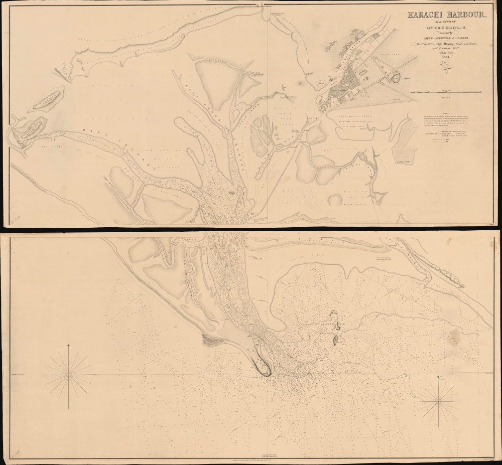
Karachi Harbour, surveyed by Lieut. A. M. Grieve, I.N. Assisted by Lieuts. Constable and Barker.
1854 (dated) 53 x 56 in (134.62 x 142.24 cm) 1 : 9000
1854 (dated) 53 x 56 in (134.62 x 142.24 cm) 1 : 9000
Description
A seminal 1854 large-scale Indian Navy Albany M. Grieve nautical map of Karachi Harbor, in the Sindh region of what is today Pakistan. This is the second and certainly the largest map of Karachi, and the first as an East India Company port. It was issued in the same year that marked Karachi Harbor's opening to EIC traders and the completion of the connecting Napier Mole causeway - illustrated here.
Although adventurers and the India Navy occasionally visited Karachi, it was not occupied by the British East India Company until February 1839, and did not fall fully under British suzerainty until after the 1843 Battle of Miani, in which the EIC effectively took control of Sindh. One year later, in 1844, as the EIC began to implement its grand plans for Karachi, the Carless survey was finally published - only one example of which survives (sold previously by Geographicus).
In the decade between 1844, this map's 1854 publication, and Karachi's opening as a port in the same year, we recognize significant advancement, both in terms of the cartographic and hydrographic understanding of the coastal plain and infrastructure development. Significantly, this map appeared in the year Karachi opened as an East India Company Port and the Napier Mole was completed. The 'Mole' was a long causeway connecting the Old Town with the most inland point on what is today Baba Channel, capable of receiving deep draft trading vessels. There, they built docks, fortifications, and warehouses. In the Old Town, this map illustrates the beginnings of British colonial infrastructure, with established market areas, a hospital, schools, a customs house, and a goal.
The survey reveals a highly defensible port. With a low water depth of only 1 or 2 feet close to the city, it was largely inaccessible to enemy ships and, if even marginally defended, overland invaders. As long as goods could be immediately transported the 2.25 miles between the docks and the Old Town warehouses, they were, for all intents and purposes, secure against piracy or invasion. Of course, the British had much grander plans that included the complete dredging of the mud flats surrounding Karachi, which, by the late 1860s, successfully converted the city into a modern port. Today Karachi is a major Indian Ocean port and one of the world's largest cities, with a population of nearly 22 million.
A Closer Look
Scope of coverage is roughly the same as the 1838 / 1844 Thomas Greer Carless map (Geographicus: Karachi-carless-1838), but this is where the similarities end. The Grieve chart is a far more monumental and comprehensive work, entailing extensive new hydrographic and terrestrial surveys over temperamental and inhospitable terrain. The city of Karachi itself, here identified as 'Old Town', is beginning to take form, with a rough street grid as well as important buildings identified. These include new constructions by the EIC, among them various administrative buildings and warehouses. We also note the completed Napier Gore, an important causeway that gave access to the newly constructed deep water port on Baba Channel, some 2.25 miles south of the city. The 'Fakeers Tank' that appeared on the Carless map - where early travelers to the region, including Leopold Von Orlich, writing in 1845, claimed that the fakirs kept some 30 alligators which were trained 'like so many dogs.' - is here correctly identified as Ram Talao, a long-gone holy site then disputed between Sikhs and Hindus.Karachi, An East India Company City
The British East India Company had its eye on Karachi from at least 1838, when Thomas Greer Carless and this map's primary maker, Albany M. Grieve, performed a preliminary hydrographic survey of the harbor (see Geographicus: Karachi-carless-1838). Karachi, at that time, was a minor but diverse fishing and trading town of about 14,000. However, it had a strategic defensible location on the Arabian Sea with access to the Indus River Delta, Central Asia, and the Punjab hinterland.Although adventurers and the India Navy occasionally visited Karachi, it was not occupied by the British East India Company until February 1839, and did not fall fully under British suzerainty until after the 1843 Battle of Miani, in which the EIC effectively took control of Sindh. One year later, in 1844, as the EIC began to implement its grand plans for Karachi, the Carless survey was finally published - only one example of which survives (sold previously by Geographicus).
In the decade between 1844, this map's 1854 publication, and Karachi's opening as a port in the same year, we recognize significant advancement, both in terms of the cartographic and hydrographic understanding of the coastal plain and infrastructure development. Significantly, this map appeared in the year Karachi opened as an East India Company Port and the Napier Mole was completed. The 'Mole' was a long causeway connecting the Old Town with the most inland point on what is today Baba Channel, capable of receiving deep draft trading vessels. There, they built docks, fortifications, and warehouses. In the Old Town, this map illustrates the beginnings of British colonial infrastructure, with established market areas, a hospital, schools, a customs house, and a goal.
The survey reveals a highly defensible port. With a low water depth of only 1 or 2 feet close to the city, it was largely inaccessible to enemy ships and, if even marginally defended, overland invaders. As long as goods could be immediately transported the 2.25 miles between the docks and the Old Town warehouses, they were, for all intents and purposes, secure against piracy or invasion. Of course, the British had much grander plans that included the complete dredging of the mud flats surrounding Karachi, which, by the late 1860s, successfully converted the city into a modern port. Today Karachi is a major Indian Ocean port and one of the world's largest cities, with a population of nearly 22 million.
Publication History and Census
This map was surveyed in 1853-54 by Albany Moore Grieve of the Indian Navy, with the assistance of Lieutenants Constable and W. H. Barker. It was engraved and published in London in 1856 by the firm of J. and C. Walker. There are at least two later editions by the British Admiralty in 1868 and 1871, with significant updates. Of the currently offered first edition of this map, we see no holdings in any known collections, public or private.CartographerS
Albany Moore Grieve (June 21, 1816 - January 17, 1858) was a surveyor and hydrographer with the British East India Company's Indian Navy in the mid-19th century. He was born in Abergavenny, Monmouthshire, Wales. He joined the Indian Navy as a Midshipman on May 20, 1831. As such, he served aboard the Elphinstone (1833-35), Coote (1835), Palinurus (1837) and Shannon (1838-39). Grieve was promoted to Lieutenant on October 11, 1841, serving on the Atalanta (1841-42) and again on the Palinurus (1844 - 1850), then on the Euphrates (1853 - 1856). He was promoted to Commander on July 3, 1856. During this time, he participated in multiple ground-breaking hydrographic surveys of the Indian Ocean and Arabian Sea coastlines, among them the first and second surveys of Karachi Harbor, the Somali Coast, and the South Coast of Arabia. Grieve died suddenly and unexplainedly in Karachi on January 17, 1858. More by this mapmaker...
John Walker (1787 - April 19, 1873) was a British map seller, engraver, lithographer, hydrographer, geographer, draughtsman, and publisher active in London during the 19th century. Walker published both nautical charts and geographical maps. His nautical work is particularly distinguished as he was an official hydrographer for the British East India Company, a position, incidentally, also held by his father of the same name. Walker's maps, mostly published after 1827, were primarily produced with his brothers Charles Walker and Alexander Walker under the imprint J. and C. Walker. Among their joint projects are more than 200 maps for the influential Society for the Diffusion of Useful Knowledge Atlas (SDUK). In addition they published numerous charts for James Horsburgh and the British Admiralty Hydrographic Office, including Belcher's important map of Hong Kong and Carless' exploratory map of Karachi. The J. and C. Walker firm continued to publish after both Walkers died in the 1870s. Learn More...
Condition
Very good. Modest soiling. Two sheets, unjoined, as issued.