1886 Kossiakof Map of Turkestan, Central Asia
KarateghinDarwaz-kossiakof-1886$375.00

Title
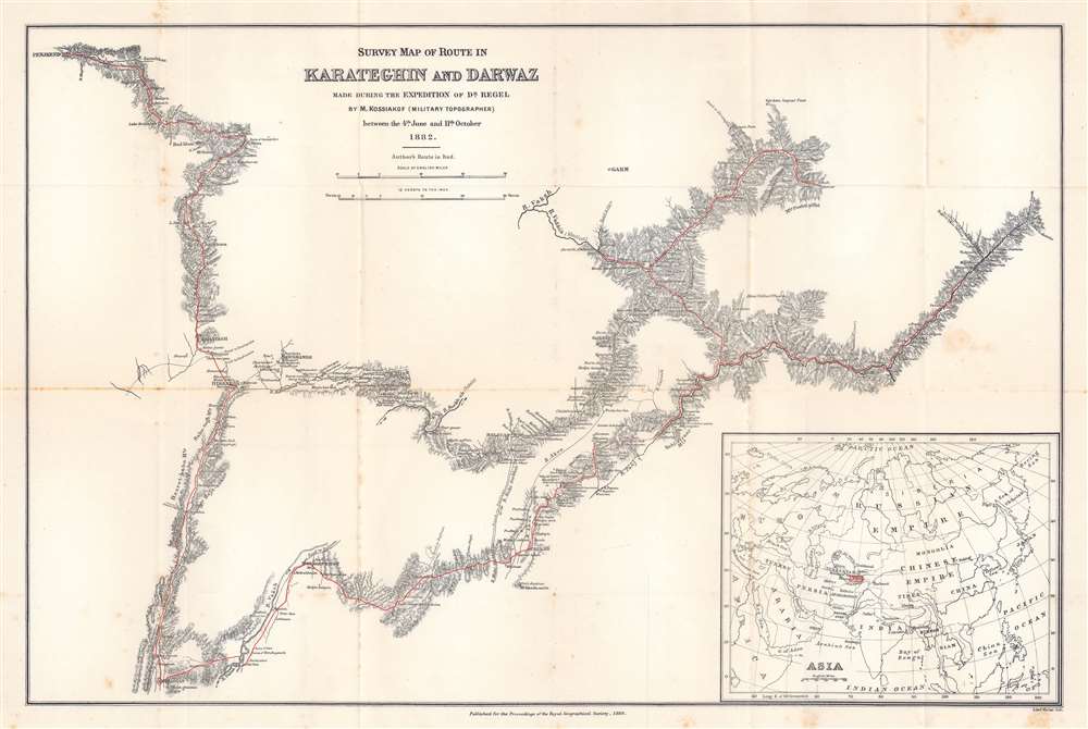
Survey Map of Route in Karateghin and Darwaz Made During the Expedition of Dr. Regel.
1886 (dated) 17 x 25.5 in (43.18 x 64.77 cm) 1 : 630000
1886 (dated) 17 x 25.5 in (43.18 x 64.77 cm) 1 : 630000
Description
This is an 1886 M. Kossiakof map of Turkestan in Central Asia. Red lines trace Kossiakof's route through the Rasht Valley (Karateghin) and Darvaz (Darwaz) regions with the 1881 Regel Expedition. The primarily botanically focused 1881 expedition was led by Johann Albert von Regel (1845 - 1909), a Swiss-Russian physician and botanist. Nonetheless, the Regel Expedition was one of the first European penetrations into the area. Kossiakof was a military topographer attached to the mission. He mapped the region, labeling cities, towns, and villages through which the group passed. Rivers are illustrated. In the lower right corner, an inset map of Asia and eastern Europe situates the depicted area in a continental manner. The map covers only the actual path followed, along with the observable surrounds, underscoring Kossiakof's integrity in illustrating only scientifically confirmed geography.
Publication History and Census
This map was engraved by Edward Weller from Kossiakof's survey map that accompanied the original Russian article. It was published in the January 1886 edition of the Proceedings of the Royal Geographical Society and Monthly Record of Geography and accompanied E. Delmar Morgan's translation of Kossiakof's article. An example is cataloged in OCLC and is part of the institutional collection at the University of Chicago.CartographerS
Edward Weller (July 1, 1819 - 1884) was a cartographer and engraver based in London. Weller was a nephew of another well-known map publisher Sidney Hall (1788 - 1831), who gave him 50 Pounds to pay his apprenticeship fees. He engraved for many prominent mapmakers and was active enough in the community to be recommended for membership to the Royal Geographical Society in 1851 on the recommendation of John Arrowsmith, among others. He eventually inherited the Sidney Hall map business which led him to follow Arrowsmith as the unofficial geographer to the Royal Geographical Society. Weller was among the first map printers in London to embrace lithography. His best known work appears in Cassell's Weekly Dispatch Atlas, published in monthly segments for subscribers of the 'Weekly Dispatch' newspaper. This collection of maps eventually grew to include much of the known world. Published in various editions from 1855 through the early 1880s. Weller died in May of 1884, leaving behind a successful business and an unhappy widow. His son, Francis Sidney Weller (1849 - 1910), followed in his father's footsteps and continued the family map business. The atlas Mackenzie's Comprehensive Gazetteer of England and Wales was published in 1894 and bore F. S. Weller's signature on the maps. More by this mapmaker...
Royal Geographical Society (fl. 1830 - present) is a British Society established in 1830 to promote geographical science and exploration. Originally titled the "Geographical Society of London", the RGS received its royal charter from Queen Victoria in 1859 shortly after absorbing several similar but more regional societies including the African Association, the Raleigh Club and the Palestine Association. The RGS sponsored many of the most important and exciting voyages of exploration ever undertaken, including the exploration of Charles Darwin, David Livingstone, Robert Falcon Scott, Richard F. Burton, John Speke, George Hayward, H. M Stanley, Ernest Shackleton and Sir Edmond Hillary. Today, the RGS remains a leading global sponsor of geographical and scientific studies. The Society is based in Lowther Lodge, South Kensington, London. Learn More...
Source
Kossiakof, M. 'Notes of a Journey in Karateghin and Darwaz in 1882 (E. Delmar Morgan Trans,)' Proceedings of the Royal Geographical Society and Monthly Record of Geography Vol. 8, No. 1. (London: Royal Geographical Society) 1886.
Condition
Very good. Exhibits light wear along original fold lines. Exhibits light foxing. Accompanied by original article.
References
OCLC 173491927.