
1975 Fine Art Printing City Plan of Kathmandu, Nepal

Kathmandu City. / Nepal Kathmandu.
Terminus of the Hippie Trail.
$350.00
Choose a Collection:
This Item
Enquire
Terminus of the Hippie Trail.
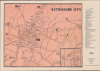
This is a 1975 pictorial map of Kathmandu, Nepal, prepared by the Fine Art Printing Press for Nepal's Department of Tourism. It was produced at a time when the city was undergoing rapid changes, thanks in part to government modernization policies and in part to the influx of foreign tourists traveling the 'Hippie Trail.'A Closer Look
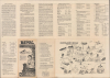
The two-tone map traces major roads, indicating their surface type, and illustrates major landmarks throughout the city, including temples, palaces, museums, and the airport, at right. Additional sites, including embassies, major hotels, and airline offices, are numbered and listed in an index at right. An inset at bottom-right covers the Durbar Square area, popular with tourists.The verso panels provide basic information about Nepal's history and culture, as well as major tourist attractions in Kathmandu, which are numbered in correspondence to a pictorial view of the Kathmandu Valley at bottom-right. The verso also lists airlines, banks, and travel agencies, hotels with rates, and other useful information for travelers. The title panel includes an illustration of a woman praying with mountains in the background.
Historical Context
Around the time this map was produced, Nepal was in an uncertain and somewhat unstable situation. The autocratic but modernizing King Mahendra (r. 1955 - 1972) had died suddenly in 1972 at only 51 years old, leaving his foreign-educated 26-year-old son Birendra (r. 1972 - 2001). As king, Birendra tried to maintain his father's panchayat system while fending off a growing pro-democracy movement, ultimately agreeing to a referendum in 1980 that narrowly maintained one-party rule and a strong monarchy but with more checks on the king's political power, a precursor to multiparty democracy a decade later.Aside from these political developments, Kathmandu had grown both demographically and economically in the preceding years thanks to Mahendra's modernizing policies and foreign tourism. Indeed, this map was produced at the height of the era of the 'Hippie Trail,' of which Kathmandu served as the terminus as travel into Tibet or Burma from northern India was extremely dangerous or downright impossible. Thus, Kathmandu was transformed in short order from the capital of a secluded kingdom under Mahendra's predecessors to a global destination for the counterculture movement. At the time, cannabis and hashish were sold legally in government-licensed shops, and a vibrant scene grew up around Jhochhen Tole, famously known as 'Freak Street,' where young Western travelers arrived in colorful buses seeking spiritual enlightenment and cheap living. This influx of tourists brought dramatic change to the Kathmandu Valley; traditional Newari houses were converted into guesthouses, and the first 'pie shops' and Western-style cafes began to dot the landscape, creating a unique cultural fusion between Kathmandu's ancient Hindu-Buddhist Himalayan aesthetics and the experimental lifestyle of the 1970s youth.
However, it was also around this time that Birendra's government began to seek ways to move beyond the 'Hippie Trail' tourism. In 1972, Nepal released a landmark Tourism Master Plan that aimed to attract higher-spending tourists by improving infrastructure and accommodations and focusing on tourism to the country's growing list of national parks and remarkable cultural sites. This shift was well-timed, as the Iranian Revolution and Soviet Invasion of Afghanistan brought the Hippie Trail to a sudden end in the late 1970s.
Publication History and Census
This map was printed in January 1975 in Kathmandu by the Fine Art Printing Press for the country's Department of Tourism. Stamps on the verso indicate its provenance through the Ohio State University's library system. The Department of Tourism issued a map with this title from 1970 and 1976. Catalog listings often co-mingle these various editions, but the present edition looks to be listed among the holdings of some eight institutions in the OCLC.Condition
Very good. Verso repairs to fold separations. Light wear along original fold lines. Slight loss at a few fold intersections. Text on verso. Manuscript writing in lower right corner of recto. Collections stamps on verso.
References
OCLC 5482059.