This item has been sold, but you can get on the Waitlist to be notified if another example becomes available, or purchase a digital scan.
1903 Donn Map of Kauai, Hawaiian Islands
Kauai-donn-1903$600.00


Title
Hawaii Territorial Survey. Kauai Hawaiian Islands.
1903 (dated) 23.75 x 30.25 in (60.325 x 76.835 cm) 1 : 90000
1903 (dated) 23.75 x 30.25 in (60.325 x 76.835 cm) 1 : 90000
Description
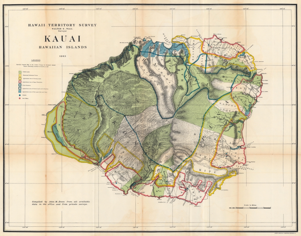
This is a stunning 1903 John M. Donn map of Kauai, created for the Hawaiian Territorial Survey. It is the first comprehensive large-scale modern map of Kauai.
A Closer Look
Donn uses color to effectively illustrate land use throughout Kauai while composing a visually stunning work. At least half the island is shaded green, emphasizing Kauai's public lands. Parts of the island are outlined in yellow (grazing lands), red (sugar plantations), or blue (forest reserves). Rivers are illustrated throughout, along with swamps, peaks (including Kilohana Crater), and other prominent features. The Na Pali Coast is visually striking, somehow conveying its majesty even on paper.Hawaiian Territorial Survey
The Hawaiian Territorial Survey supplemented the Hawaiian Government Survey in 1901, three years after the United States annexed the archipelago. (The Hawaiian Government Survey was created in 1870 to survey the Hawaiian government's land.) In 1901, the Surveyor General of the Hawaiian Government Survey, William D. Alexander, became the head of the Branch Office of the U.S. Coast and Geodetic Survey in the Hawaiian Islands and Walter E. Wall succeeded him as Territorial Surveyor. The Territorial Survey continued its work until 1959 when Hawaii became a state and thus changed to the State Survey.Publication History and Census
This map was drawn by John M. Donn in 1903 and published in the 'Governor's Annual Report, Illustrating Conditions as of June 30, 1906'. We note four examples in OCLC: The Library of Congress, the University of California San Diego, the University of California Los Angeles, and the University of California Davis. An example is also part of the David Rumsey Map Collection.CartographerS
John M. Donn (1871 - August 9, 1931) was an American architect. Donn lived and worked in Washington, D.C., and designed several government buildings. Donn served as the chief draughtsman of the Hawaiian Territorial Survey and was also the Second Assistant. He created a map of Hawaii and a map of Oahu for the Hawaii Territory Survey. He also updated a map of Maui created by the Hawaiian Government Survey. More by this mapmaker...
Walter Eugene Wall (October 13, 1867 - July 23, 1944) was an American surveyor. Born in Yreka, California, he arrived in Honolulu with his parents in 1880. His father was the architect in charge of the construction of the Iolani Palace. He began working at the Hawaiian Government Survey in 1889 and was appointed Territorial Surveyor General in 1901. He worked for the survey for more than 35 years. Wall attended the Ponahou School where he was known for his athletics, introducing the curveball (referenced as 'curve pitching in baseball' in his obituary) to Hawaii. He married Edith Louise Dietz on June 22, 1903. He died in 1944 in Honolulu. Learn More...
Andrew B. Graham (1845 - September 9, 1909) was an American lithographer active in Washington, D.C. in late 19th and early 20th century. Graham was born in Washington D.C., the son of a lithographer and engraver. After college, he joined the U.S. Coast Survey, where he was a draftsman until 1889. He retired from the Coast Survey to take over management of his father's lithography firm. The firm, Andrew B. Graham Company, was one of several that thrived on lucrative government publication contracts. Graham died of 'brain fever' in his Washington D. C. residence on September 9 of 1909. Some of his work was republished posthumously until about 1917, and his firm was active until at least the early 1920s. Learn More...
Source
Governor of Hawaii Board of Indian Commissioners, 'Report of the Governor of Hawaii', Annual Reports of the Department of the Interior for the Fiscal Year Ended June 30, 1906, (Washington: Government Printing Office) 1907.
Condition
Good. Light wear and some soiling along original fold lines. Some offsetting. Verso repairs to fold separations and at fold intersections. Closed tear extending one inch into printed area from left margin professionally repaired on verso.
References
Rumsey 3705.003. OCLC 145340201.