1950 George Philip and Son Map of the Royal Nairobi National Park
KenyaNationalParks-mathews-1950$500.00

Title
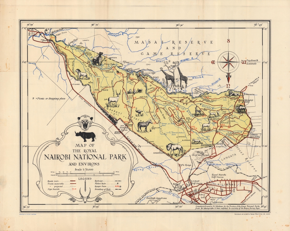
Map of the Royal Nairobi National Park and Environs.
1950 (dated) 16.5 x 21.5 in (41.91 x 54.61 cm) 1 : 50000
1950 (dated) 16.5 x 21.5 in (41.91 x 54.61 cm) 1 : 50000
Description
An attractive 1950 pictorial map of Kenya by Dennis Own Mathews, a surveyor and cartographer who served as the General Manager of the East African Tourist Travel Association. The recto highlights the Royal Nairobi National Park, opened only a few years prior, while the verso (back) records the locations of all Kenyan national parks and reserves.
A Closer Look
The map is oriented to the south with north at bottom. The park is distinguished by yellow shading and is ringed by a dashed line. Illustrations of animals appear throughout, including lions, hippos, giraffes, gazelles, and zebras. Roads, rivers, and other features are indicated, along with symbols for ranger stations, dams, highlands, and picnic areas. Outside the park, roads, railways, and airports serve the built-up portion of Nairobi. On the verso, a similar map at a larger scale depicts all the national parks and reserves in Kenya, with an inset of Nairobi National Park.Nairobi National Park
The (Royal) Nairobi National Park, opened in 1946, was largely the brainchild of a single man, conservationist Mervyn Cowie, who served as the park's director until 1966. Cowie was born in Nairobi in the early 20th century and became alarmed about the disappearance of game animals from the city's southern hinterland (the lands around Nairobi were traditionally traversed by pastoralist Maasai and their flocks before being handed over to British farmers at the turn of the 20th century). Although a Southern Game Reserve had been established which barred hunting, the area was not protected from farming, grazing, or other activities that negatively impacted the wildlife. Thus, through extensive lobbying, Cowie and his allies were able to pressure the colonial government to expand the existing reserve and elevate it to a national park with greater protections. Since opening, the park has been a resounding success in terms of attracting tourists, aided by its very close proximity to Nairobi.Publication History and Census
This map was drawn and compiled by Dennis Own Mathews in January 1950 and was published in London by George Philp and Son. It is not cataloged among the holdings of any institution.CartographerS
Dennis Owen Mathews (February 21, 1901 - 197?) was an English army officer, artist, cartographer, and travel-industry businessman active in the early to middle 20th century. Mathews was born in London and educated at Latymer School, London and Varndean School, Brighton. He joined the Royal Air Force in 1918, towards the end of World War I. After the war he was assigned to the Uganda Survey Department, Royal Engineers, where he served from 1921 to 1946. In 1948 he became the General Manager of the East African Tourist Travel Association, a position which he held until 1963. He was the United Nations Tourism Expert in 1965 and the Director of Tourism of the Seychelles from 1965 to 1966. Later he became the General Manager of Downey and Selby Safaris from 1967 to 1970. During his service as General Manager of the East African Tourist Travel Association, he drew and published several pictorial maps of different parts of East Africa. His works includes maps of Kenya, Tanzania, Uganda, Gedi, and Kampala. He was a Fellow of the Royal Geographical Society, was recognized in 1959 as an Officer of the Most Excellent Order of the British Empire (OBE), and in 1965 as a Knight of the Most Distinguished Order of Saint Michael and Saint George. He was also an avid big game hunter. In the world of cartography, Mathews is significant as one of the few pictorial cartographers to produce maps focused on African topics. More by this mapmaker...
George Philip (1800 - 1882) was a map publisher and cartographer active in the mid to late-19th century. Philip was born into a Calvinst family in Huntly, Aberdeenshire, Scotland. Around 1819 he apprenticed himself to William Grapel, a Liverpool printer and bookseller. Fifteen years later, in 1834, Philip founded his own Liverpool book and map firm. Philip's earliest cartographic ventures were mostly educational material issued in tandem with John Bartholomew Sr., August Petermann, and William Hughes. In 1848, Philip admitted his son, George Philip Jr. (1823 - 1902) into the firm, renaming it George Philip and Son Ltd. George Philip Jr. ran the firm until his death in 1902, by which time it had developed into a major publishing concern. His successors established the London Geographical Institute, a factory where they embraced modern printing techniques to produce thousands of economical and high quality maps. In April 1988, George Philip & Son was acquired by Octopus Publishing, a branch of Reed International. Nonetheless, today the firm trades and publishes to this day as George Philip and Son. Learn More...
Condition
Very good. Some creasing along fold lines. Sporadic soiling.