This item has been sold, but you can get on the Waitlist to be notified if another example becomes available, or purchase a digital scan.
1945 Defence Overprint Map of the Southeastern Netherlands (Operation Veritable)
KesselReuverSheet4702-defence-1945$450.00

Title
Germany 1:25000. Defence Overprint Sheet 4702 Edition of 7 Feb. 45.
1945 (dated) 19 x 23 in (48.26 x 58.42 cm) 1 : 25000
1945 (dated) 19 x 23 in (48.26 x 58.42 cm) 1 : 25000
Description
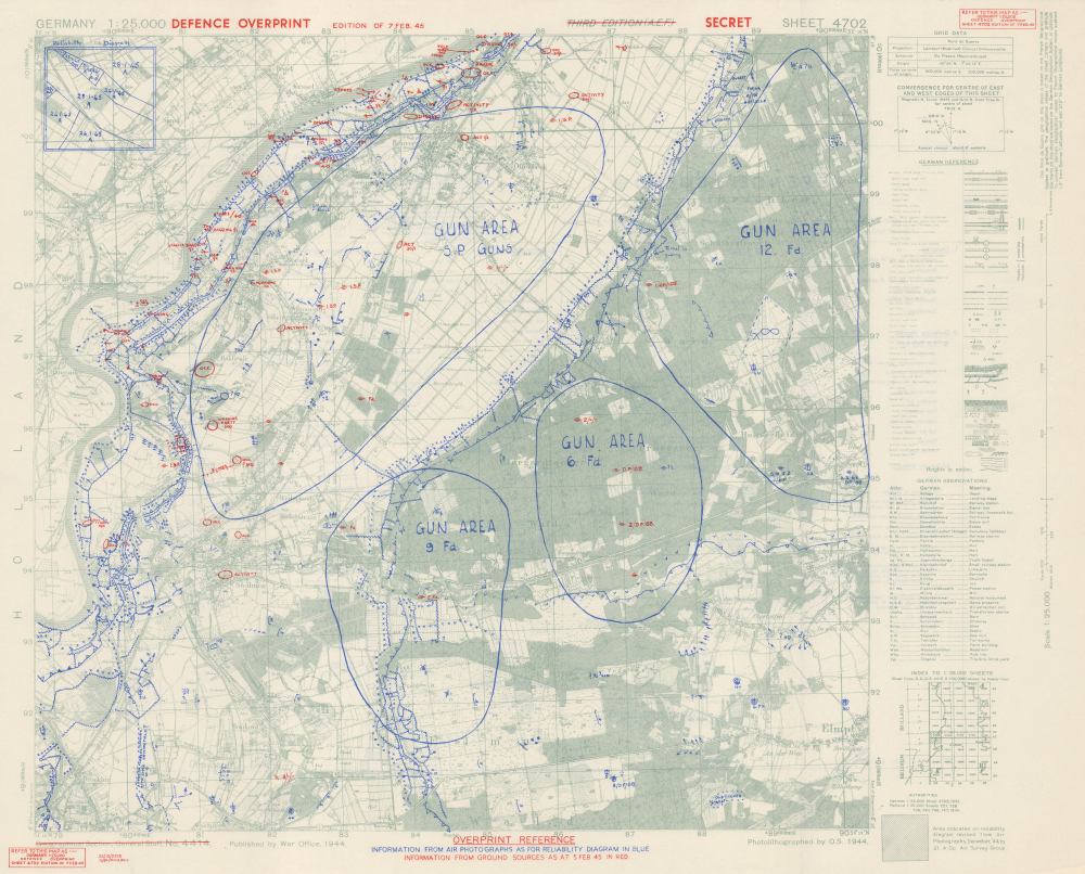
This is a February 1945 World War I (1914 - 1918) Defence Overprint map of the southeastern Netherlands. Created for British and Canadian forces advancing as part of Operation Veritable, the map highlights German defensive positions along the Meuse River, including a network of trenches and machine gun emplacements that run along the riverbank.
A Closer Look
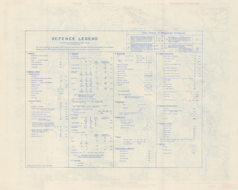
Blue and red overprinting are the tactical essence of this piece. Overprinting highlights German defenses, with blue content representing intelligence gathered by aerial photography throughout January 1945 in preparation for Operation Venerable and Operation Grenade, while the red represents information gathered on foot. The lines of blue Xs along the Meuse River and elsewhere are barbed wire. The squiggly lines behind the Xs are trenches, some of which are protected by anti-tank obstacles. The arrows represent machine guns pointed at the Allies on the other side of the Meuse. Other gun emplacements, artillery, pillboxes, mortars, and various types of German positions are noted as well. A key to the symbols used by the War Office on the base map appears to the right, while an extensive key explaining the overprinted symbols occupies most of the verso.Operation Veritable and Operation Grenade
Operation Veritable and Operation Grenade were the northern and southern parts, respectively, of an Allied pincer movement to capture German soldiers between the Rivers Meuse and Rhine. These operations were part of the Rhineland Campaign in the Netherlands and Germany. Operation Venerable launched on February 8, 1945, and was undertaken by British and Canadian troops. Operation Grenade, launched on February 9, 1945, with the American Ninth Army, meant to cross the Roer River and link up with the British and Canadian troops advancing from the north. That day, the Germans opened the sluice gates on the upper Roer dams, flooding the valley. This prevented the Americans from crossing the river until February 23, delaying the battle and throwing a wrench in the pincer movement. This should have given the Germans plenty of time to retreat to the east side of the Rhine, but Hitler ordered the German Army to stand and fight where it was. This fateful decision led to the Germans losing 90,000 men by March 10, 1945, 50,000 of whom were taken prisoner.Publication History and Census
The base map was created by the Geographical Section, General Staff, and published by the War Office in 1944. This edition of the map was created and published by an engineer company in the field and published on February 7, 1945. This is the only known surviving example of the present sheet. Various Defense Overprint maps are cataloged in institutional collections in the United States and Europe and occasionally appear on the market.Cartographer
The British War Office (1857 - 1964) was a department of the British Government responsible for the administration of the Royal Army until 1964, when its functions were transferred to the Ministry of Defense. The War Office was to the Royal Army what the Admiralty was to the Royal Navy, and later, the Air Ministry. Within the War Office, the General Staff Topographical Section was responsible for thousands of maps issued for British intelligence and military use. The Topographical Section was renamed Geographical Section in April 1907. Many, once their military use passed, were offered through licensed agents to the general public. The sole London agent for War Office material was Edward Stanford. More by this mapmaker...
Condition
Excellent.