1874 Carcereri Map of Khartoum and Environs, White Nile Region
KhartoumWhiteNile-carcereri-1874$350.00

Title
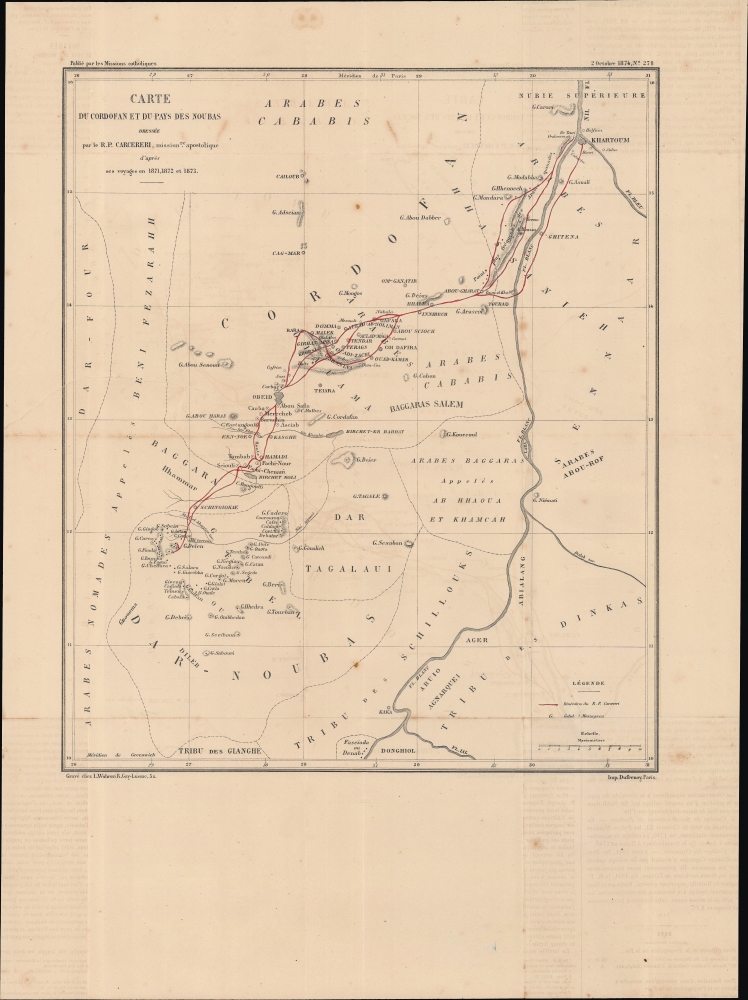
Carte du Cordofan et du pays des Noubas.
1874 (dated) 15.5 x 13 in (39.37 x 33.02 cm) 1 : 1275000
1874 (dated) 15.5 x 13 in (39.37 x 33.02 cm) 1 : 1275000
Description
An 1874 map of the White Nile, taking in Khartoum and El-Obeid, drawn by Stanislao Carcereri for Les Missions Catholiques, a missionary publication. It depicts the travels of Carcereri and his fellow Camillian missionaries, who established the first Christian churches in the region.
It is worth noting that this map was published in the wake of David Livingstone's explorations of central Africa, and that, like Livingstone, Carcereri was dedicated to using exploration as a means to eradicate the slave trade in eastern Africa. Another fierce opponent of slavery, Charles 'Chinese' Gordon, was in 1873 appointed by the Egyptian khedive as governor of the Equatorial Provinces of Sudan, which included the lands seen here. Gordon angered the Arab slave trading elite of the region, which helped lay the basis for the Mahdist Uprising in 1882. When the Mahdists overran El-Obeid, the mission structures established by Carcereri were abandoned and the city was destroyed by the rebels; both were rebuilt following the collapse of the Mahdists at the end of the 19th century.
A Closer Look
Coverage includes a large portion of central Sudan between the White Nile and Darfur. Aside from the Nile, other waterways, mountains and areas of elevation, settlements, and the rough borders of different ethnic groups are noted. The route of Carcereri and his companions is traced in red. 'Cordofan' in the title refers to Kordofan, a historic name for this region, while 'Noubas' is derived from the Nuba peoples, a collection of related ethnic groups in central Sudan, or perhaps the Nuba Mountains of the same region.Exploring Upper Egypt and the Sudan
Carcereri and his companions set out from Khartoum in October 1871, heading southwest, initially along the White Nile but quickly heading inland towards Darfur, areas hitherto little known to Europeans. In January, they reached El Obeid, an important outpost built by the Egyptians / Ottomans following their conquest of Sudan in the early 1820s. They continued traveling southwest until reaching highlands, beyond which the arid and desert terrain of Sudan transitions to greener vegetation, lands that at the time were even more mysterious to Europeans than Kordofan.It is worth noting that this map was published in the wake of David Livingstone's explorations of central Africa, and that, like Livingstone, Carcereri was dedicated to using exploration as a means to eradicate the slave trade in eastern Africa. Another fierce opponent of slavery, Charles 'Chinese' Gordon, was in 1873 appointed by the Egyptian khedive as governor of the Equatorial Provinces of Sudan, which included the lands seen here. Gordon angered the Arab slave trading elite of the region, which helped lay the basis for the Mahdist Uprising in 1882. When the Mahdists overran El-Obeid, the mission structures established by Carcereri were abandoned and the city was destroyed by the rebels; both were rebuilt following the collapse of the Mahdists at the end of the 19th century.
Publication History and Census
This map was prepared by Paolo Stanislao Carcereri and published in Les Missions Catholiques, a missionary publication, in 1874. It was engraved by Frédéric Louis Charles Wuhrer and published by Eugène Dufrenoy. The map is independently cataloged by the Staatsbibliothek zu Berlin, while Les Missions Catholiques is more widely distributed in institutional collections.CartographerS
Paolo Stanislao Carcereri (1840 - 1899) was an Italian Camillian missionary who helped to establish the first Christian presence in the Sudan and the White Nile region. Along with fellow missionaries, he set out from Khartoum in 1871 and spent the next two years traveling throughout Upper Egypt and Sudan, establishing a mission station at El-Obeid, and eventually reaching as far as Kordofan. Afterwards, he published a map of the region that was far superior to earlier maps and won plaudits from the geographic community throughout Europe. More by this mapmaker...
Frédéric Louis Charles Wuhrer (1844 - 1925) was a French cartographer, engraver, and artist. He lived in the town of Buc, France, where he purchased the former Town Hall. Wuhrer is better known as a landscape artist, with a strong record at auctions. Little is known of his engraving work, but the Bibliothèque nationale de France has over one hundred pieces in their collection attributed to his name. Learn More...
Eugène Dufrenoy (January 21, 1834 - 190x), aka Dufrenois, was a French printer, lithographer, and engraver active in Paris during the second half of the 19th and the early 20th centuries. Dufrénoy born in Bourg-la-Reine, in what is today the southern suburbs of Paris. He was based, for at least part of his career, at 34 Rue du Four, Paris. In 1881 Dufrénoy acquired a large space at 49 Rue du Montparnasse. This space still operates as a printshop with Dufrénoy's old presses as IDEM Paris. ˜ Learn More...
Source
Les Missions Catholiques, No. 278, (Lyon: Dufrenoy, October 2, 1874).
Condition
Good. Light wear along original fold lines. Light foxing. Light offsetting.
References
OCLC 837755754.