This item has been sold, but you can get on the Waitlist to be notified if another example becomes available, or purchase a digital scan.
1885 Johnston Map of Mount Kilimanjaro, Tanzania
Kilimanjaro-johnston-1885$275.00

Title
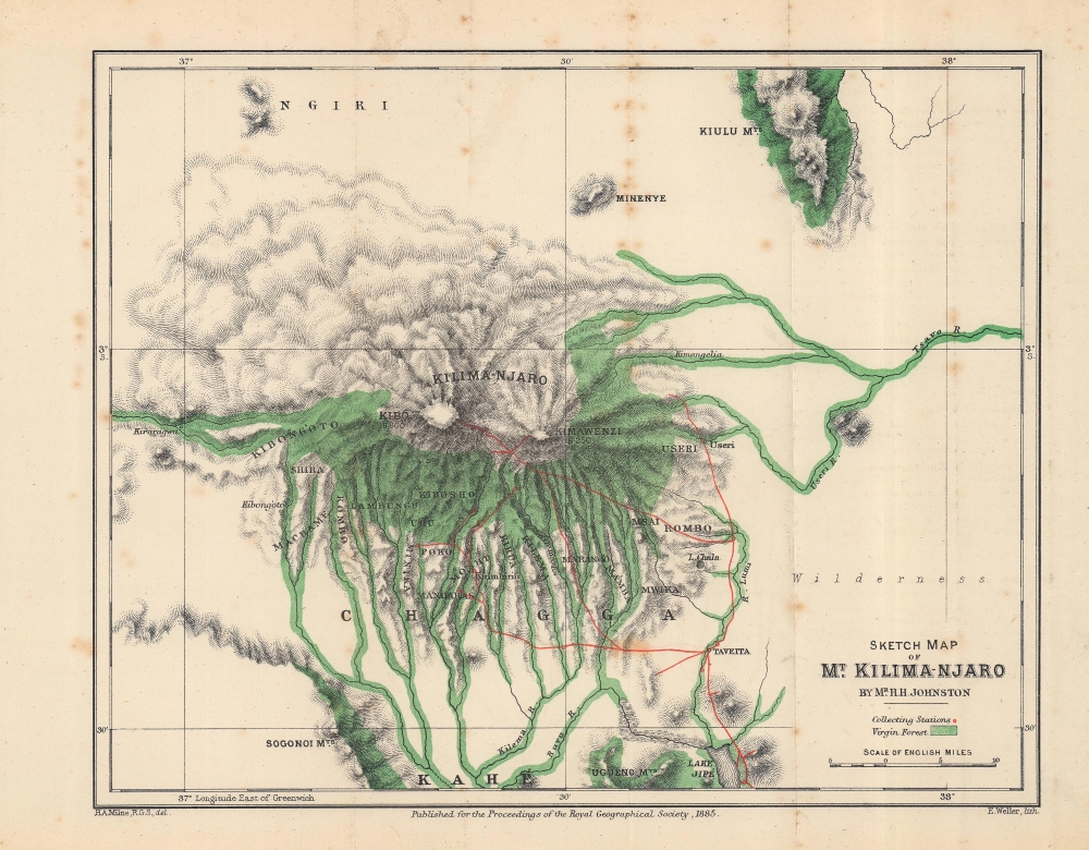
Sketch Map of Mt. Kilima-Njaro.
1885 (dated) 8.25 x 10.25 in (20.955 x 26.035 cm) 1 : 506880
1885 (dated) 8.25 x 10.25 in (20.955 x 26.035 cm) 1 : 506880
Description
This is an 1884 Henry Johnston map of Mount Kilimanjaro, Tanzania. It is one of the earliest obtainable specific maps of Kilimanjaro. The Johnston expedition was set against the colonial backdrop of conflict between German and British claims in East Africa.
A Closer Look
The map focuses on Mt. Kilimanjaro, with brilliant green highlighting the 'virgin forests'. Its three volcanic cones, Kibo, Mawenzi (Kimawenzi), and Shira are identified with altitudes provided for Kibo and Mawenzi. Red lines trace Johnston's peregrinations and red circles mark 'collecting stations'.The 1884 Kilimanjaro Expedition
In 1884, Henry Johnston led an expedition to Kilimanjaro. While ostensibly a scientific expedition, Johnston's biographers note that he also negotiated several tribal treaties which were later transferred to the British East Africa Company and helped establish boundaries between British and German possessions. Nonetheless, Johnston spent months on the slopes gathering scientific data, most of which was not ground-breaking, but expanded, supplemented, and clarified existing data.Publication History and Census
This map was created by Henry H. Johnston, engraved by H. A. Milne, lithographed by Edward Weller, and published in the March 1885 edition of the Proceedings of the Royal Geographical Society and Monthly Record of Geography. We note two cataloged examples: British Library and the University of Wisconsin - Milwaukee. An example, along with the proof with printing instructions, is part of the collection at the National Archives, Kew.CartographerS
Server Error
404
Page Not Found
This page either doesn't exist, or it moved somewhere else.
That's what you can do
H. A. Milne (fl. 1879 - 1887) was a British draftsman and cartographer. Milne joined the in-house drawing office in 1879 as an assistant to William John Turner. When Turner resigned in 1881 to join W. And A. K. Johnston in Edinburgh, Milne applied for the position but was overlooked in favor of Henry Scharbau (anglicized Sharbau). Milne continued on as Sharbau's assistant until 1887 when the Royal Geographical Society let him go because of ill-health and prolonged absence. Learn More...
Edward Weller (July 1, 1819 - 1884) was a cartographer and engraver based in London. Weller was a nephew of another well-known map publisher Sidney Hall (1788 - 1831), who gave him 50 Pounds to pay his apprenticeship fees. He engraved for many prominent mapmakers and was active enough in the community to be recommended for membership to the Royal Geographical Society in 1851 on the recommendation of John Arrowsmith, among others. He eventually inherited the Sidney Hall map business which led him to follow Arrowsmith as the unofficial geographer to the Royal Geographical Society. Weller was among the first map printers in London to embrace lithography. His best known work appears in Cassell's Weekly Dispatch Atlas, published in monthly segments for subscribers of the 'Weekly Dispatch' newspaper. This collection of maps eventually grew to include much of the known world. Published in various editions from 1855 through the early 1880s. Weller died in May of 1884, leaving behind a successful business and an unhappy widow. His son, Francis Sidney Weller (1849 - 1910), followed in his father's footsteps and continued the family map business. The atlas Mackenzie's Comprehensive Gazetteer of England and Wales was published in 1894 and bore F. S. Weller's signature on the maps. Learn More...
Royal Geographical Society (fl. 1830 - present) is a British Society established in 1830 to promote geographical science and exploration. Originally titled the "Geographical Society of London", the RGS received its royal charter from Queen Victoria in 1859 shortly after absorbing several similar but more regional societies including the African Association, the Raleigh Club and the Palestine Association. The RGS sponsored many of the most important and exciting voyages of exploration ever undertaken, including the exploration of Charles Darwin, David Livingstone, Robert Falcon Scott, Richard F. Burton, John Speke, George Hayward, H. M Stanley, Ernest Shackleton and Sir Edmond Hillary. Today, the RGS remains a leading global sponsor of geographical and scientific studies. The Society is based in Lowther Lodge, South Kensington, London. Learn More...
Source
Johnston, H. H., 'The Kilima-njaro Expedition', Proceedings of the Royal Geographical Society and Monthly Record of Geography, Vol. 7, No. 3 (Mar. 1885) (London: Stanford) 1885.
Condition
Very good. Light wear along original fold lines. Some foxing.
References
National Archives, Kew, MPK 1/160/6. OCLC 557866016, 1049173400.