1900 Pearce Map of Malawi and Mozambique (British Central Africa Protectorate)
LakeChiutaRiverLuli-pearce-1900$250.00

Title
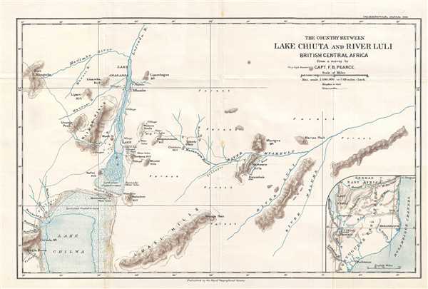
The Country Between Lake Chiuta and River Luli. British Central Africa.
1900 (dated) 10.5 x 15.75 in (26.67 x 40.005 cm) 1 : 500000
1900 (dated) 10.5 x 15.75 in (26.67 x 40.005 cm) 1 : 500000
Description
Depicting what Pearce calls 'the hitherto blank piece of country between Lake Chiuta and the Luli river', this is a 1900 Captain F. B. Pearce map of part of Malawi and Mozambique. Then divided between British Central Africa and Portuguese Mozambique, this map focuses on a portion of East Africa between Lake Chilwa in Malawi and the Lurio River in Mozambique. Per an article in The Geographical Journal, the map was surveyed by Pearce during a joint Anglo-Portuguese military expedition undertaken in 1899 against the slave-raiding chief Kwamba. Numerous villages are labeled throughout the region, along with hills, ridges, mountains, and forests. The flood plains of both Lake Chilwa and Lake Chiuta are illustrated, demonstrating to its viewers the vast differences between the African wet and dry season in this part of the continent. An inset map in the lower right corner situates the depicted region in East Africa in general, allowing the viewer to note that Lake Chilwa is not far from Lake Nyassa (Lake Malawi), that it borders Portuguese East Africa, and that German East Africa is not far to the north.
This map was created by Captain F. B. Pearce and printed by the Royal Geographical Society in its Geographical Journal in 1900.
This map was created by Captain F. B. Pearce and printed by the Royal Geographical Society in its Geographical Journal in 1900.
Cartographer
Royal Geographical Society (fl. 1830 - present) is a British Society established in 1830 to promote geographical science and exploration. Originally titled the "Geographical Society of London", the RGS received its royal charter from Queen Victoria in 1859 shortly after absorbing several similar but more regional societies including the African Association, the Raleigh Club and the Palestine Association. The RGS sponsored many of the most important and exciting voyages of exploration ever undertaken, including the exploration of Charles Darwin, David Livingstone, Robert Falcon Scott, Richard F. Burton, John Speke, George Hayward, H. M Stanley, Ernest Shackleton and Sir Edmond Hillary. Today, the RGS remains a leading global sponsor of geographical and scientific studies. The Society is based in Lowther Lodge, South Kensington, London. More by this mapmaker...
Source
The Geographical Journal Vol. XV, No. 6, June 1900.
Condition
Very good. Light foxing. Light wear along original fold lines. Blank on verso.
References
OCLC 65644981.